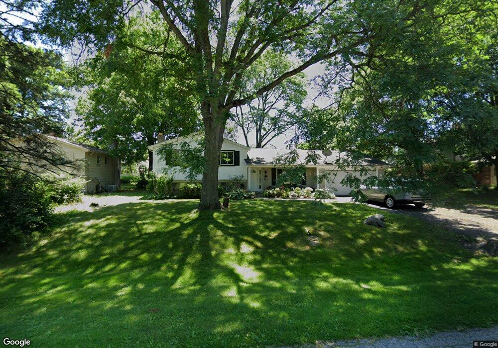
7071 Lee Crest Dr West Bloomfield, MI 48322
Estimated Value: $378,977 - $413,000
4
Beds
2
Baths
2,300
Sq Ft
$172/Sq Ft
Est. Value
About This Home
This home is located at 7071 Lee Crest Dr, West Bloomfield, MI 48322 and is currently estimated at $395,244, approximately $171 per square foot. 7071 Lee Crest Dr is a home located in Oakland County with nearby schools including Sheiko Elementary School, West Bloomfield Middle School, and Bloomfield Maples Montessori.
Ownership History
Date
Name
Owned For
Owner Type
Purchase Details
Closed on
Oct 1, 2010
Sold by
Maruszczak Natalie and Sclawy Steven H
Bought by
Tongbua Matee
Current Estimated Value
Purchase Details
Closed on
Dec 9, 1996
Sold by
Hsieh Bing Tai
Bought by
Selawy Steven H
Create a Home Valuation Report for This Property
The Home Valuation Report is an in-depth analysis detailing your home's value as well as a comparison with similar homes in the area
Home Values in the Area
Average Home Value in this Area
Purchase History
| Date | Buyer | Sale Price | Title Company |
|---|---|---|---|
| Tongbua Matee | $120,000 | Troy Abstract & Title Agency | |
| Selawy Steven H | $165,000 | -- |
Source: Public Records
Tax History Compared to Growth
Tax History
| Year | Tax Paid | Tax Assessment Tax Assessment Total Assessment is a certain percentage of the fair market value that is determined by local assessors to be the total taxable value of land and additions on the property. | Land | Improvement |
|---|---|---|---|---|
| 2024 | $2,128 | $153,810 | $0 | $0 |
| 2022 | $2,038 | $129,120 | $34,620 | $94,500 |
| 2021 | $3,096 | $125,860 | $0 | $0 |
| 2020 | $1,997 | $124,370 | $34,620 | $89,750 |
| 2018 | $2,985 | $102,710 | $26,630 | $76,080 |
| 2015 | -- | $81,870 | $0 | $0 |
| 2014 | -- | $76,400 | $0 | $0 |
| 2011 | -- | $80,420 | $0 | $0 |
Source: Public Records
Map
Nearby Homes
- 7027 Beverly Crest Dr
- 6843 Leslee Crest Dr
- 6769 Heather Heath
- 7023 Wild Ridge Ln
- 6624 Mellow Wood Ln
- 7421 Heather Heath
- 7335 Coach Ln
- 6651 Hearthside Ct Unit 1
- 6614 Embers Ct
- 6621 Bellows Ct Unit 62
- 7477 Heather Heath
- 4392 Gateway Cir Unit 59
- 7251 N Briarcliff Knoll Dr
- 4161 Breckenridge Dr
- 30515 W 14 Mile Rd Unit 30
- 30515 W 14 Mile Rd Unit 37
- 30475 W 14 Mile Rd Unit 80
- 30475 W 14 Mile Rd Unit 95
- 6322 Pepper Hill St Unit 62
- 6222 Pepper Hill St
- 7095 Lee Crest Dr
- 7063 Lee Crest Dr
- 7112 Beverly Crest Dr
- 7072 Lee Crest Dr
- 7049 Beverly Crest Dr
- 7051 Lee Crest Dr
- 7092 Beverly Crest Dr
- 7072 Beverly Crest Dr
- 7121 Beverly Crest Dr
- 7100 Beverly Crest Dr
- 7039 Lee Crest Dr
- 7054 Beverly Crest Dr
- 7024 Lee Crest Dr
- 7133 Beverly Crest Dr
- 7036 Beverly Crest Dr
- 7125 Beverly Crest Dr
- 7027 Lee Crest Dr
- 7109 Beverly Crest Dr
- 7054 Heather Heath
- 6997 Beverly Crest Dr