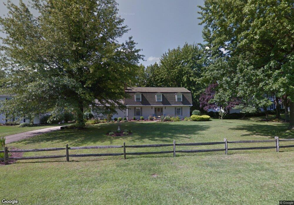
7078 Sandpiper Ct Painesville, OH 44077
Estimated Value: $371,749 - $492,000
4
Beds
3
Baths
1,808
Sq Ft
$239/Sq Ft
Est. Value
About This Home
This home is located at 7078 Sandpiper Ct, Painesville, OH 44077 and is currently estimated at $431,437, approximately $238 per square foot. 7078 Sandpiper Ct is a home located in Lake County with nearby schools including Henry F. Lamuth Middle School, Riverside Junior/Senior High School, and Hershey Montessori Elementary School.
Ownership History
Date
Name
Owned For
Owner Type
Purchase Details
Closed on
Feb 12, 2008
Sold by
Baum Stephen A and Baum Robin S
Bought by
Brown David A and Masterson Brown Patricia A
Current Estimated Value
Home Financials for this Owner
Home Financials are based on the most recent Mortgage that was taken out on this home.
Original Mortgage
$216,000
Outstanding Balance
$41,993
Interest Rate
6.11%
Mortgage Type
Purchase Money Mortgage
Estimated Equity
$389,445
Purchase Details
Closed on
Mar 13, 1986
Bought by
Baum Stephen A
Create a Home Valuation Report for This Property
The Home Valuation Report is an in-depth analysis detailing your home's value as well as a comparison with similar homes in the area
Home Values in the Area
Average Home Value in this Area
Purchase History
| Date | Buyer | Sale Price | Title Company |
|---|---|---|---|
| Brown David A | $92,000 | Enterprise Title | |
| Baum Stephen A | -- | -- |
Source: Public Records
Mortgage History
| Date | Status | Borrower | Loan Amount |
|---|---|---|---|
| Open | Brown David A | $216,000 |
Source: Public Records
Tax History Compared to Growth
Tax History
| Year | Tax Paid | Tax Assessment Tax Assessment Total Assessment is a certain percentage of the fair market value that is determined by local assessors to be the total taxable value of land and additions on the property. | Land | Improvement |
|---|---|---|---|---|
| 2024 | -- | $119,310 | $21,710 | $97,600 |
| 2023 | $8,372 | $86,680 | $17,340 | $69,340 |
| 2022 | $4,535 | $86,680 | $17,340 | $69,340 |
| 2021 | $4,553 | $86,680 | $17,340 | $69,340 |
| 2020 | $4,462 | $75,360 | $15,070 | $60,290 |
| 2019 | $4,455 | $75,360 | $15,070 | $60,290 |
| 2018 | $4,470 | $68,880 | $15,070 | $53,810 |
| 2017 | $4,311 | $68,880 | $15,070 | $53,810 |
| 2016 | $3,959 | $68,880 | $15,070 | $53,810 |
| 2015 | $3,713 | $68,880 | $15,070 | $53,810 |
| 2014 | $3,445 | $64,050 | $15,070 | $48,980 |
| 2013 | $3,445 | $64,050 | $15,070 | $48,980 |
Source: Public Records
Map
Nearby Homes
- 7065 Brightwood Dr
- 7057 Brightwood Dr
- 9956 Johnnycake Ridge Rd Unit D9
- 10001 Johnnycake Ridge Rd
- 7300 Morley Rd
- 8 Johnnycake Ridge Rd
- 9846 Old Johnnycake Ridge Rd
- 10235 Hoose Rd
- 9820 Old Johnnycake Ridge Rd Unit 5
- 7460 Thatchum Ln
- 9828 Gabriel's Way
- 339 Barrington Ridge Rd
- 9840 Johnnycake Ridge Rd
- 6677 Stratford Rd
- 2051 Kingsborough Dr
- 2155 Ridgebury Dr
- 7152 Rippling Brook Ln Unit L6
- 6624 Belvoir Ct
- 41 Warrington Ln
- SL 11 Topaz Ct
- 7090 Sandpiper Ct
- 7068 Sandpiper Ct
- 7100 Sandpiper Ct
- 7101 Brightwood Dr
- 7103 Brightwood Dr
- 7087 Sandpiper Ct
- 10200 Stonehedge Dr
- 7077 Sandpiper Ct
- 10206 Stonehedge Dr
- 7105 Brightwood Dr
- 7097 Sandpiper Ct
- 7067 Sandpiper Ct
- 7110 Sandpiper Ct
- 7107 Brightwood Dr
- 10216 Stonehedge Dr
- 7112 Sandpiper Ct
- 7101 Sandpiper Ct
- 7104 Brightwood Dr
- 7102 Brightwood Dr
- 7062 Teal Cove