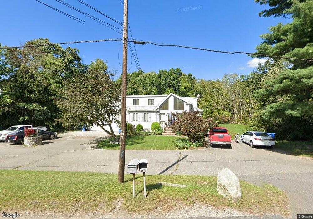
708 Franklin St Wrentham, MA 02093
Estimated Value: $792,000 - $895,000
5
Beds
5
Baths
2,809
Sq Ft
$304/Sq Ft
Est. Value
About This Home
This home is located at 708 Franklin St, Wrentham, MA 02093 and is currently estimated at $853,826, approximately $303 per square foot. 708 Franklin St is a home located in Norfolk County with nearby schools including Delaney Elementary School and Charles E Roderick.
Ownership History
Date
Name
Owned For
Owner Type
Purchase Details
Closed on
Jun 25, 2020
Sold by
Giacalone Vito and Giacalone Mary
Bought by
Giacalone Lt
Current Estimated Value
Purchase Details
Closed on
Dec 24, 1980
Bought by
Giacalone Vito and Giacalone Mary
Create a Home Valuation Report for This Property
The Home Valuation Report is an in-depth analysis detailing your home's value as well as a comparison with similar homes in the area
Home Values in the Area
Average Home Value in this Area
Purchase History
| Date | Buyer | Sale Price | Title Company |
|---|---|---|---|
| Giacalone Lt | -- | None Available | |
| Giacalone Vito | -- | -- |
Source: Public Records
Mortgage History
| Date | Status | Borrower | Loan Amount |
|---|---|---|---|
| Previous Owner | Giacalone Vito | $40,000 |
Source: Public Records
Tax History Compared to Growth
Tax History
| Year | Tax Paid | Tax Assessment Tax Assessment Total Assessment is a certain percentage of the fair market value that is determined by local assessors to be the total taxable value of land and additions on the property. | Land | Improvement |
|---|---|---|---|---|
| 2025 | $8,355 | $720,900 | $318,900 | $402,000 |
| 2024 | $8,296 | $691,300 | $318,900 | $372,400 |
| 2023 | $8,217 | $651,100 | $283,200 | $367,900 |
| 2022 | $7,264 | $531,400 | $288,600 | $242,800 |
| 2021 | $7,713 | $548,200 | $260,400 | $287,800 |
| 2020 | $6,823 | $478,800 | $206,400 | $272,400 |
| 2019 | $6,834 | $484,000 | $198,100 | $285,900 |
| 2018 | $6,609 | $464,100 | $195,100 | $269,000 |
| 2017 | $6,159 | $432,200 | $191,400 | $240,800 |
| 2016 | $6,026 | $422,000 | $185,800 | $236,200 |
| 2015 | $5,787 | $386,300 | $178,700 | $207,600 |
| 2014 | $5,593 | $365,300 | $172,000 | $193,300 |
Source: Public Records
Map
Nearby Homes
- 570 Franklin St
- 50 Reed Fulton Ave Unit Lot 61
- 45 Joshua Rd
- 131 Creek St Unit 7
- 12 Waites Crossing Way
- 11 Elliot Mills Unit 11
- 246 Forest Grove Ave
- 10 Nature View Dr
- 15 Nature View Dr
- Lot 3 - 14 Earle Stewart Ln
- 11 Earle Stewart Ln
- Lot 1 - Blueberry 2 Car Plan at King Philip Estates
- Lot 8 - Blueberry 2 Car Plan at King Philip Estates
- Lot 5 - Hughes 2 car Plan at King Philip Estates
- Lot 6 - Blueberry 3 Car Plan at King Philip Estates
- Lot 2 - Camden 2 Car Plan at King Philip Estates
- Lot 7 - Cedar Plan at King Philip Estates
- Lot 4 - Hemingway 2 Car Plan at King Philip Estates
- Lot 3 - Blueberry 2 Car Plan at King Philip Estates
- 11 Waites Crossing
- 10 Black Birch Cir
- 20 Black Birch Cir
- 30 Black Birch Cir
- 30 Arlene Dr
- 40 Black Birch Cir
- 15 Black Birch Cir
- 50 Black Birch Dr
- 25 Black Birch Cir
- 35 Black Birch Cir
- 135 Partridge View Ln N
- 60 Black Birch Dr
- 25 Arlene Dr
- 35 Arlene Dr
- 70 Black Birch Dr
- 45 Black Birch Cir
- 125 Partridge View Ln N Unit 88
- 15 Arlene Dr
- 20 Red Fox Run
- 30 Red Fox Run
- 50 Arlene Dr