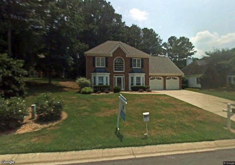
708 Jamie Way NE Woodstock, GA 30188
Sandy Plains NeighborhoodEstimated Value: $393,251 - $422,000
4
Beds
3
Baths
2,094
Sq Ft
$197/Sq Ft
Est. Value
About This Home
This home is located at 708 Jamie Way NE, Woodstock, GA 30188 and is currently estimated at $412,313, approximately $196 per square foot. 708 Jamie Way NE is a home located in Cobb County with nearby schools including Nicholson Elementary School, McCleskey Middle School, and Kell High School.
Ownership History
Date
Name
Owned For
Owner Type
Purchase Details
Closed on
Dec 29, 2021
Sold by
Hernandez Carlos A
Bought by
Hernandez Angela D
Current Estimated Value
Purchase Details
Closed on
Feb 26, 2003
Sold by
Scott Richard O and Scott Peggy A
Bought by
Oeder Dana L
Home Financials for this Owner
Home Financials are based on the most recent Mortgage that was taken out on this home.
Original Mortgage
$180,400
Interest Rate
5.89%
Mortgage Type
New Conventional
Purchase Details
Closed on
Mar 3, 1994
Sold by
Baugher William C Terri S
Bought by
Foster John A
Home Financials for this Owner
Home Financials are based on the most recent Mortgage that was taken out on this home.
Original Mortgage
$126,250
Interest Rate
4.5%
Create a Home Valuation Report for This Property
The Home Valuation Report is an in-depth analysis detailing your home's value as well as a comparison with similar homes in the area
Home Values in the Area
Average Home Value in this Area
Purchase History
| Date | Buyer | Sale Price | Title Company |
|---|---|---|---|
| Hernandez Angela D | -- | Manely Firm Pc | |
| Oeder Dana L | $186,000 | -- | |
| Foster John A | $132,900 | -- |
Source: Public Records
Mortgage History
| Date | Status | Borrower | Loan Amount |
|---|---|---|---|
| Previous Owner | Oeder Dana L | $180,400 | |
| Previous Owner | Foster John A | $126,250 |
Source: Public Records
Tax History Compared to Growth
Tax History
| Year | Tax Paid | Tax Assessment Tax Assessment Total Assessment is a certain percentage of the fair market value that is determined by local assessors to be the total taxable value of land and additions on the property. | Land | Improvement |
|---|---|---|---|---|
| 2024 | $3,832 | $159,396 | $32,000 | $127,396 |
| 2023 | $2,442 | $120,324 | $28,000 | $92,324 |
| 2022 | $3,007 | $120,324 | $28,000 | $92,324 |
| 2021 | $2,625 | $102,868 | $22,000 | $80,868 |
| 2020 | $2,377 | $91,536 | $18,000 | $73,536 |
| 2019 | $2,211 | $83,964 | $18,000 | $65,964 |
| 2018 | $1,965 | $73,772 | $14,000 | $59,772 |
| 2017 | $1,864 | $73,772 | $14,000 | $59,772 |
| 2016 | $1,557 | $63,048 | $14,000 | $49,048 |
| 2015 | $1,597 | $63,048 | $14,000 | $49,048 |
| 2014 | $1,351 | $54,296 | $0 | $0 |
Source: Public Records
Map
Nearby Homes
- 5142 Farm Place Dr NE
- 162 Ridgewood Dr
- The Gavin E Plan at The Village at Shallowford - Signature Series
- The Marion A Plan at The Village at Shallowford - Classic Series
- The Cary A Plan at The Village at Shallowford - Classic Series
- 639 Tigers Eye Terrace
- 4704 Lincoln Dr NE
- 4669 Blue Topaz Trail
- 540 Stockwood Dr
- 4793 Moonstone Trace
- 4785 Moonstone Trace
- 707 Smokey Quartz Way
- 710 Smokey Quartz Way
- 694 Smokey Quartz Way
- 4785 Moonstone NE
- 703 Smokey Quartz Way
- 706 Smokey Quartz Way
- 702 Smokey Quartz Way
- 712 Jamie Way NE Unit 2
- 706 Jamie Way NE Unit 2
- 707 Jamie Way NE
- 709 Jamie Way NE
- 711 Jamie Way NE
- 702 Jamie Way NE
- 714 Jamie Way NE Unit 2B
- 5105 Buckline Ct NW
- 701 Jamie Way NE
- 705 Jamie Way NE
- 713 Jamie Way NE
- 5109 Buckline Ct NW
- 5103 Buckline Ct NW
- 5111 Buckline Ct NW
- 5111 Buckline Ct NW Unit 5111
- 5107 Buckline Ct NW
- 5101 Buckline Ct NW
- 5101 Buckline Ct NW Unit 5101
- 735 Farmdale Way NE
- 716 Jamie Way NE Unit IIB