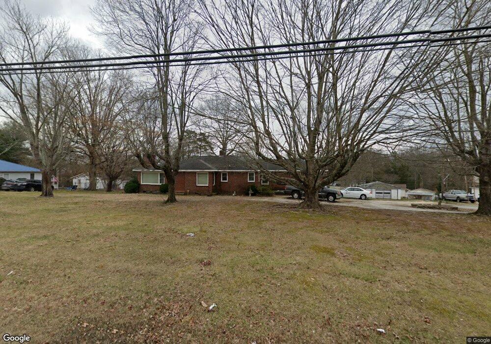
708 Liberty Rd High Point, NC 27263
Greater High Point NeighborhoodEstimated Value: $190,000 - $243,000
3
Beds
2
Baths
1,202
Sq Ft
$181/Sq Ft
Est. Value
About This Home
This home is located at 708 Liberty Rd, High Point, NC 27263 and is currently estimated at $217,206, approximately $180 per square foot. 708 Liberty Rd is a home located in Guilford County with nearby schools including Allen Jay Elementary School, Southern Guilford Middle, and Southern Guilford High School.
Ownership History
Date
Name
Owned For
Owner Type
Purchase Details
Closed on
Dec 10, 2002
Sold by
Household Realty Corp
Bought by
Jarrett Troy L and Jarrett Shirley H
Current Estimated Value
Home Financials for this Owner
Home Financials are based on the most recent Mortgage that was taken out on this home.
Original Mortgage
$85,500
Outstanding Balance
$12,739
Interest Rate
5%
Mortgage Type
Purchase Money Mortgage
Estimated Equity
$204,467
Create a Home Valuation Report for This Property
The Home Valuation Report is an in-depth analysis detailing your home's value as well as a comparison with similar homes in the area
Home Values in the Area
Average Home Value in this Area
Purchase History
| Date | Buyer | Sale Price | Title Company |
|---|---|---|---|
| Jarrett Troy L | $95,000 | -- |
Source: Public Records
Mortgage History
| Date | Status | Borrower | Loan Amount |
|---|---|---|---|
| Open | Jarrett Troy L | $85,500 |
Source: Public Records
Tax History Compared to Growth
Tax History
| Year | Tax Paid | Tax Assessment Tax Assessment Total Assessment is a certain percentage of the fair market value that is determined by local assessors to be the total taxable value of land and additions on the property. | Land | Improvement |
|---|---|---|---|---|
| 2025 | $793 | $90,400 | $16,000 | $74,400 |
| 2024 | $793 | $90,400 | $16,000 | $74,400 |
| 2023 | $793 | $90,400 | $16,000 | $74,400 |
| 2022 | $793 | $90,400 | $16,000 | $74,400 |
| 2021 | $668 | $76,200 | $16,000 | $60,200 |
| 2020 | $668 | $76,200 | $16,000 | $60,200 |
| 2019 | $668 | $76,200 | $0 | $0 |
| 2018 | $665 | $76,200 | $0 | $0 |
| 2017 | $645 | $76,200 | $0 | $0 |
| 2016 | $641 | $73,300 | $0 | $0 |
| 2015 | $645 | $73,300 | $0 | $0 |
| 2014 | $652 | $73,300 | $0 | $0 |
Source: Public Records
Map
Nearby Homes
- 1846 Sechrest Cir
- 1103 Pegram Ave
- 2716 Allen Jay Rd
- 2616 Ingram Rd
- 510 Aldridge Rd
- 2708 Ernest St
- 706 E Fairfield Rd
- 10812, 10822, 10828 N Main St
- 914 Nance Ave
- 10844 N Main St
- 600 E Fairfield Rd
- 302 Brittany Way
- 1640 Kersey Valley Rd
- 926 Norton St
- 3813 Salisbury St
- 209 Rivermeade Dr
- 921 Norton St
- 512 Dale St
- 201 Rivermeade Dr
- 1843 Weant Rd
- 712 Liberty Rd
- 113 Brookdale Dr
- 704 Liberty Rd
- 201 Brookdale Dr
- 109 Brookdale Dr
- 711 Liberty Rd
- 203 Brookdale Dr
- 205 Brookdale Dr
- 715 Liberty Rd
- 716 Liberty Rd
- 662 Ashland St
- 639 Liberty Rd
- 703 Ashland St
- 114 Brookdale Dr
- 1508 Southtree Ln
- 1510 Southtree Ln
- 209 Brookdale Dr
- 1506 Southtree Ln
- 202 Brookdale Dr
- 1516 Southtree Ln