Estimated Value: $290,243 - $307,000
5
Beds
3
Baths
2,271
Sq Ft
$131/Sq Ft
Est. Value
About This Home
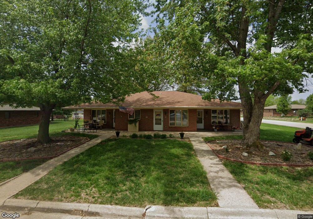
This home is located at 709 Abraham St, Firth, NE 68358 and is currently estimated at $298,622, approximately $131 per square foot. 709 Abraham St is a home located in Lancaster County with nearby schools including Norris Elementary School, Norris Middle School, and Norris High School.
Ownership History
Date
Name
Owned For
Owner Type
Purchase Details
Closed on
Sep 19, 2012
Sold by
Lincoln Federal Savings Bank Of Nebrask
Bought by
Maler Lee E and Maler Norma J
Current Estimated Value
Create a Home Valuation Report for This Property
The Home Valuation Report is an in-depth analysis detailing your home's value as well as a comparison with similar homes in the area
Home Values in the Area
Average Home Value in this Area
Purchase History
| Date | Buyer | Sale Price | Title Company |
|---|---|---|---|
| Maler Lee E | -- | None Available |
Source: Public Records
Tax History Compared to Growth
Tax History
| Year | Tax Paid | Tax Assessment Tax Assessment Total Assessment is a certain percentage of the fair market value that is determined by local assessors to be the total taxable value of land and additions on the property. | Land | Improvement |
|---|---|---|---|---|
| 2025 | $1,393 | $301,400 | $40,500 | $260,900 |
| 2024 | $1,393 | $236,600 | $40,500 | $196,100 |
| 2023 | $2,176 | $236,600 | $40,500 | $196,100 |
| 2022 | $3,712 | $195,100 | $27,000 | $168,100 |
| 2021 | $2,203 | $195,100 | $27,000 | $168,100 |
| 2020 | $1,870 | $159,100 | $27,000 | $132,100 |
| 2019 | $1,655 | $144,700 | $27,000 | $117,700 |
| 2018 | $1,680 | $144,700 | $27,000 | $117,700 |
| 2017 | $1,535 | $132,400 | $27,000 | $105,400 |
| 2016 | $1,539 | $132,400 | $27,000 | $105,400 |
| 2015 | $1,543 | $132,400 | $27,000 | $105,400 |
| 2014 | $1,610 | $132,900 | $27,000 | $105,900 |
| 2013 | -- | $132,900 | $27,000 | $105,900 |
Source: Public Records
Map
Nearby Homes
- 25401 S 82nd St
- 7900 Bowman Cir
- 6500 Princeton Rd
- 2212 S 96th Rd
- 9929 Springlake Ln N
- 22475 S 110th St
- 11101 Panama Rd
- 21101 S 96th St
- 1712 E 12th St
- 20.44 acres Pella Rd
- 1600 Pella Rd
- 10000 Wagon Train Rd
- 0 Hwy 77 & W 4th St
- 218 Chestnut St
- 330 W 3rd St
- 1254 Tuscan Trail
- 1164 Tuscan Trail
- 1812 E 12th St
- 19720 Long View Ln
- 19735 Ridgecrest Rd
- 709 Abraham St Unit 706
- 703 Abraham St
- 710 Russell St
- 710 Russell St
- 710 Russel
- 706 Russell St
- 308 E 8th St
- 310 E 7th St
- 802 Russell Cir
- 702 Abraham St
- 702 Russell St
- 402 E 7th St
- 804 Russell Cir
- 709 Russell St
- 801 Russell Cir
- 701 Russell St
- 205 E 8th St
- 806 Russell Cir
- 803 Russell Cir
- 609 Abraham St