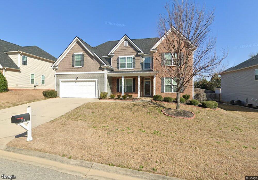
709 Coventry Ave Grovetown, GA 30813
Estimated Value: $435,484 - $457,000
4
Beds
4
Baths
3,835
Sq Ft
$117/Sq Ft
Est. Value
About This Home
This home is located at 709 Coventry Ave, Grovetown, GA 30813 and is currently estimated at $446,871, approximately $116 per square foot. 709 Coventry Ave is a home located in Columbia County with nearby schools including Baker Place Elementary School, Columbia Middle School, and Grovetown High School.
Ownership History
Date
Name
Owned For
Owner Type
Purchase Details
Closed on
Jul 25, 2011
Sold by
Ivey Res Llc
Bought by
Mccall Judith P
Current Estimated Value
Home Financials for this Owner
Home Financials are based on the most recent Mortgage that was taken out on this home.
Original Mortgage
$243,821
Outstanding Balance
$167,821
Interest Rate
4.52%
Mortgage Type
VA
Estimated Equity
$279,050
Purchase Details
Closed on
Apr 28, 2011
Sold by
Euchee Forest Llc
Bought by
Ivey Res Llc
Create a Home Valuation Report for This Property
The Home Valuation Report is an in-depth analysis detailing your home's value as well as a comparison with similar homes in the area
Home Values in the Area
Average Home Value in this Area
Purchase History
| Date | Buyer | Sale Price | Title Company |
|---|---|---|---|
| Mccall Judith P | $238,700 | -- | |
| Mccall Judith P | $238,690 | -- | |
| Ivey Res Llc | $44,000 | -- | |
| Ivey Residential Llc | $44,000 | -- |
Source: Public Records
Mortgage History
| Date | Status | Borrower | Loan Amount |
|---|---|---|---|
| Open | Mccall Judith P | $243,821 | |
| Closed | Mccall Judith P | $243,821 |
Source: Public Records
Tax History Compared to Growth
Tax History
| Year | Tax Paid | Tax Assessment Tax Assessment Total Assessment is a certain percentage of the fair market value that is determined by local assessors to be the total taxable value of land and additions on the property. | Land | Improvement |
|---|---|---|---|---|
| 2024 | $4,426 | $176,797 | $27,204 | $149,593 |
| 2023 | $4,426 | $177,360 | $27,204 | $150,156 |
| 2022 | $3,974 | $152,657 | $24,104 | $128,553 |
| 2021 | $3,621 | $132,986 | $20,904 | $112,082 |
| 2020 | $3,671 | $132,077 | $21,004 | $111,073 |
| 2019 | $3,424 | $123,186 | $21,904 | $101,282 |
| 2018 | $3,480 | $124,747 | $22,004 | $102,743 |
| 2017 | $3,472 | $124,046 | $20,304 | $103,742 |
| 2016 | $3,129 | $115,914 | $19,780 | $96,134 |
| 2015 | $3,019 | $111,616 | $18,380 | $93,236 |
| 2014 | $2,867 | $104,706 | $18,380 | $86,326 |
Source: Public Records
Map
Nearby Homes
- 1221 Absolon Ct
- 1218 Absolon Ct
- 4044 Ellington Dr
- 1214 Absolon Ct
- 4010 Ellington Dr
- 1986 Kenlock Dr
- 4061 Ellington Dr
- 655 Aberdeen Cir
- 337 Brentford Ave
- 278 Palamon Dr
- 220 Havelock Dr
- 305 Brentford Ave
- 832 Williford Run Dr
- 139 Broadleaf Trail
- 203 Havelock Dr
- 118 Broadleaf Trail
- 674 Shipley Ave
- 272 Seaton Ave
- 269 Seaton Ave
- 208 Dripping Rock Pass
- 711 Coventry Ave
- 707 Coventry Ave
- 1233 Absolon Ct
- 713 Coventry Ave
- 1231 Absolon Ct
- 706 Coventry Ave
- 708 Coventry Ave
- 4032 Ellington Dr
- 710 Coventry Ave
- 1229 Absolon Ct
- 715 Coventry Ave
- 4040 Ellington Dr
- 704 Coventry Ave
- 704 Coventry Ave
- 1228 Absolon Ct
- 712 Coventry Ave
- 4042 Ellington Dr
- 700 Coventry Ave
- 1225 Absolon Ct
- 717 Coventry Ave