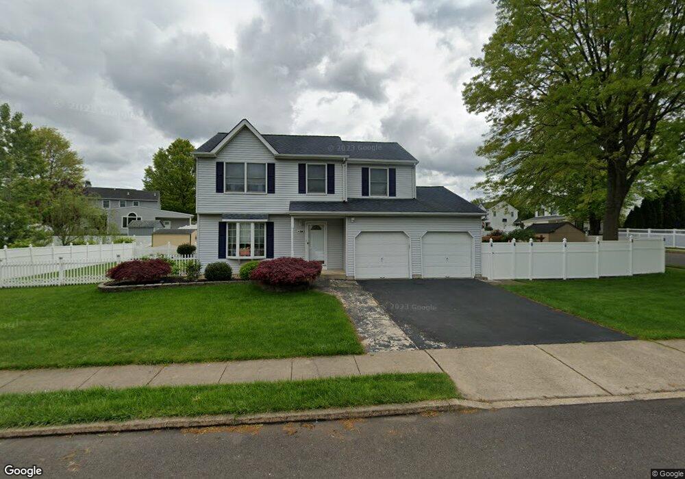
709 Highpointe Cir Langhorne, PA 19047
Estimated Value: $496,198 - $651,000
3
Beds
3
Baths
1,588
Sq Ft
$357/Sq Ft
Est. Value
About This Home
This home is located at 709 Highpointe Cir, Langhorne, PA 19047 and is currently estimated at $567,300, approximately $357 per square foot. 709 Highpointe Cir is a home located in Bucks County with nearby schools including Hoover Elementary School, Maple Point Middle School, and Neshaminy High School.
Ownership History
Date
Name
Owned For
Owner Type
Purchase Details
Closed on
May 1, 2010
Sold by
Phadke Shivaji and Phadke Isa S
Bought by
Chen Wendy M
Current Estimated Value
Home Financials for this Owner
Home Financials are based on the most recent Mortgage that was taken out on this home.
Original Mortgage
$244,800
Interest Rate
4.4%
Mortgage Type
New Conventional
Purchase Details
Closed on
Aug 29, 2003
Sold by
White Earl F
Bought by
Phadke Shivaji and Phadke Isa S
Home Financials for this Owner
Home Financials are based on the most recent Mortgage that was taken out on this home.
Original Mortgage
$240,000
Interest Rate
6.31%
Mortgage Type
Purchase Money Mortgage
Purchase Details
Closed on
Sep 4, 2002
Sold by
White Earl F and White Barbara A
Bought by
White Earl F
Create a Home Valuation Report for This Property
The Home Valuation Report is an in-depth analysis detailing your home's value as well as a comparison with similar homes in the area
Home Values in the Area
Average Home Value in this Area
Purchase History
| Date | Buyer | Sale Price | Title Company |
|---|---|---|---|
| Chen Wendy M | $306,000 | None Available | |
| Phadke Shivaji | $300,000 | -- | |
| White Earl F | -- | -- |
Source: Public Records
Mortgage History
| Date | Status | Borrower | Loan Amount |
|---|---|---|---|
| Previous Owner | Chen Wendy M | $244,800 | |
| Previous Owner | Phadke Shivaji | $240,000 |
Source: Public Records
Tax History
| Year | Tax Paid | Tax Assessment Tax Assessment Total Assessment is a certain percentage of the fair market value that is determined by local assessors to be the total taxable value of land and additions on the property. | Land | Improvement |
|---|---|---|---|---|
| 2025 | $6,540 | $30,040 | $5,200 | $24,840 |
| 2024 | $6,540 | $30,040 | $5,200 | $24,840 |
| 2023 | $6,436 | $30,040 | $5,200 | $24,840 |
| 2022 | $6,267 | $30,040 | $5,200 | $24,840 |
| 2021 | $6,267 | $30,040 | $5,200 | $24,840 |
| 2020 | $6,192 | $30,040 | $5,200 | $24,840 |
| 2019 | $6,054 | $30,040 | $5,200 | $24,840 |
| 2018 | $5,943 | $30,040 | $5,200 | $24,840 |
| 2017 | $5,791 | $30,040 | $5,200 | $24,840 |
| 2016 | $5,791 | $30,040 | $5,200 | $24,840 |
| 2015 | $5,980 | $30,040 | $5,200 | $24,840 |
| 2014 | $5,980 | $30,040 | $5,200 | $24,840 |
Source: Public Records
Map
Nearby Homes
- 41 Pleasant Ave
- 937 Highpointe Cir
- 732 Sparrow Ln
- 786 E Parker St Unit C1
- 866 Hulmeville Rd
- 956 Duxbury Dr
- 827 Hulmeville Rd
- 858 Avenue E Unit E
- 3225 Ethan Allen Ct
- 0 Prospect Ave
- 6301 Powder Horn Ct
- 56 W Lincoln Hwy
- 1420 Super Hwy
- 711 Bellevue Ave
- 706 Fox Ct
- 3071 Gilbert Dr
- 455 Jefferson Ave
- 428 Madison Ave
- 2548 Nashua Rd
- 2524 Valley View Rd
- 654 Crescent St
- 719 Highpointe Cir
- 698 Highpointe Cir
- 708 Highpointe Cir
- 250 Brittany Dr
- 702 Highpointe Cir
- 260 Brittany Dr
- 659 Crescent St
- 714 Highpointe Cir
- 729 Highpointe Cir
- 240 Brittany Dr
- 699 Highpointe Cir
- 720 Highpointe Cir
- 692 Highpointe Cir
- 655 Crescent St
- 638 Crescent St
- 259 Brittany Dr
- 726 Highpointe Cir
- 230 Brittany Dr
- 686 Highpointe Cir
Your Personal Tour Guide
Ask me questions while you tour the home.