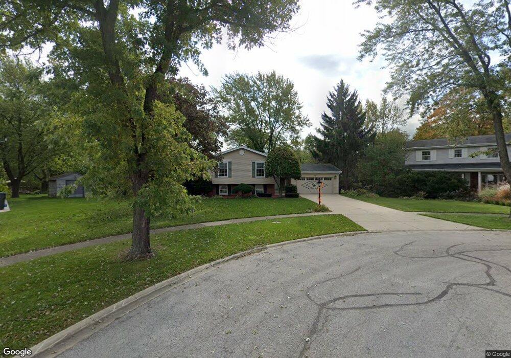
709 Maple Ln Darien, IL 60561
Estimated Value: $474,000 - $494,000
4
Beds
2
Baths
2,472
Sq Ft
$194/Sq Ft
Est. Value
About This Home
This home is located at 709 Maple Ln, Darien, IL 60561 and is currently estimated at $480,206, approximately $194 per square foot. 709 Maple Ln is a home located in DuPage County with nearby schools including Mark Delay School, Lace Elementary School, and Eisenhower Jr High School.
Ownership History
Date
Name
Owned For
Owner Type
Purchase Details
Closed on
Oct 23, 2025
Sold by
Wilk Katherine S
Bought by
Katherine S Wilk Declaration Of Trust and Wilk
Current Estimated Value
Purchase Details
Closed on
Jul 25, 1995
Sold by
Kure Clarence M
Bought by
Wilk William K and Wilk Katherine S
Home Financials for this Owner
Home Financials are based on the most recent Mortgage that was taken out on this home.
Original Mortgage
$60,000
Interest Rate
7.56%
Create a Home Valuation Report for This Property
The Home Valuation Report is an in-depth analysis detailing your home's value as well as a comparison with similar homes in the area
Home Values in the Area
Average Home Value in this Area
Purchase History
We collect this data history from publicly available records. To have your information removed, we recommend requesting removal directly through your county’s website.
| Date | Buyer | Sale Price | Title Company |
|---|---|---|---|
| Katherine S Wilk Declaration Of Trust | -- | None Listed On Document | |
| Wilk William K | $176,666 | Attorneys Title Guaranty Fun |
Source: Public Records
Mortgage History
We collect this data history from publicly available records. To have your information removed, we recommend requesting removal directly through your county’s website.
| Date | Status | Borrower | Loan Amount |
|---|---|---|---|
| Previous Owner | Wilk William K | $60,000 |
Source: Public Records
Tax History
| Year | Tax Paid | Tax Assessment Tax Assessment Total Assessment is a certain percentage of the fair market value that is determined by local assessors to be the total taxable value of land and additions on the property. | Land | Improvement |
|---|---|---|---|---|
| 2024 | $9,247 | $159,515 | $75,841 | $83,674 |
| 2023 | $8,866 | $146,640 | $69,720 | $76,920 |
| 2022 | $8,880 | $143,640 | $68,290 | $75,350 |
| 2021 | $8,538 | $142,000 | $67,510 | $74,490 |
| 2020 | $8,418 | $139,180 | $66,170 | $73,010 |
| 2019 | $8,126 | $133,540 | $63,490 | $70,050 |
| 2018 | $7,641 | $127,160 | $63,110 | $64,050 |
| 2017 | $7,555 | $122,360 | $60,730 | $61,630 |
| 2016 | $7,346 | $116,780 | $57,960 | $58,820 |
| 2015 | $7,223 | $109,870 | $54,530 | $55,340 |
| 2014 | $6,876 | $103,780 | $53,020 | $50,760 |
| 2013 | $6,645 | $103,290 | $52,770 | $50,520 |
Source: Public Records
Map
Nearby Homes
- 6914 Richmond Ave
- 538 Maple Ln
- 6922 Sierra Dr
- 7216 Leonard Dr
- 430 71st St
- 7413 Brookdale Dr Unit 208
- 7413 Brookdale Dr Unit 212
- 7113 Clarendon Hills Rd
- 1076 Larkspur Ln Unit C42C
- 1139 James Peter Ct
- 1120 Ponderosa Ct
- 1061 Sean Cir
- 5828 Clarendon Hills Rd
- 6136 Bentley Ave
- 321 Janet Ave
- 221 69th St
- 344 Sheridan Dr Unit 1C
- 825 Walnut Dr
- 17 Peach Tree Ln
- 7700 Apple Tree Ln
Your Personal Tour Guide
Ask me questions while you tour the home.