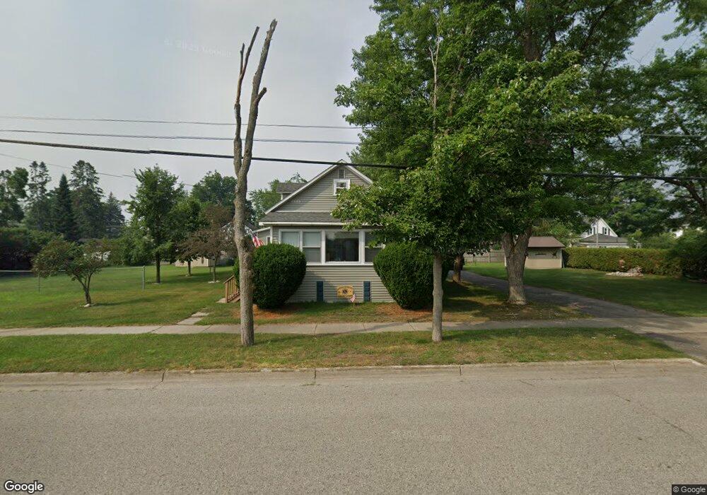
709 Maple St Grayling, MI 49738
Estimated Value: $142,000 - $166,000
Studio
--
Bath
1,288
Sq Ft
$117/Sq Ft
Est. Value
About This Home
This home is located at 709 Maple St, Grayling, MI 49738 and is currently estimated at $150,968, approximately $117 per square foot. 709 Maple St is a home located in Crawford County with nearby schools including Grayling Elementary School, Grayling Middle School, and Grayling High School.
Ownership History
Date
Name
Owned For
Owner Type
Purchase Details
Closed on
Sep 23, 2021
Sold by
Rakoczy Ronald J
Bought by
Rakoczy Joseph and Rakoczy Kathy
Current Estimated Value
Purchase Details
Closed on
May 15, 1997
Sold by
Rakoczy Ronald J
Bought by
Rakoczy Ronald and Carolyn Trst
Purchase Details
Closed on
Jun 23, 1994
Purchase Details
Closed on
Jun 10, 1985
Sold by
Rakoczy Carolyn Suffield
Bought by
Rokoczy Ronald J and Rokoczy Carolyn S
Purchase Details
Closed on
Jun 15, 1982
Sold by
White Joseph P Per Rep
Bought by
Suffield Carolyn S
Purchase Details
Closed on
Oct 18, 1976
Sold by
Carlson Russell A and Carlson Madelyn L
Bought by
White Dora
Create a Home Valuation Report for This Property
The Home Valuation Report is an in-depth analysis detailing your home's value as well as a comparison with similar homes in the area
Home Values in the Area
Average Home Value in this Area
Purchase History
| Date | Buyer | Sale Price | Title Company |
|---|---|---|---|
| Rakoczy Joseph | $85,000 | -- | |
| Rakoczy Ronald | -- | -- | |
| -- | $27,000 | -- | |
| Rokoczy Ronald J | -- | -- | |
| Suffield Carolyn S | $27,000 | -- | |
| White Dora | $25,100 | -- |
Source: Public Records
Tax History
| Year | Tax Paid | Tax Assessment Tax Assessment Total Assessment is a certain percentage of the fair market value that is determined by local assessors to be the total taxable value of land and additions on the property. | Land | Improvement |
|---|---|---|---|---|
| 2025 | $1,733 | $63,500 | $4,200 | $59,300 |
| 2024 | $1,693 | $59,200 | $4,200 | $55,000 |
| 2023 | $1,619 | $52,000 | $4,200 | $47,800 |
| 2022 | $1,539 | $35,900 | $4,200 | $31,700 |
| 2021 | $1,238 | $33,400 | $4,200 | $29,200 |
| 2020 | $1,222 | $32,500 | $4,200 | $28,300 |
| 2019 | $1,195 | $31,600 | $4,200 | $27,400 |
| 2018 | $1,173 | $27,500 | $4,200 | $23,300 |
| 2017 | $969 | $27,800 | $4,200 | $23,600 |
| 2016 | $961 | $25,700 | $4,200 | $21,500 |
| 2015 | -- | $25,700 | $0 | $0 |
| 2014 | -- | $26,700 | $0 | $0 |
| 2013 | -- | $28,400 | $0 | $0 |
Source: Public Records
Map
Nearby Homes
- 809 Maple St
- 704 Elm St
- 1024 S I-75 Business Loop
- Lot 4 Erie St
- 403 Erie St
- 1107 Ogemaw St
- 1205 E Michigan Ave
- 205 Park St
- 309 Lillian St
- 000 W M-72 Hwy
- 110 State St
- V/L L71-75 Evergreen Dr
- 4593 Orbit Dr
- 5973 W M-72 Hwy
- V/L Lot 9 Norseman Dr
- V/L Lot 2 Norseman Dr
- V/L Lot 10 Norseman Dr
- V/L Lot 1 Norseman Dr
- 208 Crestwood Dr
- 6960 Trem Pal Rd
Your Personal Tour Guide
Ask me questions while you tour the home.