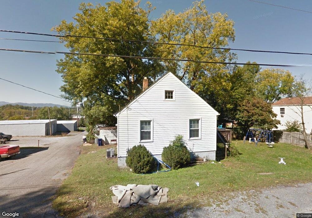
709 S Pollard St Vinton, VA 24179
Estimated Value: $94,000 - $177,000
2
Beds
1
Bath
624
Sq Ft
$228/Sq Ft
Est. Value
About This Home
This home is located at 709 S Pollard St, Vinton, VA 24179 and is currently estimated at $142,542, approximately $228 per square foot. 709 S Pollard St is a home located in Roanoke County with nearby schools including W.E. Cundiff Elementary School, William Byrd Middle School, and William Byrd High School.
Ownership History
Date
Name
Owned For
Owner Type
Purchase Details
Closed on
May 5, 2023
Sold by
Thompson Richard D and Thompson Linda R
Bought by
Thompson Rental Property Llc
Current Estimated Value
Create a Home Valuation Report for This Property
The Home Valuation Report is an in-depth analysis detailing your home's value as well as a comparison with similar homes in the area
Home Values in the Area
Average Home Value in this Area
Purchase History
| Date | Buyer | Sale Price | Title Company |
|---|---|---|---|
| Thompson Rental Property Llc | $60,000 | None Listed On Document |
Source: Public Records
Tax History Compared to Growth
Tax History
| Year | Tax Paid | Tax Assessment Tax Assessment Total Assessment is a certain percentage of the fair market value that is determined by local assessors to be the total taxable value of land and additions on the property. | Land | Improvement |
|---|---|---|---|---|
| 2025 | $1,098 | $106,600 | $36,600 | $70,000 |
| 2024 | $1,066 | $102,500 | $34,000 | $68,500 |
| 2023 | $1,038 | $97,900 | $31,500 | $66,400 |
| 2022 | $909 | $83,400 | $26,400 | $57,000 |
| 2021 | $790 | $72,500 | $23,000 | $49,500 |
| 2020 | $723 | $66,300 | $20,400 | $45,900 |
| 2019 | $686 | $62,900 | $18,700 | $44,200 |
| 2018 | $667 | $62,200 | $18,700 | $43,500 |
| 2017 | $667 | $61,200 | $18,700 | $42,500 |
| 2016 | $653 | $59,900 | $17,900 | $42,000 |
| 2015 | $638 | $58,500 | $17,000 | $41,500 |
| 2014 | $632 | $58,000 | $17,000 | $41,000 |
Source: Public Records
Map
Nearby Homes
- 125 W Virginia Ave
- 216 W Augusta Ave
- 234 Raleigh Ave
- 116 Cedar Ave
- 216 Franklin Ave
- 406 E Augusta Ave
- 411 Raleigh Ave
- TBD Chestnut St
- 0 Chestnut St
- 425 Jefferson Ave
- 515 Cedar Ave
- 535 Jefferson Ave
- 177 Highland Rd
- 705 E Virginia Ave
- 2107 Kenwood Blvd SE
- 646 E Augusta Ave
- 2052 Kenwood Blvd SE
- 2315 Vale Ave
- 2248 Vale Ave NE
- 2027 Clinton Ave SE
- 105 W Augusta Ave
- 103 W Augusta Ave Unit 105
- 121 W Augusta Ave
- 725 S Pollard St
- 123 W Augusta Ave Unit 125
- 702 S Pollard St
- 708 S Pollard St
- 100 Raleigh Ave
- 127 W Augusta Ave
- 104 Raleigh Ave
- 112 W Augusta Ave
- 809 S Pollard St
- 615 S Pollard St Unit 625
- 120 W Augusta Ave
- 626 S Pollard St
- 720 2nd St
- 108 Raleigh Ave
- 124 W Augusta Ave
- 141 W Augusta Ave
- 622 S Pollard St