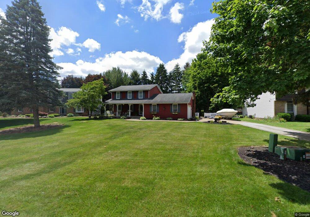
7092 Barnstable Cir NW Canton, OH 44718
Lake Cable NeighborhoodEstimated Value: $340,013 - $445,000
3
Beds
2
Baths
2,002
Sq Ft
$188/Sq Ft
Est. Value
About This Home
This home is located at 7092 Barnstable Cir NW, Canton, OH 44718 and is currently estimated at $375,503, approximately $187 per square foot. 7092 Barnstable Cir NW is a home located in Stark County with nearby schools including Sauder Elementary School, Jackson Memorial Middle School, and Jackson High School.
Ownership History
Date
Name
Owned For
Owner Type
Purchase Details
Closed on
Apr 23, 2001
Sold by
Fuller Mark J and Fuller Sharyn C
Bought by
Arrington Anthony and Arrington Pamela
Current Estimated Value
Home Financials for this Owner
Home Financials are based on the most recent Mortgage that was taken out on this home.
Original Mortgage
$137,600
Outstanding Balance
$58,111
Interest Rate
9.75%
Mortgage Type
Purchase Money Mortgage
Estimated Equity
$317,392
Purchase Details
Closed on
May 5, 1992
Create a Home Valuation Report for This Property
The Home Valuation Report is an in-depth analysis detailing your home's value as well as a comparison with similar homes in the area
Home Values in the Area
Average Home Value in this Area
Purchase History
| Date | Buyer | Sale Price | Title Company |
|---|---|---|---|
| Arrington Anthony | $172,000 | -- | |
| -- | $122,000 | -- |
Source: Public Records
Mortgage History
| Date | Status | Borrower | Loan Amount |
|---|---|---|---|
| Open | Arrington Anthony | $137,600 | |
| Closed | Arrington Anthony | $34,400 |
Source: Public Records
Tax History
| Year | Tax Paid | Tax Assessment Tax Assessment Total Assessment is a certain percentage of the fair market value that is determined by local assessors to be the total taxable value of land and additions on the property. | Land | Improvement |
|---|---|---|---|---|
| 2025 | -- | $104,480 | $47,250 | $57,230 |
| 2024 | -- | $104,480 | $47,250 | $57,230 |
| 2023 | $4,074 | $79,490 | $35,980 | $43,510 |
| 2022 | $4,057 | $79,490 | $35,980 | $43,510 |
| 2021 | $4,072 | $79,490 | $35,980 | $43,510 |
| 2020 | $3,788 | $67,940 | $31,050 | $36,890 |
| 2019 | $3,663 | $67,940 | $31,050 | $36,890 |
| 2018 | $3,685 | $67,940 | $31,050 | $36,890 |
| 2017 | $3,593 | $63,000 | $28,350 | $34,650 |
| 2016 | $3,507 | $61,040 | $28,350 | $32,690 |
| 2015 | $3,549 | $61,040 | $28,350 | $32,690 |
| 2014 | $1,420 | $56,220 | $26,120 | $30,100 |
| 2013 | $1,684 | $56,220 | $26,120 | $30,100 |
Source: Public Records
Map
Nearby Homes
- 5820 Kildare Cir NW
- 5412 Downingsgate Cir NW
- 6281 Champion Ave NW
- 6180 Drexel St NW
- 6460 Saint Augustine Dr NW Unit IV19
- 6272 Doral Dr NW
- 5433 Fleetwood Ave NW
- 6269 Drexel St NW
- 7374 Celina St NW
- 6519 Lorraine Ave NW
- 5155 Fleetwood Ave NW
- 8079 Windward Trace Cir NW
- 6301 Palmer Dr NW
- 7412 Klingston St NW
- 6882 Glengarry Ave NW
- 5913 Fulton Dr NW
- 6686 Hogan Way NW
- 5036 West Blvd NW
- 6733 Dale Ave NW
- 5500 Nettlecreek Ave NW
- 7100 Barnstable Cir NW
- 7084 Barnstable Cir NW
- 5606 Foxboro Ave NW
- 7083 Barnstable Cir NW
- 7109 Barnstable Cir NW
- 5584 Foxboro Ave NW
- 7074 Barnstable Cir NW
- 5566 Foxboro Ave NW
- 5640 Foxboro Ave NW
- 7057 Militia Hill St NW
- 5546 Foxboro Ave NW
- 7053 Militia Hill St NW
- 7098 Andiron Cir NW
- 7067 Fulton Dr NW
- 7136 Andiron Cir NW
- 7076 Militia Hill St NW
- 7156 Andiron Cir NW
- 5599 Foxboro Ave NW
- 5528 Foxboro Ave NW
- 5617 Foxboro Ave NW
Your Personal Tour Guide
Ask me questions while you tour the home.