NOT LISTED FOR SALE

71 Curtis Pond Rd Waymart, PA 18472

Estimated Value: $729,000

98 Acres
$7,439 Price per Acre
4,268,880 Sq Ft Lot

Last Sold October 29, 2021

Last sale price $495,000

Est. 47% increase in value since last sale

Current estimated payment $4,586/month

32 Days on Market

Highlights

  • 98 Acre Lot
  • Home fronts a stream
  • Level Lot
  • Wooded Lot

About This Lot

As of October 2021

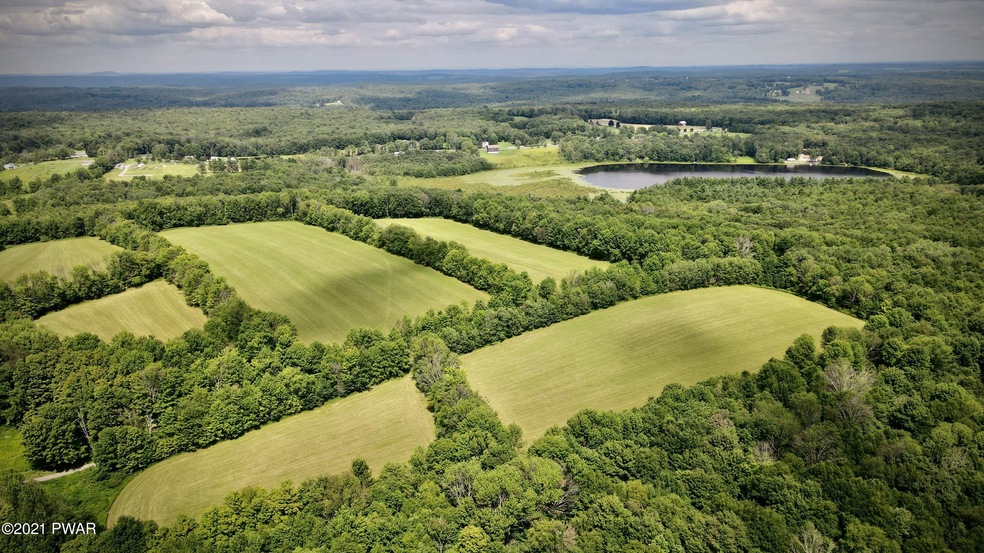
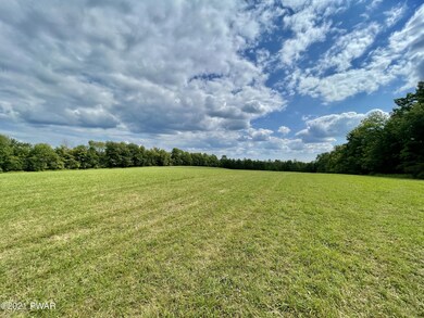
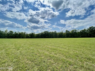
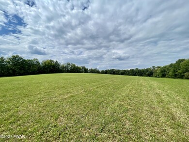
SECLUDED SANCTUARY! Follow the winding road up to see the many ancient trees creating a canopy of shade while listening to babbling creek on either side of you running over rocks& roots. As the sunlight emerges, there is a clearing of grass where a house once stood. There is a capped off well dug in the 1990's. This site provides an amazing view of the fields, trees & nature welcoming you to an oasis that will make your heart soar like the many birds flying by. The fields have been farmed to preserve their nutrients & overall health & are naturally bordered by thin rows of trees. While walking the property you can find cherry & apple orchards. Rock walls are found throughout the boundaries and in the woods. Forever home? Glamping site? Hunting Retreat? You choose! The time is now!

Last Agent to Sell the Property

Maxwell Stevens

Berkshire Hathaway HomeServices Pocono Real Estate Hawley License #RS349255 Listed on: 08/06/2021

Berkshire Hathaway HomeServices Pocono Real Estate Hawley

Last Buyer's Agent

NON-MEMBER

NON-MEMBER OFFICE

Property Details

Property Type

  • Land

Est. Annual Taxes

  • $3,856

Year Built

  • 1900

Lot Details

  • 98 Acre Lot
  • Home fronts a stream
  • Level Lot
  • Cleared Lot
  • Wooded Lot

Utilities

  • Well
  • Sewer Not Available

Listing and Financial Details

  • Assessor Parcel Number 24-0-0261-0045

Property Details

Property Type

Land

Est. Annual Taxes

$3,856

Year Built

1900

Lot Details

0

Listing Details

  • Directions: From Rt 590 Turn down Oweego Tpke then trun left on Davitt Rd and then right on Curtis Pond Rd. Land is down .6 miles on either side of the road
  • Lot Size Acres: 98
  • Prop. Type: Land
  • Subdivision Name: None
  • Reso Property Sub Type: Unimproved Land
  • ResoLotFeatures: Cleared, Wooded, Rolling Slope, Level
  • Road Frontage Type: City Street
  • Road Surface Type: Other
  • Water Body Name: None
  • GasRightsReserved: None
  • SchoolTaxAmount: 2673.30
  • Special Features: None
  • Property Sub Type: LotsLands
  • Year Built (Public Record): 1900

Interior Features

  • Possible Use: Agricultural, Residential

Exterior Features

  • Waterfront Features: Stream
  • Waterfront: Yes
  • Builder: Unknown

Utilities

  • Utilities: Electricity Available, Sewer Not Available
  • Water Source: Other, Well, See Remarks

Condo/Co-op/Association

  • Community Features: None

Schools

  • Junior High Dist: Western Wayne Area

Lot Info

  • Current Use: Single Family
  • Development Status: Raw Land
  • Number Of Lots: 1
  • Parcel #: 24-0-0261-0045
  • Zoning Description: Residential

Tax Info

  • Tax Annual Amount: 3856.02
  • Tax Book Number: R-4789/184

Ownership History

Date Name Owned For Owner Type

Purchase Details

Listed on
Aug 6, 2021
Closed on
Oct 19, 2021
Sold by
Stonely Karen M Syp and Estat Of Joyce H Stonely
Bought by
Zeng Yi and Fernandez Joseph Charles
Seller's Agent
Maxwell Stevens
Berkshire Hathaway HomeServices Pocono Real Estate Hawley
Buyer's Agent
NON-MEMBER
NON-MEMBER OFFICE
List Price
$490,000
Sold Price
$495,000
Premium/Discount to List
$5,000
1.02%
Total Days on Market
32
Current Estimated Value
$729,000

Home Financials for this Owner

Home Financials are based on the most recent Mortgage that was taken out on this home.
Estimated Appreciation
$234,000
Avg. Annual Appreciation
11.27%

Purchase Details

Closed on
Nov 9, 2017
Sold by
Palmer Russell M and Palmer Marie
Bought by
The Dime Bank
Source: Public Records

Range of Values:

Collateral Analytics

Collateral Analytics Collateral Analytics AVMs (Automated Valuation Model) employ a number of statistical approaches combined with neighborhood-specific comparable selection guarantees the most up-to-date and precise valuations.

Not Available

Collateral Analytics does not have data for the current month. Please view the chart for historical values.

ICE

ICE Mortgage Technology ICE Mortgage Technology’s AVM (Automated Valuation Model) is a state-of-the-art online residential property valuation tool that provides a quick and accurate estimate of the value of almost any home in the U.S.

Not Available

ICE Mortgage Technology does not have data for the current month. Please view the chart for historical values.

First American

First American First American Data & Analytics’ next-generation AVM combines unrivaled data assets with a blended ensemble of valuation models to produce highly accurate, reliable valuations you can trust.

Not Available

First American does not have data for the current month. Please view the chart for historical values.

Quantarium

Quantarium Quantarium’s valuation service, repeatedly proven the industry’s most accurate and comprehensive, is supercharged with a self-learning and auto-tuning AI engine that continually becomes smarter and more accurate as it processes daily inputs from the industry’s leading RE data lake.

Not Available

Quantarium does not have data for the current month. Please view the chart for historical values.

Average Value
Not Available
List Price
Sold Price
Create a Home Valuation Report for This Property
The Home Valuation Report is an in-depth analysis detailing your home's value as well as a comparison with similar homes in the area

Home Values in the Area

Source: Public Records

Average Home Value in this Area


Source: Public Records

Purchase History

Date Buyer Sale Price Title Company
Zeng Yi $495,000 Statewide Abstract Co Inc
The Dime Bank -- None Available
Source: Public Records

Property History

Date Event Price Change Sq Ft Price
10/29/2021 10/29/21 Sold $495,000 +1.0% --
09/07/2021 09/07/21 Pending -- -- --
08/06/2021 08/06/21 For Sale $490,000 -- --
Source: Pike/Wayne Association of REALTORS®

Tax History Compared to Growth

Source: Public Records

Tax History

Year Tax Paid Tax Assessment Tax Assessment Total Assessment is a certain percentage of the fair market value that is determined by local assessors to be the total taxable value of land and additions on the property. Land Improvement
2025 $5,931 $341,800 $130,400 $211,400
2024 $1,692 $102,200 $102,200 $0
2023 $5,880 $256,200 $256,200 $0
2022 $3,946 $154,200 $154,200 $0
2021 $3,856 $154,200 $154,200 $0
2020 $3,817 $154,200 $154,200 $0
2019 $3,623 $154,200 $154,200 $0
2018 $3,604 $154,200 $154,200 $0
2017 $0 $154,200 $154,200 $0
2016 $3,501 $154,200 $154,200 $0
2014 -- $154,200 $154,200 $0
Source: Public Records

Agents Affiliated with this Home

  • Section Image
See All Agents

Map

Source: Pike/Wayne Association of REALTORS®

MLS Number: PWB213109

Pike/Wayne Association of REALTORS®

APN: 027257