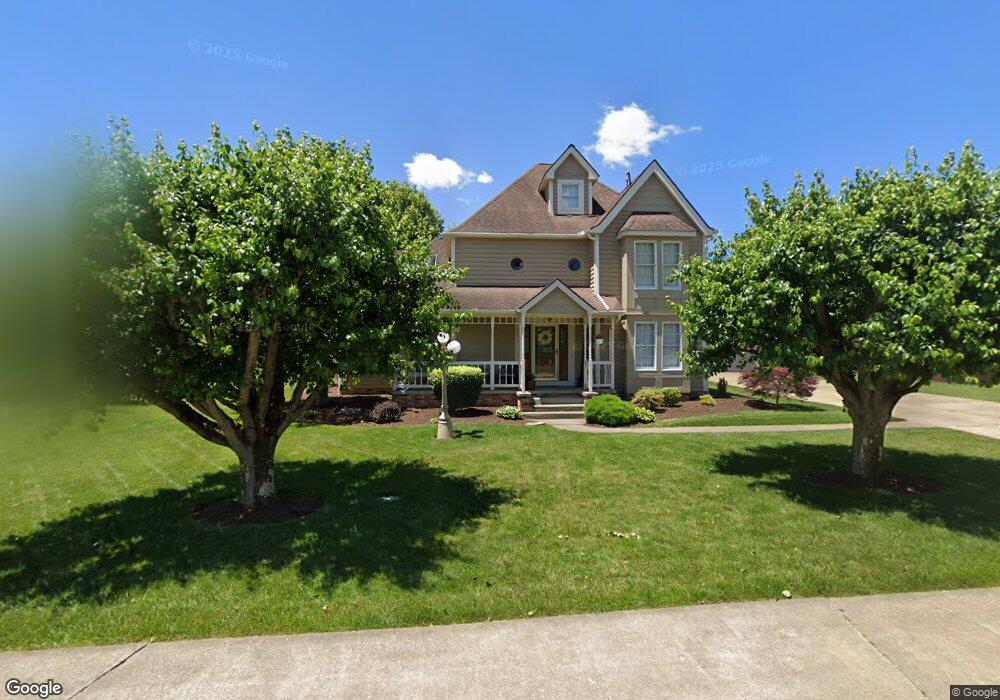
71 Garden Cir Bridgeport, WV 26330
Estimated Value: $398,000 - $593,000
4
Beds
3
Baths
2,949
Sq Ft
$164/Sq Ft
Est. Value
About This Home
This home is located at 71 Garden Cir, Bridgeport, WV 26330 and is currently estimated at $482,261, approximately $163 per square foot. 71 Garden Cir is a home located in Harrison County with nearby schools including Heritage Christian School and Dollie Hilll Christian Academy.
Ownership History
Date
Name
Owned For
Owner Type
Purchase Details
Closed on
Sep 13, 2011
Sold by
Odell Pamela K
Bought by
Sprouse Douglas B and Sprouse Kimberly J
Current Estimated Value
Home Financials for this Owner
Home Financials are based on the most recent Mortgage that was taken out on this home.
Original Mortgage
$245,000
Outstanding Balance
$168,334
Interest Rate
4.33%
Mortgage Type
New Conventional
Estimated Equity
$313,927
Purchase Details
Closed on
May 12, 2010
Sold by
Mchenry Donald M
Bought by
Odell Pamela K
Create a Home Valuation Report for This Property
The Home Valuation Report is an in-depth analysis detailing your home's value as well as a comparison with similar homes in the area
Home Values in the Area
Average Home Value in this Area
Purchase History
| Date | Buyer | Sale Price | Title Company |
|---|---|---|---|
| Sprouse Douglas B | $310,000 | None Available | |
| Odell Pamela K | $315,000 | None Available |
Source: Public Records
Mortgage History
| Date | Status | Borrower | Loan Amount |
|---|---|---|---|
| Open | Sprouse Douglas B | $245,000 |
Source: Public Records
Tax History Compared to Growth
Tax History
| Year | Tax Paid | Tax Assessment Tax Assessment Total Assessment is a certain percentage of the fair market value that is determined by local assessors to be the total taxable value of land and additions on the property. | Land | Improvement |
|---|---|---|---|---|
| 2024 | $3,970 | $243,240 | $33,180 | $210,060 |
| 2023 | $3,662 | $213,180 | $33,180 | $180,000 |
| 2022 | $3,251 | $211,560 | $33,180 | $178,380 |
| 2021 | $3,186 | $209,220 | $33,180 | $176,040 |
| 2020 | $3,125 | $206,760 | $33,180 | $173,580 |
| 2019 | $3,114 | $205,980 | $33,180 | $172,800 |
| 2018 | $3,067 | $203,580 | $33,180 | $170,400 |
| 2017 | $3,008 | $200,340 | $33,180 | $167,160 |
| 2016 | $2,933 | $197,220 | $33,180 | $164,040 |
| 2015 | $2,918 | $193,200 | $33,180 | $160,020 |
| 2014 | $2,879 | $190,740 | $33,180 | $157,560 |
Source: Public Records
Map
Nearby Homes
- 636 Easy St
- 125 Carriage Ln
- 100 Vista Dr
- 507 Willow Ln
- 501 Willow Ln
- 1251 Briercliff Rd Unit 66
- 1251 Briercliff Rd
- 125 Ashford Dr
- 129 Vista Dr
- 3 Millbrook Rd
- Lot 26 Lindale St
- 20 Meadow Ln
- 428 James St
- 502 Stout St
- 303 Lexington Cir
- 252 Sherwood Rd
- 0 Pearcy Ave
- 328 W Philadelphia Ave
- 220 Davisson St
- 216 Davisson St