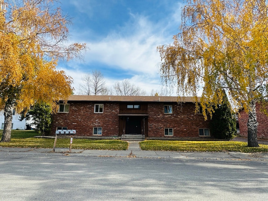
71 Hawthorn Ave Kalispell, MT 59901
Estimated payment $4,659/month
About This Home
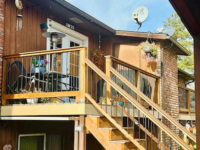
Attention investors! Offering a cash-flowing and desirable 4-plex in the heart of Kalispell. Centrally located, four 2-bed 1-bath units, fully rented with long-term renters, all on month-to-month leases. Each unit has their own laundry in unit. Washers and dryers belong to tenants. Several improvements have been made to building and to the units including new windows, new decks and vinyl plank flooring in 2 of the 4 units. *Roof is in process of being replaced* At asking price, this investment currently yields just under a 6% cap rate and with a slight rent increase to current market value would be just under 7%. Please see docs for 2024, 2025 and projected income and expense estimates. There will be no showings of the interiors of the units until offer has been accepted. Buyer may preview units during inspection period. Based on recent market activity, we expect this one won't last long!
Listing Agent
PureWest Real Estate - Kalispell License #RRE-RBS-LIC-118577 Listed on: 11/03/2025
Property Details
Home Type
- Multi-Family
Est. Annual Taxes
- $5,632
Year Built
- Built in 1977
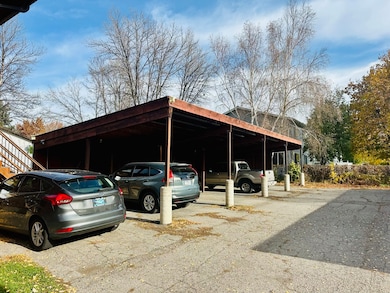
Parking
- 4 Carport Spaces
Home Design
- 3,960 Sq Ft Home
- Quadruplex
- Poured Concrete
Kitchen
- Oven or Range
- Dishwasher
Laundry
- Laundry in unit
- Washer and Electric Dryer Hookup
Additional Features
- 0.27 Acre Lot
- Baseboard Heating
Community Details
- 4 Units
Listing and Financial Details
- Assessor Parcel Number 07396512109070000
Map
Home Values in the Area
Average Home Value in this Area
Tax History
| Year | Tax Paid | Tax Assessment Tax Assessment Total Assessment is a certain percentage of the fair market value that is determined by local assessors to be the total taxable value of land and additions on the property. | Land | Improvement |
|---|---|---|---|---|
| 2025 | $3,819 | $670,800 | $0 | $0 |
| 2024 | $6,094 | $782,500 | $0 | $0 |
| 2023 | $7,300 | $782,500 | $0 | $0 |
| 2022 | $4,529 | $450,900 | $0 | $0 |
| 2021 | $4,852 | $450,900 | $0 | $0 |
| 2020 | $5,291 | $379,400 | $0 | $0 |
| 2019 | $5,299 | $379,400 | $0 | $0 |
| 2018 | $5,121 | $348,000 | $0 | $0 |
| 2017 | $5,134 | $348,000 | $0 | $0 |
| 2016 | $4,655 | $339,000 | $0 | $0 |
| 2015 | $4,655 | $339,000 | $0 | $0 |
| 2014 | $3,603 | $150,308 | $0 | $0 |
Property History
| Date | Event | Price | List to Sale | Price per Sq Ft |
|---|---|---|---|---|
| 11/15/2025 11/15/25 | Price Changed | $795,000 | +0.8% | $201 / Sq Ft |
| 11/03/2025 11/03/25 | For Sale | $789,000 | -- | $199 / Sq Ft |
Purchase History
| Date | Type | Sale Price | Title Company |
|---|---|---|---|
| Warranty Deed | -- | First American Title Company | |
| Warranty Deed | -- | Citizens Title And Escrow Co |
Mortgage History
| Date | Status | Loan Amount | Loan Type |
|---|---|---|---|
| Previous Owner | $236,800 | New Conventional |
Source: Montana Regional MLS
MLS Number: 30060007
APN: 07-3965-12-1-09-07-0000
Disclaimer: Certain information contained herein is derived from information provided by parties other than Homes.com. All information provided is deemed reliable, but is not guaranteed to be accurate and should be independently verified.
![]() IDX information is provided exclusively for personal, non-commercial use, and may not be used for any purpose other than to identify prospective properties consumers may be interested in purchasing. Information is deemed reliable but not guaranteed.
IDX information is provided exclusively for personal, non-commercial use, and may not be used for any purpose other than to identify prospective properties consumers may be interested in purchasing. Information is deemed reliable but not guaranteed.
- 114 Lambert Ct
- 97 Hawthorn W
- 110 Glenwood Dr Unit C
- 153 Hawthorn Ave Unit B
- 153 Hawthorn Ave Unit D
- Lot 6 Liberty St
- Lot 9 Liberty St
- Lot 7 Liberty St
- Nhn N Meridian Rd
- 205 Rosewood Dr
- 241 Glenwood Dr
- 536 W Arizona St
- 630 Corporate Dr
- 163 Greenbriar Dr
- 622 Corporate Dr
- 577 6th Avenue West N
- 1000 W Idaho St
- 417 W Arizona St
- 345 W Utah St Unit 4
- 117 Northwest Ln Unit B
- 48 Vista Loop
- 33 Appleway Dr
- 51 Appleway Dr Unit 51-4
- 125 Sherry Ln
- 1441 U S Hwy 2 W
- 64 Empire Loop
- 50 Meridian Ct
- 45 8th Ave W
- 1019 2nd St W
- 351 N Main St
- 645 2nd St W
- 116 W View Dr
- 134 Juniper Bend Dr
- 608 7th Ave W Unit Victorian in Kalispell
- 708 11th Ave W
- 830 8th St W
- 166 Fairway Blvd
- 165 Fairway Blvd
- 302 Cottage Dr
- 820 E Idaho St
