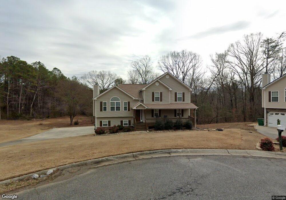
71 Hopkins Farm Dr Adairsville, GA 30103
Estimated Value: $307,000 - $353,000
4
Beds
3
Baths
1,930
Sq Ft
$168/Sq Ft
Est. Value
About This Home
This home is located at 71 Hopkins Farm Dr, Adairsville, GA 30103 and is currently estimated at $325,199, approximately $168 per square foot. 71 Hopkins Farm Dr is a home located in Bartow County with nearby schools including Adairsville Elementary School, Adairsville Middle School, and Adairsville High School.
Ownership History
Date
Name
Owned For
Owner Type
Purchase Details
Closed on
Jan 31, 2005
Sold by
Newberry Danny
Bought by
Griffin Michael J
Current Estimated Value
Home Financials for this Owner
Home Financials are based on the most recent Mortgage that was taken out on this home.
Original Mortgage
$118,320
Outstanding Balance
$60,022
Interest Rate
5.72%
Mortgage Type
New Conventional
Estimated Equity
$265,178
Create a Home Valuation Report for This Property
The Home Valuation Report is an in-depth analysis detailing your home's value as well as a comparison with similar homes in the area
Home Values in the Area
Average Home Value in this Area
Purchase History
| Date | Buyer | Sale Price | Title Company |
|---|---|---|---|
| Griffin Michael J | $147,900 | -- |
Source: Public Records
Mortgage History
| Date | Status | Borrower | Loan Amount |
|---|---|---|---|
| Open | Griffin Michael J | $118,320 | |
| Closed | Griffin Michael J | $29,580 |
Source: Public Records
Tax History Compared to Growth
Tax History
| Year | Tax Paid | Tax Assessment Tax Assessment Total Assessment is a certain percentage of the fair market value that is determined by local assessors to be the total taxable value of land and additions on the property. | Land | Improvement |
|---|---|---|---|---|
| 2024 | $2,846 | $133,320 | $22,600 | $110,720 |
| 2023 | $3,084 | $120,883 | $22,600 | $98,283 |
| 2022 | $2,397 | $100,976 | $14,000 | $86,976 |
| 2021 | $1,780 | $73,336 | $10,000 | $63,336 |
| 2020 | $1,877 | $73,336 | $10,000 | $63,336 |
| 2019 | $1,820 | $70,552 | $10,000 | $60,552 |
| 2018 | $1,565 | $61,160 | $10,000 | $51,160 |
| 2017 | $1,572 | $61,160 | $10,000 | $51,160 |
| 2016 | $1,584 | $61,160 | $10,000 | $51,160 |
| 2015 | $1,587 | $61,160 | $10,000 | $51,160 |
| 2014 | -- | $54,680 | $10,000 | $44,680 |
| 2013 | -- | $51,520 | $10,000 | $41,520 |
Source: Public Records
Map
Nearby Homes
- 69 Hopkins Farm Dr
- 50 Hopkins Farm Dr
- 31 Wesley Mill Dr
- 39 N Ridge Dr NW
- 356 W Oak Grove Rd NW
- 17 Chase Place
- 6633 Highway 140 NW
- 40 Wesley Rd NW
- 125 May St NW
- 0 Woody Rd NW Unit 10634615
- Lot 3 Snow Springs Rd
- 315 Woody Rd NW
- 0 Buttrum Rd NE Unit 10568159
- 0 Buttrum Rd NE Unit 7618816
- 2857 McDaniel Station Rd SW
- 73 Hopkins Farm Dr
- 72 Hopkins Farm Dr
- 70 Hopkins Farm Dr
- 68 Hopkins Farm Dr
- 12 Farmstead Ct
- 66 Hopkins Farm Dr
- 10 Farmstead Ct
- 64 Hopkins Farm Dr
- 13 Farmstead Ct
- 0 Hopkins Farms Dr
- 62 Hopkins Farm Dr
- 6428 Highway 140 NW
- 58 Hopkins Farm Dr
- 11 Farmstead Ct
- 56 Hopkins Farm Dr
- 54 Hopkins Farm Dr
- 47 Hopkins Farm Dr
- 52 Hopkins Farm Dr
- 22 Hopkins Breeze
- 20 Hopkins Breeze