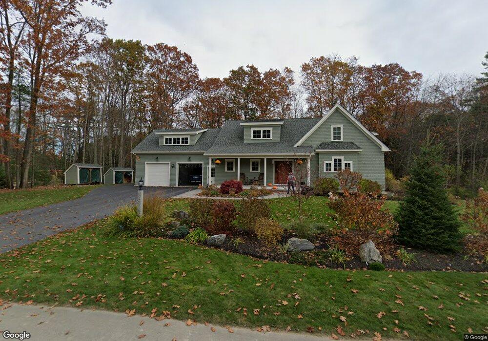
71 Pittee Creek Way Yarmouth, ME 04096
Estimated Value: $1,271,000 - $1,535,000
3
Beds
3
Baths
2,832
Sq Ft
$515/Sq Ft
Est. Value
About This Home
This home is located at 71 Pittee Creek Way, Yarmouth, ME 04096 and is currently estimated at $1,457,907, approximately $514 per square foot. 71 Pittee Creek Way is a home with nearby schools including William H. Rowe School, Yarmouth Elementary School, and Frank H. Harrison Middle School.
Ownership History
Date
Name
Owned For
Owner Type
Purchase Details
Closed on
May 24, 2011
Sold by
Stein Deborah
Bought by
Saldanha Gail and Allyn John
Current Estimated Value
Home Financials for this Owner
Home Financials are based on the most recent Mortgage that was taken out on this home.
Original Mortgage
$107,000
Outstanding Balance
$74,360
Interest Rate
4.88%
Mortgage Type
Purchase Money Mortgage
Estimated Equity
$1,383,547
Purchase Details
Closed on
Jan 18, 2006
Sold by
Cole Farm Barn Llc
Bought by
Stein Deborah
Create a Home Valuation Report for This Property
The Home Valuation Report is an in-depth analysis detailing your home's value as well as a comparison with similar homes in the area
Home Values in the Area
Average Home Value in this Area
Purchase History
| Date | Buyer | Sale Price | Title Company |
|---|---|---|---|
| Saldanha Gail | -- | -- | |
| Stein Deborah | -- | -- |
Source: Public Records
Mortgage History
| Date | Status | Borrower | Loan Amount |
|---|---|---|---|
| Open | Saldanha Gail | $107,000 |
Source: Public Records
Tax History Compared to Growth
Tax History
| Year | Tax Paid | Tax Assessment Tax Assessment Total Assessment is a certain percentage of the fair market value that is determined by local assessors to be the total taxable value of land and additions on the property. | Land | Improvement |
|---|---|---|---|---|
| 2024 | $19,283 | $751,200 | $241,700 | $509,500 |
| 2023 | $17,683 | $751,200 | $241,700 | $509,500 |
| 2022 | $16,241 | $751,200 | $241,700 | $509,500 |
| 2021 | $14,874 | $751,200 | $241,700 | $509,500 |
| 2020 | $14,724 | $751,200 | $241,700 | $509,500 |
| 2019 | $14,279 | $757,100 | $241,700 | $515,400 |
| 2018 | $13,476 | $757,100 | $241,700 | $515,400 |
| 2017 | $12,992 | $757,100 | $241,700 | $515,400 |
| 2016 | $12,916 | $757,100 | $241,700 | $515,400 |
| 2015 | $12,289 | $570,000 | $164,100 | $405,900 |
| 2014 | $12,312 | $570,000 | $164,100 | $405,900 |
| 2013 | $12,540 | $570,000 | $0 | $0 |
Source: Public Records
Map
Nearby Homes
- 51 Meeting House Farms Rd
- 24 York Ledge Dr
- 6 Daybreak Ln Unit 18
- 24 Daybreak Ln
- 1 Ledge Rd
- 86 Pleasant St
- 51 Pleasant St
- 52 Blueberry Cove Rd Unit 52
- 62 Blueberry Cove Rd Unit 62
- 20 Blueberry Cove Rd Unit 20
- 70 Main St
- 186 Foreside Rd
- 51 Oakland Ave
- 149 E Main St Unit 7
- 1 Railroad Square Unit Townhome C
- 1 Railroad Square Unit 103
- 1 Railroad Square Unit 205
- 1 Railroad Square Unit 305
- 1 Railroad Square Unit 403
- 1 Railroad Square Unit 101
- 7 Pittee Creek Way
- 70 Pittee Creek Way
- 5 Pittee Creek Way
- 79 Pittee Creek Way
- 45 Pittee Creek Way
- 82 Pittee Creek Way
- 34 Pittee Creek Way
- 8 Pittee Creek Dr
- 37 Pittee Creek Way
- 15 High Winds Dr
- 16 High Winds Dr
- 1 High Winds Dr
- 9 High Winds Dr
- 6 High Winds Dr
- 7 High Winds Dr
- 5 High Winds Dr
- 2 High Winds Dr
- 3 High Winds Dr
- 8 High Winds Dr
- 10 High Winds Dr