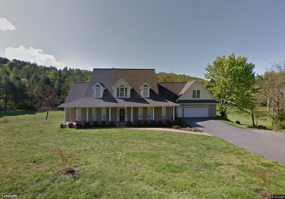
71 Upper Flat Creek Rd Weaverville, NC 28787
Estimated Value: $691,000 - $1,052,000
4
Beds
4
Baths
3,379
Sq Ft
$263/Sq Ft
Est. Value
About This Home
This home is located at 71 Upper Flat Creek Rd, Weaverville, NC 28787 and is currently estimated at $888,917, approximately $263 per square foot. 71 Upper Flat Creek Rd is a home located in Buncombe County with nearby schools including North Buncombe Elementary School, North Windy Ridge School, and North Buncombe Middle.
Ownership History
Date
Name
Owned For
Owner Type
Purchase Details
Closed on
Jun 17, 2024
Sold by
Powers Robert C and Powers Joan K
Bought by
Robert C Powers Living Trust
Current Estimated Value
Purchase Details
Closed on
Mar 30, 2007
Sold by
Shiver Sheri P
Bought by
Powers Robert C and Powers Joan K
Purchase Details
Closed on
Nov 30, 2006
Sold by
Ballard Helen Roberts Gill and Jordan Patricia G
Bought by
Shiver Sheri P
Create a Home Valuation Report for This Property
The Home Valuation Report is an in-depth analysis detailing your home's value as well as a comparison with similar homes in the area
Home Values in the Area
Average Home Value in this Area
Purchase History
| Date | Buyer | Sale Price | Title Company |
|---|---|---|---|
| Robert C Powers Living Trust | -- | None Listed On Document | |
| Robert C Powers Living Trust | -- | None Listed On Document | |
| Powers Robert C | $174,000 | None Available | |
| Shiver Sheri P | $272,000 | None Available |
Source: Public Records
Tax History Compared to Growth
Tax History
| Year | Tax Paid | Tax Assessment Tax Assessment Total Assessment is a certain percentage of the fair market value that is determined by local assessors to be the total taxable value of land and additions on the property. | Land | Improvement |
|---|---|---|---|---|
| 2025 | $4,124 | $644,100 | $23,000 | $621,100 |
| 2024 | $4,124 | $644,100 | $38,000 | $606,100 |
| 2023 | $4,124 | $644,100 | $38,000 | $606,100 |
| 2022 | $3,837 | $644,100 | $0 | $0 |
| 2021 | $3,837 | $644,100 | $0 | $0 |
| 2020 | $3,125 | $481,500 | $0 | $0 |
| 2019 | $3,125 | $481,500 | $0 | $0 |
| 2018 | $3,125 | $481,500 | $0 | $0 |
| 2017 | $3,135 | $386,300 | $0 | $0 |
| 2016 | $2,766 | $386,300 | $0 | $0 |
| 2015 | $2,766 | $386,300 | $0 | $0 |
| 2014 | $2,766 | $386,300 | $0 | $0 |
Source: Public Records
Map
Nearby Homes
- 8 Rose Briar Cir
- 219 Old Mars Hill Hwy
- 201 Murphy Hill Rd
- 3 Pleasant View Dr
- 209 Old Mars Hill Hwy
- 15 Gaddy Rd
- 40 Doan Rd
- 90 Kentwood Dr
- 109 Southwood Dr
- 198 Double Brook Dr
- 14 Red Maple Dr
- 42 Anna Glenn Ln
- 8 Maltese Ln
- 160 Mclean Rd
- 99999 Barnardsville Hwy Unit 121
- 99999 Barnardsville Hwy
- 1 Clarks Chapel Ridge Rd
- 114 Chapel Crossing Ln Unit 12
- 116 Chapel Crossing Ln Unit 11
- 115 Chapel Crossing Ln Unit 2
- 0 King Rd Unit 1-7 3416826
- 0 King Rd Unit NCM484649
- 000 King Rd
- 0 King Rd Unit NCM545044
- 0 King Rd Unit 3183424
- 0 King Rd Unit 1,2,3,4,5,6 3188296
- 0 King Rd Unit 1-7
- 0 King Rd Unit Tract 7 3668431
- 0 King Rd Unit 3668431
- 81 Upper Flat Creek Rd
- 2 King Rd
- 17 Powers Ridge Rd
- 11 Paw Nannys Way
- 78 Upper Flat Creek Rd
- 6 King Rd
- 10 Brank Cove Rd
- 20 King Rd
- 22 King Rd
- 24 Powers Ridge Rd
- 1 Brank Cove Rd