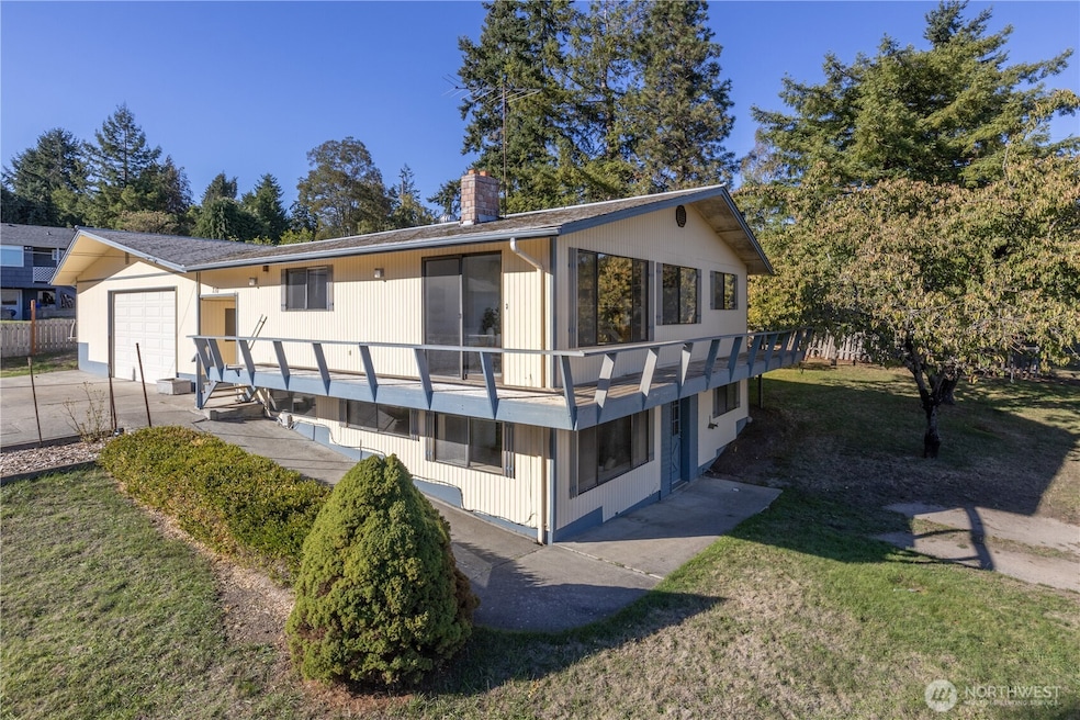
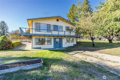
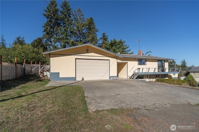
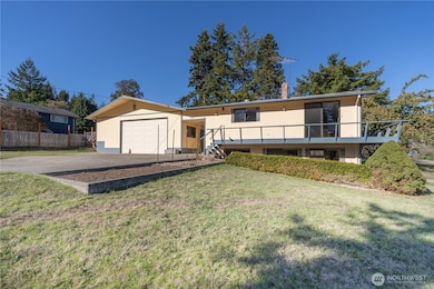
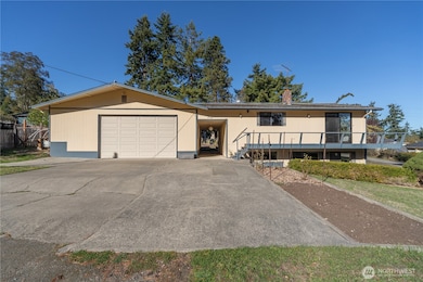
710 18th St Port Townsend, WA 98368
Estimated payment $3,226/month
Highlights
- Second Kitchen
- Fruit Trees
- Wood Burning Stove
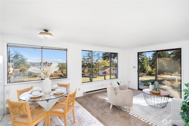
- Bay View
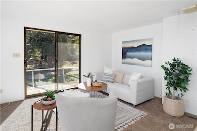
- Deck
- Property is near public transit
About This Home
This home offers a lovely territorial view of Kah Tai Lagoon & the courthouse, with stunning sunrises to enjoy from the living room. Set on a corner 10,000sqft lot with fruit trees & garden beds, there’s plenty of room to spread out. The 900 sqft double garage provides abundant project space. Inside, flexible living awaits: upstairs features a kitchen, living room, two bedrooms & a hall bath; downstairs offers a large family room, bedroom, 3⁄4 bath/laundry & a second kitchen. Previously a single-family home & also rented as two units, this centrally located property is ready for your vision.
Source: Northwest Multiple Listing Service (NWMLS)
MLS#: 2445063
Home Details
Home Type
- Single Family
Est. Annual Taxes
- $4,564
Year Built
- Built in 1978
Lot Details
- 9,583 Sq Ft Lot
- Lot Dimensions are 100x99
- Partially Fenced Property
- Corner Lot
- Sloped Lot
- Fruit Trees
- Garden
Parking
- 2 Car Attached Garage
Property Views
- Bay
- Pond
- City
- Mountain
- Territorial
Home Design
- Split Foyer
- Fixer Upper
- Slab Foundation
- Composition Roof
- Wood Siding
Interior Spaces
- 1,800 Sq Ft Home
- Multi-Level Property
- Wood Burning Stove
- Finished Basement
- Natural lighting in basement
- Storm Windows
Kitchen
- Second Kitchen
- Stove
Flooring
- Carpet
- Laminate
- Concrete
Bedrooms and Bathrooms
Laundry
- Dryer
- Washer
Outdoor Features
- Deck
Location
- Property is near public transit
- Property is near a bus stop
Schools
- Salish Coast Elementary School
- Blue Heron Mid Middle School
- Port Townsend High School
Utilities
- Baseboard Heating
- Water Heater
- High Speed Internet
Community Details
- No Home Owners Association
- Port Townsend Subdivision
Listing and Financial Details
- Down Payment Assistance Available
- Visit Down Payment Resource Website
- Legal Lot and Block 3&4 / 46
- Assessor Parcel Number 948304604
Map
Home Values in the Area
Average Home Value in this Area
Tax History
| Year | Tax Paid | Tax Assessment Tax Assessment Total Assessment is a certain percentage of the fair market value that is determined by local assessors to be the total taxable value of land and additions on the property. | Land | Improvement |
|---|---|---|---|---|
| 2024 | $4,440 | $523,059 | $194,250 | $328,809 |
| 2023 | $4,440 | $494,513 | $180,000 | $314,513 |
| 2022 | $3,244 | $484,513 | $170,000 | $314,513 |
| 2021 | $2,997 | $334,095 | $113,250 | $220,845 |
| 2020 | $2,824 | $297,659 | $99,660 | $197,999 |
| 2019 | $2,466 | $273,368 | $90,600 | $182,768 |
| 2018 | $2,710 | $259,392 | $90,600 | $168,792 |
| 2017 | $2,366 | $249,266 | $86,100 | $163,166 |
| 2016 | $2,055 | $232,386 | $86,100 | $146,286 |
| 2015 | $2,014 | $209,881 | $86,100 | $123,781 |
| 2014 | -- | $204,254 | $86,100 | $118,154 |
| 2013 | -- | $194,530 | $82,000 | $112,530 |
Property History
| Date | Event | Price | List to Sale | Price per Sq Ft |
|---|---|---|---|---|
| 10/20/2025 10/20/25 | Pending | -- | -- | -- |
| 10/15/2025 10/15/25 | For Sale | $540,000 | -- | $300 / Sq Ft |
Purchase History
| Date | Type | Sale Price | Title Company |
|---|---|---|---|
| Interfamily Deed Transfer | -- | None Available | |
| Personal Reps Deed | $280 | None Available | |
| Interfamily Deed Transfer | -- | None Available |
Source: Northwest Multiple Listing Service (NWMLS)
MLS Number: 2445063
APN: 948304604
Disclaimer: Certain information contained herein is derived from information provided by parties other than Homes.com. All information provided is deemed reliable, but is not guaranteed to be accurate and should be independently verified.
![]() All data is obtained from various sources and may not have been verified by broker or MLS GRID. Supplied Open House Information is subject to change without notice. All information should be independently reviewed and verified for accuracy. Properties may or may not be listed by the office/agent presenting the information. Listing information is provided by the Northwest Multiple Listing Service (NWMLS). Property information is based on available data that may include MLS information, county records, and other sources. Listings marked with the 3 tree icon and provided by NWMLS. All properties are subject to prior sale or withdrawal. IDX information is provided exclusively for consumers’ personal noncommercial use, that it may not be used for any purpose other than to identify prospective properties consumers may be interested in purchasing, that the data is deemed reliable but is not guaranteed by MLS GRID. ©2025 NWMLS.
All data is obtained from various sources and may not have been verified by broker or MLS GRID. Supplied Open House Information is subject to change without notice. All information should be independently reviewed and verified for accuracy. Properties may or may not be listed by the office/agent presenting the information. Listing information is provided by the Northwest Multiple Listing Service (NWMLS). Property information is based on available data that may include MLS information, county records, and other sources. Listings marked with the 3 tree icon and provided by NWMLS. All properties are subject to prior sale or withdrawal. IDX information is provided exclusively for consumers’ personal noncommercial use, that it may not be used for any purpose other than to identify prospective properties consumers may be interested in purchasing, that the data is deemed reliable but is not guaranteed by MLS GRID. ©2025 NWMLS.
Based on information submitted to the MLS GRID
- 1627 Holcomb St
- 412 19th St
- 1229 14th St
- 999 Jackman St
- 10 NKA Wilson St
- 1525 Grant St
- 0 Sherman St
- 480 State Route 20
- 2997 Hancock St
- 5679 Sheridan St
- 0 53XX Sheridan St
- 2012 Queen Anne Place
- 2055 Victoria Ave
- 2910 Kimball Ct Unit 2
- 2910 Kimball Ct Unit 1
- 2910 Kimball Ct Unit 10
- 2021 Clay St
- 1930 Lawrence St Unit A31
- 2257 W Rosecrans Ct
- 0 Lots 1-4 Hendricks St
