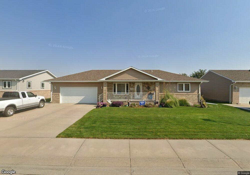
710 19th St Gering, NE 69341
Estimated Value: $252,000 - $347,000
2
Beds
3
Baths
1,120
Sq Ft
$263/Sq Ft
Est. Value
About This Home
This home is located at 710 19th St, Gering, NE 69341 and is currently estimated at $294,747, approximately $263 per square foot. 710 19th St is a home located in Scotts Bluff County with nearby schools including Gering High School and Community Christian Elementary/Middle School.
Ownership History
Date
Name
Owned For
Owner Type
Purchase Details
Closed on
Jul 26, 2016
Sold by
Asmus Rebecca L
Bought by
Burda Carol J and Carol J Burda Trust
Current Estimated Value
Purchase Details
Closed on
May 1, 2015
Sold by
Busskohl Rowland and Busskohl Kathy
Bought by
Asmus Rebecca L
Home Financials for this Owner
Home Financials are based on the most recent Mortgage that was taken out on this home.
Original Mortgage
$160,000
Interest Rate
3.84%
Mortgage Type
New Conventional
Purchase Details
Closed on
Feb 15, 2013
Sold by
Busskohl Rowland and Busskohl Kathy
Bought by
Busskohl Rowland and Busskohl Kathy
Create a Home Valuation Report for This Property
The Home Valuation Report is an in-depth analysis detailing your home's value as well as a comparison with similar homes in the area
Home Values in the Area
Average Home Value in this Area
Purchase History
| Date | Buyer | Sale Price | Title Company |
|---|---|---|---|
| Burda Carol J | $215,000 | Western Prairie Title | |
| Asmus Rebecca L | $200,000 | None Available | |
| Busskohl Rowland | -- | None Available |
Source: Public Records
Mortgage History
| Date | Status | Borrower | Loan Amount |
|---|---|---|---|
| Previous Owner | Asmus Rebecca L | $160,000 |
Source: Public Records
Tax History
| Year | Tax Paid | Tax Assessment Tax Assessment Total Assessment is a certain percentage of the fair market value that is determined by local assessors to be the total taxable value of land and additions on the property. | Land | Improvement |
|---|---|---|---|---|
| 2025 | $4,628 | $275,075 | $24,300 | $250,775 |
| 2024 | $4,489 | $260,880 | $24,300 | $236,580 |
| 2023 | $4,687 | $218,704 | $18,972 | $199,732 |
| 2022 | $4,687 | $218,704 | $18,972 | $199,732 |
| 2021 | $4,456 | $205,637 | $18,972 | $186,665 |
| 2020 | $4,288 | $196,748 | $18,972 | $177,776 |
| 2019 | $4,184 | $196,748 | $18,972 | $177,776 |
| 2018 | $4,209 | $196,748 | $18,972 | $177,776 |
| 2017 | $4,069 | $189,910 | $18,972 | $170,938 |
| 2016 | $3,777 | $189,910 | $18,972 | $170,938 |
| 2015 | $3,666 | $184,931 | $18,972 | $165,959 |
| 2014 | $3,718 | $184,931 | $18,972 | $165,959 |
| 2012 | -- | $181,677 | $18,972 | $162,705 |
Source: Public Records
Map
Nearby Homes
Your Personal Tour Guide
Ask me questions while you tour the home.