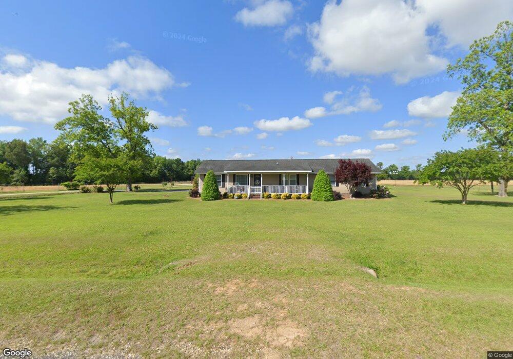
710 1st Oxtown Rd Scranton, SC 29591
Estimated Value: $120,000 - $200,508
2
Beds
2
Baths
1,848
Sq Ft
$89/Sq Ft
Est. Value
About This Home
This home is located at 710 1st Oxtown Rd, Scranton, SC 29591 and is currently estimated at $164,627, approximately $89 per square foot. 710 1st Oxtown Rd is a home located in Florence County with nearby schools including Ronald E. McNair Junior High School and Lake City High School.
Ownership History
Date
Name
Owned For
Owner Type
Purchase Details
Closed on
Apr 29, 2014
Sold by
Hayes Robert Kevin
Bought by
Hayes Robert Kevin and Welch Janice F
Current Estimated Value
Home Financials for this Owner
Home Financials are based on the most recent Mortgage that was taken out on this home.
Original Mortgage
$161,503
Interest Rate
4.37%
Mortgage Type
New Conventional
Purchase Details
Closed on
Aug 20, 2013
Sold by
Hayes Christina H
Bought by
Hayes Robert Kevin
Home Financials for this Owner
Home Financials are based on the most recent Mortgage that was taken out on this home.
Original Mortgage
$105,890
Interest Rate
4.48%
Mortgage Type
New Conventional
Purchase Details
Closed on
Sep 20, 2004
Sold by
Hayes Robert Kevin
Bought by
Hayes Robert Kevin and Hayes Christina H
Create a Home Valuation Report for This Property
The Home Valuation Report is an in-depth analysis detailing your home's value as well as a comparison with similar homes in the area
Home Values in the Area
Average Home Value in this Area
Purchase History
| Date | Buyer | Sale Price | Title Company |
|---|---|---|---|
| Hayes Robert Kevin | -- | -- | |
| Hayes Robert Kevin | -- | -- | |
| Hayes Robert Kevin | -- | -- |
Source: Public Records
Mortgage History
| Date | Status | Borrower | Loan Amount |
|---|---|---|---|
| Closed | Hayes Robert Kevin | $161,503 | |
| Closed | Hayes Robert Kevin | $105,890 |
Source: Public Records
Tax History Compared to Growth
Tax History
| Year | Tax Paid | Tax Assessment Tax Assessment Total Assessment is a certain percentage of the fair market value that is determined by local assessors to be the total taxable value of land and additions on the property. | Land | Improvement |
|---|---|---|---|---|
| 2024 | $434 | $4,801 | $1,142 | $3,659 |
| 2023 | $409 | $3,658 | $1,142 | $2,516 |
| 2022 | $550 | $3,658 | $1,142 | $2,516 |
| 2021 | $423 | $3,750 | $0 | $0 |
| 2020 | $559 | $3,750 | $0 | $0 |
| 2019 | $562 | $3,658 | $1,142 | $2,516 |
| 2018 | $502 | $3,750 | $0 | $0 |
| 2017 | $518 | $3,750 | $0 | $0 |
| 2016 | $434 | $3,750 | $0 | $0 |
| 2015 | $431 | $3,750 | $0 | $0 |
| 2014 | $361 | $3,280 | $1,142 | $2,138 |
Source: Public Records
Map
Nearby Homes
- 234 Oak St
- 1677 Cockfield Rd Unit LOT 11
- 1677 Cockfield Rd Unit LOT 10
- 1677 Cockfield Rd Unit LOT 9
- 1677 Cockfield Rd Unit LOT 8
- 139 Emily Rd
- 615 E Main St
- 520 E Main St
- 114 Lake St
- 115 Carolina Ave
- 120 Rodgers Ave
- 1929 Boyd St
- 506 Taylor St
- 13 Robert Rd
- 14 Robert Rd
- 15 Dansing St
- Martha Law #3 Lot 37
- TBD Robert Rd
- 430 Alane St
- 124 Singletary Ave
- 663 1st Oxtown Rd
- 732 1st Oxtown Rd
- 719 Hanna Rd
- 740 1st Oxtown Rd
- 740 Hanna Rd
- 730 Hanna Rd
- 746 Hanna Rd
- 948 Dublin Rd
- 714 Hanna Rd
- 764 1st Oxtown Rd
- 625 Hanna Rd
- 776 Carvin Rd
- 1058 Miles Rd
- 555 1st Oxtown Rd
- 942 Daylily Ln
- 531 Hanna Rd
- 1104 Donald Rd
- 836 1st Oxtown Rd
- 1042 Beaumont Rd
- 1143 Casselman Rd