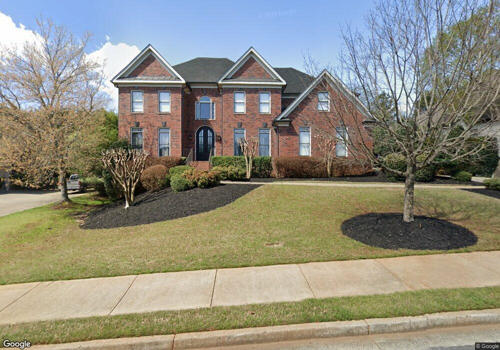
710 Cottonfield Trace Alpharetta, GA 30022
Estimated Value: $1,151,740 - $1,264,000
6
Beds
5
Baths
3,749
Sq Ft
$321/Sq Ft
Est. Value
About This Home
This home is located at 710 Cottonfield Trace, Alpharetta, GA 30022 and is currently estimated at $1,202,185, approximately $320 per square foot. 710 Cottonfield Trace is a home located in Fulton County with nearby schools including New Prospect Elementary School, Webb Bridge Middle School, and Alpharetta High School.
Ownership History
Date
Name
Owned For
Owner Type
Purchase Details
Closed on
Aug 12, 2009
Sold by
Leach Willard M and Leach Maureen L
Bought by
Glencross Christopher J and Glencross Kara S
Current Estimated Value
Home Financials for this Owner
Home Financials are based on the most recent Mortgage that was taken out on this home.
Original Mortgage
$375,000
Outstanding Balance
$245,125
Interest Rate
5.26%
Mortgage Type
New Conventional
Estimated Equity
$957,060
Purchase Details
Closed on
Oct 9, 1998
Sold by
Blue Pond Homes Inc
Bought by
Leach Willard M and Leach Maureen L
Home Financials for this Owner
Home Financials are based on the most recent Mortgage that was taken out on this home.
Original Mortgage
$280,000
Interest Rate
6.8%
Mortgage Type
New Conventional
Create a Home Valuation Report for This Property
The Home Valuation Report is an in-depth analysis detailing your home's value as well as a comparison with similar homes in the area
Home Values in the Area
Average Home Value in this Area
Purchase History
| Date | Buyer | Sale Price | Title Company |
|---|---|---|---|
| Glencross Christopher J | $560,000 | -- | |
| Leach Willard M | $375,000 | -- |
Source: Public Records
Mortgage History
| Date | Status | Borrower | Loan Amount |
|---|---|---|---|
| Open | Glencross Christopher J | $375,000 | |
| Previous Owner | Leach Willard M | $280,000 |
Source: Public Records
Tax History Compared to Growth
Tax History
| Year | Tax Paid | Tax Assessment Tax Assessment Total Assessment is a certain percentage of the fair market value that is determined by local assessors to be the total taxable value of land and additions on the property. | Land | Improvement |
|---|---|---|---|---|
| 2025 | $1,978 | $474,000 | $107,880 | $366,120 |
| 2023 | $10,558 | $374,040 | $70,760 | $303,280 |
| 2022 | $8,081 | $307,160 | $60,160 | $247,000 |
| 2021 | $8,642 | $262,840 | $50,320 | $212,520 |
| 2020 | $8,768 | $261,400 | $54,920 | $206,480 |
| 2019 | $1,420 | $246,880 | $51,760 | $195,120 |
| 2018 | $7,626 | $270,160 | $53,800 | $216,360 |
| 2017 | $7,589 | $260,120 | $49,080 | $211,040 |
| 2016 | $7,591 | $260,120 | $49,080 | $211,040 |
| 2015 | $9,118 | $260,120 | $49,080 | $211,040 |
| 2014 | $6,462 | $210,800 | $42,360 | $168,440 |
Source: Public Records
Map
Nearby Homes
- 420 Seale Trail
- 1050 Ambrose Ave Unit 1
- 122 Pinecone Pkwy
- 2718 Wander Ln
- 202 Pinecone Place
- 204 Pinecone Place
- 0 N Point Pkwy Unit 10605589
- 0 N Point Pkwy Unit 7649723
- 725 High Hampton Run
- 10900 Wittenridge Dr Unit I3
- 10900 Wittenridge Dr Unit H8
- 10900 Wittenridge Dr Unit L6
- 10625 Haynes Forest Dr
- 3335 Waters Mill Dr
- 11255 Wittenridge Dr
- 870 Thornberry Dr Unit 2
- 3430 Waters Mill Dr
- 355 Fairleaf Ct
- 225 Wentworth Terrace
- 0 Seale Dr Unit 7406682
- 0 Seale Dr Unit 8673122
- 0 Seale Dr Unit 8457540
- 0 Seale Dr Unit 8395453
- 0 Seale Dr Unit 8334888
- 0 Seale Dr Unit 8041603
- 0 Seale Dr Unit 8004287
- 0 Seale Dr Unit 8684069
- 0 Seale Dr Unit 8047387
- 0 Seale Dr Unit 8009654
- 0 Seale Dr Unit 8985038
- 0 Seale Dr Unit 8743078
- 0 Seale Dr Unit 8793060
- 0 Seale Dr Unit 3260037
- 0 Seale Dr Unit 7279029
- 0 Seale Dr Unit 7295637
- 0 Seale Dr Unit 7388487
- 0 Seale Dr Unit 7503907
- 0 Seale Dr Unit 7535424
- 0 Seale Dr Unit 7587627