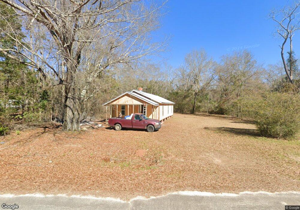
710 Ga Highway 39 S Georgetown, GA 39854
Estimated Value: $36,108 - $129,000
2
Beds
1
Bath
1,152
Sq Ft
$75/Sq Ft
Est. Value
About This Home
This home is located at 710 Ga Highway 39 S, Georgetown, GA 39854 and is currently estimated at $86,777, approximately $75 per square foot. 710 Ga Highway 39 S is a home located in Quitman County with nearby schools including Quitman County Elementary School and Quitman County High School.
Ownership History
Date
Name
Owned For
Owner Type
Purchase Details
Closed on
Jul 10, 2020
Sold by
Parkman Charlie M
Bought by
Rushing Carol Mixon and Mixon Leonard
Current Estimated Value
Purchase Details
Closed on
Feb 4, 2003
Sold by
Mixon Lula M
Bought by
Parkman Charlie M
Purchase Details
Closed on
Aug 8, 2002
Sold by
Waugh Eskew and Waugh Mixon
Bought by
Mixon Lula M
Purchase Details
Closed on
Aug 29, 1978
Sold by
Bussey Izetta
Bought by
Waugh Eskew and Waugh Mixon
Purchase Details
Closed on
Jan 4, 1978
Sold by
Bussey Leonard
Bought by
Bussey Izetta
Purchase Details
Closed on
Dec 19, 1977
Bought by
Bussey Leonard
Create a Home Valuation Report for This Property
The Home Valuation Report is an in-depth analysis detailing your home's value as well as a comparison with similar homes in the area
Home Values in the Area
Average Home Value in this Area
Purchase History
| Date | Buyer | Sale Price | Title Company |
|---|---|---|---|
| Rushing Carol Mixon | $13,000 | -- | |
| Parkman Charlie M | $6,000 | -- | |
| Mixon Lula M | -- | -- | |
| Waugh Eskew | -- | -- | |
| Bussey Izetta | -- | -- | |
| Bussey Leonard | -- | -- |
Source: Public Records
Tax History Compared to Growth
Tax History
| Year | Tax Paid | Tax Assessment Tax Assessment Total Assessment is a certain percentage of the fair market value that is determined by local assessors to be the total taxable value of land and additions on the property. | Land | Improvement |
|---|---|---|---|---|
| 2025 | $379 | $7,678 | $3,240 | $4,438 |
| 2024 | $379 | $4,640 | $3,240 | $1,400 |
| 2023 | $381 | $4,640 | $3,240 | $1,400 |
| 2022 | $381 | $4,640 | $3,240 | $1,400 |
| 2021 | $238 | $5,283 | $4,883 | $400 |
| 2020 | $295 | $6,990 | $4,883 | $2,107 |
| 2019 | $295 | $6,990 | $4,883 | $2,107 |
| 2018 | $224 | $6,990 | $4,883 | $2,107 |
| 2017 | $224 | $7,313 | $4,883 | $2,430 |
| 2016 | $234 | $7,314 | $4,883 | $2,430 |
| 2015 | -- | $7,314 | $4,883 | $2,430 |
| 2014 | -- | $7,314 | $4,883 | $2,430 |
| 2013 | -- | $7,313 | $4,883 | $2,430 |
Source: Public Records
Map
Nearby Homes
- 98 Cool Branch Rd
- 000 Cool Branch Rd
- 0 Cool Branch Rd
- 1 Cool Branch Rd
- 48 Ralph Sr Rd
- 24 Point Dr
- 47 Plantation Blvd
- 43 Plantation Blvd
- 00 Plantation Blvd
- 327 Deer Point Rd
- 327 Deer Point Rd Unit 492 +/- ACRES
- 102-103 Magnolia Dr
- 10 Whip o Will Ln
- 191 Lewis Moore Rd
- 15 Bay Ln
- 124 Woodland Dr
- 128 Woodland Dr
- 126 Woodland Dr
- 119 Woodland Dr
- 111 Arrowhead Dr
- 26 Parkman Rd
- 704 Ga Highway 39 S
- 1 Griggs Ln
- 696 Ga Highway 39 S
- 709 Ga Highway 39 S
- 703 Ga Highway 39 S
- 3 Pine Loop
- 28 Pine Loop
- 37 Cool Branch Rd
- 52A Cool Branch Rd
- 628 Georgia 39
- 610 Ga Highway 39 S
- 610 Georgia 39
- 609 Ga Highway 39 S
- 73 Cool Branch Rd
- 81 Cool Branch Rd
- 140 Cool Branch Rd
- 4 Byrd Rd
- 7 Deer Point Rd
- 17 Deer Point Rd Unit 17