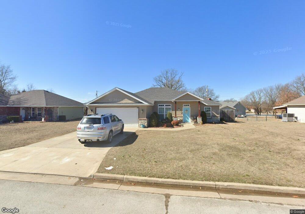
710 Hayes Ave Carl Junction, MO 64834
Estimated Value: $231,999 - $245,000
3
Beds
2
Baths
1,503
Sq Ft
$160/Sq Ft
Est. Value
About This Home
This home is located at 710 Hayes Ave, Carl Junction, MO 64834 and is currently estimated at $240,750, approximately $160 per square foot. 710 Hayes Ave is a home located in Jasper County with nearby schools including Carl Junction Primary School (K-1), Carl Junction Intermediate School, and Carl Junction Primary School (2-3).
Ownership History
Date
Name
Owned For
Owner Type
Purchase Details
Closed on
Jul 1, 2019
Sold by
Hansen Jeffrey and Hansen Sarah
Bought by
Wehner David A and Wehner Jessica K
Current Estimated Value
Home Financials for this Owner
Home Financials are based on the most recent Mortgage that was taken out on this home.
Original Mortgage
$142,025
Outstanding Balance
$124,100
Interest Rate
3.9%
Mortgage Type
New Conventional
Estimated Equity
$116,650
Create a Home Valuation Report for This Property
The Home Valuation Report is an in-depth analysis detailing your home's value as well as a comparison with similar homes in the area
Purchase History
| Date | Buyer | Sale Price | Title Company |
|---|---|---|---|
| Wehner David A | -- | -- |
Source: Public Records
Mortgage History
| Date | Status | Borrower | Loan Amount |
|---|---|---|---|
| Open | Wehner David A | $142,025 |
Source: Public Records
Tax History
| Year | Tax Paid | Tax Assessment Tax Assessment Total Assessment is a certain percentage of the fair market value that is determined by local assessors to be the total taxable value of land and additions on the property. | Land | Improvement |
|---|---|---|---|---|
| 2025 | $1,373 | $26,030 | $2,150 | $23,880 |
| 2024 | $1,381 | $23,460 | $2,150 | $21,310 |
| 2023 | $1,381 | $23,460 | $2,150 | $21,310 |
| 2022 | $1,409 | $23,870 | $2,150 | $21,720 |
| 2021 | $1,209 | $23,870 | $2,150 | $21,720 |
| 2020 | $1,130 | $21,930 | $2,150 | $19,780 |
| 2019 | $1,073 | $21,930 | $2,150 | $19,780 |
| 2018 | $1,080 | $22,130 | $0 | $0 |
| 2017 | $1,083 | $22,130 | $0 | $0 |
| 2016 | $104 | $2,150 | $0 | $0 |
| 2015 | -- | $2,150 | $0 | $0 |
| 2014 | -- | $2,150 | $0 | $0 |
Source: Public Records
Map
Nearby Homes
- 410 Walton St
- 501 W Walton Ave
- 409 W Walton Ave
- 406 W Walton Ave
- 509 W Gault St
- 501 S Cowgill St
- 503 S Main St
- 817 Delaney Dr
- Tract 3 Prairie Ln
- Tract 2 Prairie Ln
- Tract 1 Prairie Ln
- Tract 4 Prairie Ln
- 711 Prairie Ln
- 608 Valley View St
- 809 Aberdeen Ave
- 901 Aberdeen Ave
- 505 N Broadway Ave
- 604 Pennell St
- TBD Temple St
- 720 Sheridan Ave
- 712 Hayes Ave
- 708 Hayes Ave
- 510 Marshall
- 509 Marshall Ave
- 704 Hayes Ave
- 508 Marshall
- 802 Hayes Ave
- 507 Marshall
- 702 Hayes Ave
- 506 Marshall
- 512 Walton St
- 512 Walton St Unit 1
- 512 W Walton Ave
- 505 Marshall Ave
- 510 W Walton Ave
- 504 Marshall
- Lot 42 Hayes Ave
- 503 Marshall Ave
- 508 Walton St
- 508 W Walton Ave
Your Personal Tour Guide
Ask me questions while you tour the home.