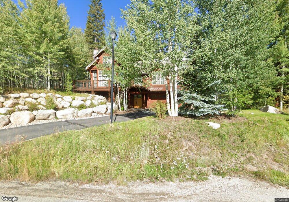
710 Willowbrook Rd Silverthorne, CO 80498
Estimated Value: $2,046,605 - $2,396,000
4
Beds
6
Baths
2,718
Sq Ft
$806/Sq Ft
Est. Value
About This Home
This home is located at 710 Willowbrook Rd, Silverthorne, CO 80498 and is currently estimated at $2,190,901, approximately $806 per square foot. 710 Willowbrook Rd is a home with nearby schools including Silverthorne Elementary School, Summit Middle School, and Summit High School.
Ownership History
Date
Name
Owned For
Owner Type
Purchase Details
Closed on
Apr 21, 2009
Sold by
Silianoff A Raven and Silianoff Gordon
Bought by
Limbird Keith and Limbird Julia
Current Estimated Value
Home Financials for this Owner
Home Financials are based on the most recent Mortgage that was taken out on this home.
Original Mortgage
$625,500
Outstanding Balance
$399,644
Interest Rate
5.14%
Mortgage Type
New Conventional
Estimated Equity
$1,791,257
Purchase Details
Closed on
Jul 23, 2007
Sold by
The Kunz Family Revocable Trust
Bought by
Silianoff A Raven and Silianoff Gordon
Create a Home Valuation Report for This Property
The Home Valuation Report is an in-depth analysis detailing your home's value as well as a comparison with similar homes in the area
Home Values in the Area
Average Home Value in this Area
Purchase History
| Date | Buyer | Sale Price | Title Company |
|---|---|---|---|
| Limbird Keith | $985,000 | Stewart Title | |
| Silianoff A Raven | $242,500 | Land Title Guarantee Company |
Source: Public Records
Mortgage History
| Date | Status | Borrower | Loan Amount |
|---|---|---|---|
| Open | Limbird Keith | $625,500 |
Source: Public Records
Tax History
| Year | Tax Paid | Tax Assessment Tax Assessment Total Assessment is a certain percentage of the fair market value that is determined by local assessors to be the total taxable value of land and additions on the property. | Land | Improvement |
|---|---|---|---|---|
| 2024 | $7,054 | $134,262 | -- | -- |
| 2023 | $7,054 | $130,576 | $0 | $0 |
| 2022 | $4,745 | $83,039 | $0 | $0 |
| 2021 | $4,786 | $85,428 | $0 | $0 |
| 2020 | $4,269 | $81,409 | $0 | $0 |
| 2019 | $4,211 | $81,409 | $0 | $0 |
| 2018 | $3,989 | $74,727 | $0 | $0 |
| 2017 | $3,648 | $74,727 | $0 | $0 |
| 2016 | $3,356 | $67,707 | $0 | $0 |
| 2015 | $3,251 | $67,707 | $0 | $0 |
| 2014 | $3,392 | $69,742 | $0 | $0 |
| 2013 | -- | $69,742 | $0 | $0 |
Source: Public Records
Map
Nearby Homes
- 1803 Falcon Dr
- 481 Marmot Cir
- 490 W Coyote Dr
- 273 Two Cabins Dr
- 480 W Coyote Dr
- 308 Red Hawk Cir
- 125 Two Cabins Dr
- 1709 Red Hawk Rd
- 432 Bighorn Cir
- 383 W Coyote Dr
- 1730 Red Hawk Rd
- 345 N Chipmunk Cir
- 210 Easy Bend Trail
- 170 Middle Park Ct
- 89 Emerald Rd
- 1325 Golden Eagle Rd
- 195 Easy Bend Trail
- 324 Black Hawk Cir
- 209 E Fox Ct
- 190 Easy Bend Trail
- 712 Willowbrook Rd
- 716 Willowbrook Rd
- 706 Willowbrook Rd
- 709 Willowbrook Rd
- 707 Willowbrook Rd
- 711 Willowbrook Rd
- 704 Willowbrook Rd
- 705 Willowbrook Rd
- 106 Willow Creek Ridge Cir
- 720 Willowbrook Rd
- 104 Willow Creek Ridge Cir
- 703 Willowbrook Rd
- 108 Willow Creek Ridge Cir
- 718 Willowbrook Rd
- 764 Willow Creek Ct
- 701 Willowbrook Rd
- 715 Willowbrook Rd
- 110 Willow Creek Ridge Cir
- 766 Willow Creek Ct
- 112 Willow Creek Ridge Cir
Your Personal Tour Guide
Ask me questions while you tour the home.