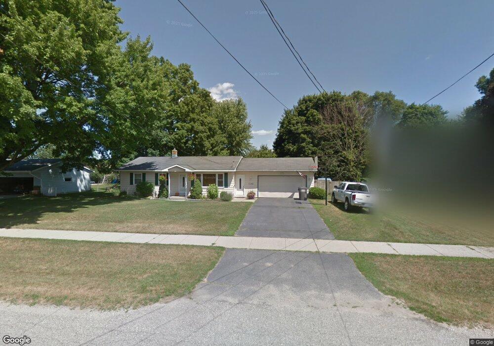
7104 23rd Ave Jenison, MI 49428
Estimated Value: $334,000 - $356,000
3
Beds
2
Baths
1
Sq Ft
$346,557/Sq Ft
Est. Value
About This Home
This home is located at 7104 23rd Ave, Jenison, MI 49428 and is currently estimated at $346,557, approximately $346,557 per square foot. 7104 23rd Ave is a home located in Ottawa County with nearby schools including Rosewood Elementary School, Jenison Junior High School, and Jenison High School.
Ownership History
Date
Name
Owned For
Owner Type
Purchase Details
Closed on
Mar 1, 2021
Sold by
Emaus Patricia
Bought by
Emaus Patricia and Emaus Ryan
Current Estimated Value
Purchase Details
Closed on
Jan 9, 2020
Sold by
Emaus Patricia L
Bought by
Emaus Patricia L and Emaus Ryan
Home Financials for this Owner
Home Financials are based on the most recent Mortgage that was taken out on this home.
Original Mortgage
$130,000
Interest Rate
3.2%
Mortgage Type
New Conventional
Create a Home Valuation Report for This Property
The Home Valuation Report is an in-depth analysis detailing your home's value as well as a comparison with similar homes in the area
Home Values in the Area
Average Home Value in this Area
Purchase History
| Date | Buyer | Sale Price | Title Company |
|---|---|---|---|
| Emaus Patricia | -- | Ata National Title Group Llc | |
| Emaus Patricia | -- | None Available | |
| Emaus Patricia L | -- | Avenue 365 Lender Svcs Llc |
Source: Public Records
Mortgage History
| Date | Status | Borrower | Loan Amount |
|---|---|---|---|
| Closed | Emaus Patricia L | $130,000 |
Source: Public Records
Tax History
| Year | Tax Paid | Tax Assessment Tax Assessment Total Assessment is a certain percentage of the fair market value that is determined by local assessors to be the total taxable value of land and additions on the property. | Land | Improvement |
|---|---|---|---|---|
| 2025 | $2,427 | $164,900 | $0 | $0 |
| 2024 | $23 | $141,200 | $0 | $0 |
| 2023 | $2,227 | $131,000 | $0 | $0 |
| 2022 | $2,445 | $112,500 | $0 | $0 |
| 2021 | $2,374 | $100,300 | $0 | $0 |
| 2020 | $1,880 | $98,900 | $0 | $0 |
| 2019 | $1,882 | $91,700 | $0 | $0 |
| 2018 | $1,755 | $86,200 | $0 | $0 |
| 2017 | $1,724 | $83,400 | $0 | $0 |
| 2016 | $1,714 | $75,800 | $0 | $0 |
| 2015 | $1,636 | $71,000 | $0 | $0 |
| 2014 | $1,636 | $67,800 | $0 | $0 |
Source: Public Records
Map
Nearby Homes
- 7458 Coconut Dr
- 7425 Pinegrove Dr Unit 98
- 7341 Pinegrove Dr
- 2272 Baldwin St
- 7373 Pinegrove Dr Unit 109
- 2921 Rosewood St
- 6724 28th Ave
- 2881 N Wentward Ct Unit 43
- 7439 Eastlane Ave
- 9067 Hollace Ct
- 7728 Hollyhock Ave
- 6704 Sheldon Crossings Dr Unit 45
- 6706 Sheldon Crossings Dr Unit 46
- 6645 Croft Ln Unit 30
- 6340 Summer Dr
- 7425 Boulder Bluff Dr Unit 112
- 6352 Livingston Ct
- 7521 Boulder Bluff Dr Unit 81
- 1941 Newcastle Dr
- 2934 Parkside Dr Unit 54
- 7092 23rd Ave
- 7118 23rd Ave
- 7109 Olde Farm Dr
- 7095 Olde Farm Dr
- 7117 Olde Farm Dr
- 7087 Olde Farm Dr
- 7076 23rd Ave
- 7134 23rd Ave
- 7125 Olde Farm Dr
- 7111 23rd Ave
- 7101 23rd Ave
- 7079 Olde Farm Dr
- 7125 23rd Ave
- 7085 23rd Ave
- 7139 Olde Farm Dr
- 7065 Olde Farm Dr
- 7150 23rd Ave
- 7060 23rd Ave
- 2227 Oak Hollow Dr
- 2228 Sandstone Dr
Your Personal Tour Guide
Ask me questions while you tour the home.