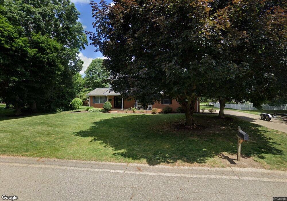
7109 Barnstable Cir NW Canton, OH 44718
Lake Cable NeighborhoodEstimated Value: $367,000 - $460,000
3
Beds
3
Baths
2,155
Sq Ft
$185/Sq Ft
Est. Value
About This Home
This home is located at 7109 Barnstable Cir NW, Canton, OH 44718 and is currently estimated at $398,069, approximately $184 per square foot. 7109 Barnstable Cir NW is a home located in Stark County with nearby schools including Sauder Elementary School, Jackson Memorial Middle School, and Jackson High School.
Ownership History
Date
Name
Owned For
Owner Type
Purchase Details
Closed on
Feb 9, 2023
Sold by
Rinaldi Sherry R
Bought by
Sherry R Rinaldi Revocable Living Trust and Rinaldi
Current Estimated Value
Purchase Details
Closed on
Oct 14, 2008
Sold by
Rinaldi Louis and Rinaldi Sherry R
Bought by
Rinaldi Louis and Rinaldi Sherry R
Create a Home Valuation Report for This Property
The Home Valuation Report is an in-depth analysis detailing your home's value as well as a comparison with similar homes in the area
Home Values in the Area
Average Home Value in this Area
Purchase History
| Date | Buyer | Sale Price | Title Company |
|---|---|---|---|
| Sherry R Rinaldi Revocable Living Trust | -- | None Listed On Document | |
| Rinaldi Louis | -- | Attorney |
Source: Public Records
Tax History Compared to Growth
Tax History
| Year | Tax Paid | Tax Assessment Tax Assessment Total Assessment is a certain percentage of the fair market value that is determined by local assessors to be the total taxable value of land and additions on the property. | Land | Improvement |
|---|---|---|---|---|
| 2025 | -- | $116,980 | $37,560 | $79,420 |
| 2024 | -- | $116,980 | $37,560 | $79,420 |
| 2023 | $3,932 | $78,370 | $28,600 | $49,770 |
| 2022 | $3,914 | $78,370 | $28,600 | $49,770 |
| 2021 | $3,929 | $78,370 | $28,600 | $49,770 |
| 2020 | $3,719 | $68,150 | $24,680 | $43,470 |
| 2019 | $3,583 | $69,760 | $24,680 | $45,080 |
| 2018 | $3,685 | $69,760 | $24,680 | $45,080 |
| 2017 | $3,676 | $66,220 | $22,540 | $43,680 |
| 2016 | $3,568 | $63,810 | $22,540 | $41,270 |
| 2015 | $3,611 | $63,810 | $22,540 | $41,270 |
| 2014 | $1,476 | $58,740 | $20,760 | $37,980 |
| 2013 | $1,711 | $58,740 | $20,760 | $37,980 |
Source: Public Records
Map
Nearby Homes
- 5507 Foxboro Ave NW
- 5820 Kildare Cir NW
- 5691 Governors Ave NW
- 5017 Nobles Pond Dr NW
- 6311 Sorrento Ave NW
- 6104 Shipslanding Ave NW
- 4883 Earlscourt Cir NW
- 7034 Celina St NW
- 6257 Island Dr NW
- 6424 Pebble Beach Dr NW
- 6422 Pebble Beach Dr NW
- 6394 Bayside St NW
- 6451 Shenandoah Ave NW
- 4826 Nobles Pond Dr NW
- 6263 Doral Dr NW
- 5433 Fleetwood Ave NW
- 0 Stoneywood Cir NW Unit 5051952
- 6422 Stoneywood Cir NW
- 0 Armandale Ave NW Unit 5052422
- 0 Armandale Ave NW Unit 5052421
- 5640 Foxboro Ave NW
- 7083 Barnstable Cir NW
- 7136 Andiron Cir NW
- 7100 Barnstable Cir NW
- 7092 Barnstable Cir NW
- 5606 Foxboro Ave NW
- 7098 Andiron Cir NW
- 7156 Andiron Cir NW
- 7084 Barnstable Cir NW
- 5584 Foxboro Ave NW
- 7053 Militia Hill St NW
- 7097 Andiron Cir NW
- 7057 Militia Hill St NW
- 5637 Foxboro Ave NW
- 5617 Foxboro Ave NW
- 7047 Militia Hill St NW
- 7105 Andiron Cir NW
- 7131 Andiron Cir NW
- 7074 Barnstable Cir NW
- 5667 Foxboro Ave NW