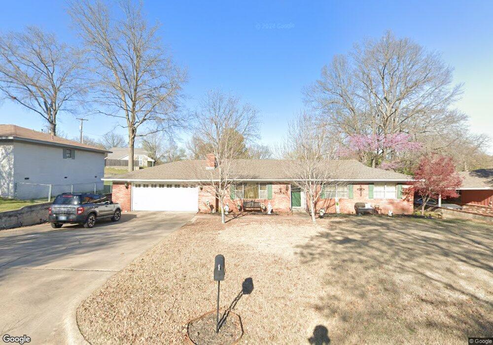
711 Brentwood Dr Tahlequah, OK 74464
Estimated Value: $174,065 - $224,000
3
Beds
2
Baths
1,601
Sq Ft
$128/Sq Ft
Est. Value
About This Home
This home is located at 711 Brentwood Dr, Tahlequah, OK 74464 and is currently estimated at $205,266, approximately $128 per square foot. 711 Brentwood Dr is a home located in Cherokee County with nearby schools including Greenwood Elementary School, Cherokee Elementary School, and Tahlequah Middle School.
Ownership History
Date
Name
Owned For
Owner Type
Purchase Details
Closed on
Mar 7, 2023
Sold by
Baker Nancy C
Bought by
Nancy Carol Baker Revocable Trust
Current Estimated Value
Purchase Details
Closed on
Mar 7, 2012
Sold by
R Lucille Hackworth Revocable Trust
Bought by
Hackworth James and Salzman Nancy
Purchase Details
Closed on
Aug 1, 2007
Sold by
Bright Jeffrey R and Bright Cynthia A
Bought by
Baker Nancy C
Home Financials for this Owner
Home Financials are based on the most recent Mortgage that was taken out on this home.
Original Mortgage
$128,032
Interest Rate
6.69%
Mortgage Type
New Conventional
Purchase Details
Closed on
May 24, 2000
Sold by
Robert Donatelli
Bought by
Jeffrey and Cynthia Bright
Create a Home Valuation Report for This Property
The Home Valuation Report is an in-depth analysis detailing your home's value as well as a comparison with similar homes in the area
Home Values in the Area
Average Home Value in this Area
Purchase History
| Date | Buyer | Sale Price | Title Company |
|---|---|---|---|
| Nancy Carol Baker Revocable Trust | $12,000 | -- | |
| Hackworth James | -- | None Available | |
| Baker Nancy C | $125,000 | Tahlequah Abstract Closing S | |
| Jeffrey | $93,000 | -- |
Source: Public Records
Mortgage History
| Date | Status | Borrower | Loan Amount |
|---|---|---|---|
| Previous Owner | Baker Nancy C | $128,032 |
Source: Public Records
Tax History Compared to Growth
Tax History
| Year | Tax Paid | Tax Assessment Tax Assessment Total Assessment is a certain percentage of the fair market value that is determined by local assessors to be the total taxable value of land and additions on the property. | Land | Improvement |
|---|---|---|---|---|
| 2025 | $1,064 | $11,207 | $1,206 | $10,001 |
| 2024 | $1,064 | $11,232 | $1,206 | $10,026 |
| 2023 | $1,064 | $14,669 | $1,205 | $13,464 |
| 2022 | $1,361 | $14,669 | $1,205 | $13,464 |
| 2021 | $1,366 | $14,669 | $1,205 | $13,464 |
| 2020 | $1,391 | $14,669 | $1,205 | $13,464 |
| 2019 | $1,315 | $13,992 | $1,205 | $12,787 |
| 2018 | $1,267 | $13,325 | $1,205 | $12,120 |
| 2017 | $1,262 | $13,303 | $1,205 | $12,098 |
| 2016 | $1,210 | $12,669 | $1,205 | $11,464 |
| 2015 | $1,294 | $12,066 | $1,205 | $10,861 |
| 2014 | $1,294 | $13,750 | $1,210 | $12,540 |
Source: Public Records
Map
Nearby Homes
- 306 Short St
- 757 S Bluff Ave
- 201 Sandy Cir
- 528 S Muskogee Ave
- 413 Greenwood Dr
- 821 S College Ave
- 802 S College Ave
- 281 Redbud Ln
- 508 Covington Place
- 510 S Cherokee Ave
- 403 S Bluff Ave
- 605 S Oak Ave
- 1105 S Maple Ave
- 513 S State Ave
- 215 S Maple Ave
- 224 W Chickasaw St
- 720 S East Ave
- 516 W Fox St
- 902 S Mission Ave
- 509 W 2nd St