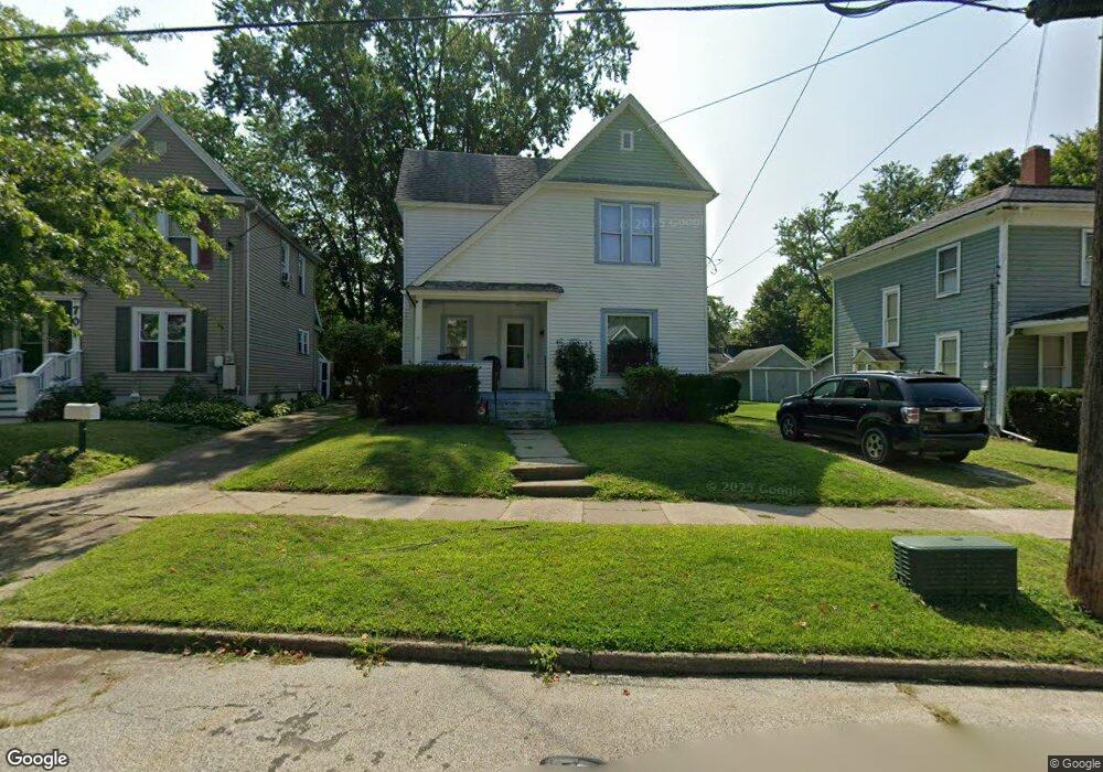
711 Maple Ave Conneaut, OH 44030
Estimated Value: $74,000 - $106,000
3
Beds
2
Baths
1,281
Sq Ft
$66/Sq Ft
Est. Value
About This Home
This home is located at 711 Maple Ave, Conneaut, OH 44030 and is currently estimated at $84,714, approximately $66 per square foot. 711 Maple Ave is a home located in Ashtabula County with nearby schools including Lakeshore Primary Elementary School, Gateway Elementary School, and Conneaut Middle School.
Ownership History
Date
Name
Owned For
Owner Type
Purchase Details
Closed on
Jun 2, 2010
Sold by
Faudree Thomas C and Temple Kari
Bought by
Drew Gary E
Current Estimated Value
Purchase Details
Closed on
Mar 11, 2010
Sold by
Benson James R
Bought by
Faudree Thomas C
Home Financials for this Owner
Home Financials are based on the most recent Mortgage that was taken out on this home.
Original Mortgage
$35,000
Interest Rate
5%
Mortgage Type
Unknown
Purchase Details
Closed on
Mar 28, 2007
Sold by
Us Bank Na
Bought by
Benson James R
Purchase Details
Closed on
Aug 23, 2006
Sold by
Mcguire Denis and Mcguire Monique
Bought by
Us Bank Na and Credit Based Asset Servicing & Securitiz
Create a Home Valuation Report for This Property
The Home Valuation Report is an in-depth analysis detailing your home's value as well as a comparison with similar homes in the area
Home Values in the Area
Average Home Value in this Area
Purchase History
| Date | Buyer | Sale Price | Title Company |
|---|---|---|---|
| Drew Gary E | $10,500 | Attorney | |
| Faudree Thomas C | $35,000 | Ashtabula Land Title | |
| Benson James R | $28,000 | Cornerstone Title Svcs Llc | |
| Us Bank Na | $30,000 | None Available |
Source: Public Records
Mortgage History
| Date | Status | Borrower | Loan Amount |
|---|---|---|---|
| Previous Owner | Faudree Thomas C | $35,000 |
Source: Public Records
Tax History
| Year | Tax Paid | Tax Assessment Tax Assessment Total Assessment is a certain percentage of the fair market value that is determined by local assessors to be the total taxable value of land and additions on the property. | Land | Improvement |
|---|---|---|---|---|
| 2024 | $1,058 | $14,460 | $1,820 | $12,640 |
| 2023 | $254 | $14,460 | $1,820 | $12,640 |
| 2022 | $133 | $11,100 | $1,400 | $9,700 |
| 2021 | $612 | $11,100 | $1,400 | $9,700 |
| 2020 | $612 | $11,100 | $1,400 | $9,700 |
| 2019 | $561 | $9,980 | $950 | $9,030 |
| 2018 | $536 | $9,980 | $950 | $9,030 |
| 2017 | $628 | $9,980 | $950 | $9,030 |
| 2016 | $714 | $14,600 | $1,400 | $13,200 |
| 2015 | $1,360 | $14,600 | $1,400 | $13,200 |
| 2014 | $639 | $14,600 | $1,400 | $13,200 |
| 2013 | $535 | $12,570 | $1,330 | $11,240 |
Source: Public Records
Map
Nearby Homes
- 745 Maple Ave
- 238 Whitney St
- 681 Madison St
- 536 Madison St
- 475 State St
- 474 Sherman St
- 18 Hillcrest Ct
- 375 Bliss Ave
- 450 Buffalo St
- 736 Lake Erie St
- 386 Washington St
- 210 W Main Rd
- 716 Chestnut St
- 284 Clay St
- 146 Nickle Plate Ave
- 202 W Main Rd Unit 132
- 202 W Main Rd Unit 93
- VL Center Rd
- 1145 Lake Rd
- 28 Lake Park Dr
Your Personal Tour Guide
Ask me questions while you tour the home.