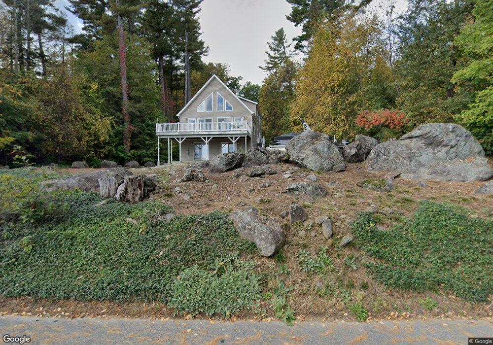
711 W Wakefield Blvd Winsted, CT 06098
Estimated Value: $274,000 - $816,000
2
Beds
1
Bath
1,015
Sq Ft
$448/Sq Ft
Est. Value
About This Home
This home is located at 711 W Wakefield Blvd, Winsted, CT 06098 and is currently estimated at $455,000, approximately $448 per square foot. 711 W Wakefield Blvd is a home located in Litchfield County.
Ownership History
Date
Name
Owned For
Owner Type
Purchase Details
Closed on
Aug 8, 2025
Sold by
Cohen Marilyn P
Bought by
Hanson Kurt and Hanson Abigail
Current Estimated Value
Home Financials for this Owner
Home Financials are based on the most recent Mortgage that was taken out on this home.
Original Mortgage
$155,000
Outstanding Balance
$117,225
Interest Rate
6.77%
Mortgage Type
Future Advance Clause Open End Mortgage
Estimated Equity
$337,775
Create a Home Valuation Report for This Property
The Home Valuation Report is an in-depth analysis detailing your home's value as well as a comparison with similar homes in the area
Home Values in the Area
Average Home Value in this Area
Purchase History
| Date | Buyer | Sale Price | Title Company |
|---|---|---|---|
| Hanson Kurt | $281,000 | -- |
Source: Public Records
Mortgage History
| Date | Status | Borrower | Loan Amount |
|---|---|---|---|
| Open | Hanson Kurt | $155,000 |
Source: Public Records
Tax History Compared to Growth
Tax History
| Year | Tax Paid | Tax Assessment Tax Assessment Total Assessment is a certain percentage of the fair market value that is determined by local assessors to be the total taxable value of land and additions on the property. | Land | Improvement |
|---|---|---|---|---|
| 2025 | $3,694 | $126,630 | $126,630 | $0 |
| 2024 | $4,826 | $177,170 | $126,630 | $50,540 |
| 2023 | $4,676 | $177,170 | $126,630 | $50,540 |
| 2022 | $3,105 | $92,580 | $55,060 | $37,520 |
| 2021 | $3,105 | $92,580 | $55,060 | $37,520 |
| 2020 | $3,105 | $92,580 | $55,060 | $37,520 |
| 2019 | $3,105 | $92,580 | $55,060 | $37,520 |
| 2018 | $3,105 | $92,580 | $55,060 | $37,520 |
| 2017 | $2,974 | $88,660 | $55,060 | $33,600 |
| 2016 | $3,112 | $92,790 | $55,060 | $37,730 |
| 2015 | $3,034 | $92,790 | $55,060 | $37,730 |
| 2014 | $2,961 | $92,790 | $55,060 | $37,730 |
Source: Public Records
Map
Nearby Homes
- 722 Lake Dr
- 105,107 E Mountain Rd
- 431 W Wakefield Blvd
- 843-845 (lots - 10A, E Wakefield Blvd
- 605 E Wakefield Blvd
- 819 E Wakefield Blvd
- 107 Peck Rd
- 440 Platt Hill Rd
- 469 Platt Hill Rd
- 393 Winchester Rd
- 114 Old Farms Rd
- 156 Lincoln Ave
- 00 Chapel Rd
- 23 Evergreen Rd
- 207 Ledge Dr
- 65 Woodside Cir Unit 65
- 90 Woodside Cir
- 103 Woodside Cir
- 98 Woodside Cir
- 174 Ledge Dr
- 726 W Wakefield Blvd
- 720 W Wakefield Blvd
- 107 Forest Ave
- 722 W Wakefield Blvd
- 712 W Wakefield Blvd
- 710 W Wakefield Blvd
- 710/11 W Wakefield Blvd
- 101 Forest Ave
- 714 W Wakefield Blvd
- 708 W Wakefield Blvd
- 716 W Wakefield Blvd
- 108 Forest Ave
- 715 W Wakefield Blvd
- 715 W Wakefield Blvd
- 117 Forest Ave
- 706 W Wakefield Blvd
- 718 W Wakefield Blvd
- 728 W Wakefield Blvd
- 729 W Wakefield Blvd
- 730 W Wakefield Blvd