Estimated Value: $309,000 - $425,826
4
Beds
4
Baths
2,850
Sq Ft
$133/Sq Ft
Est. Value
About This Home
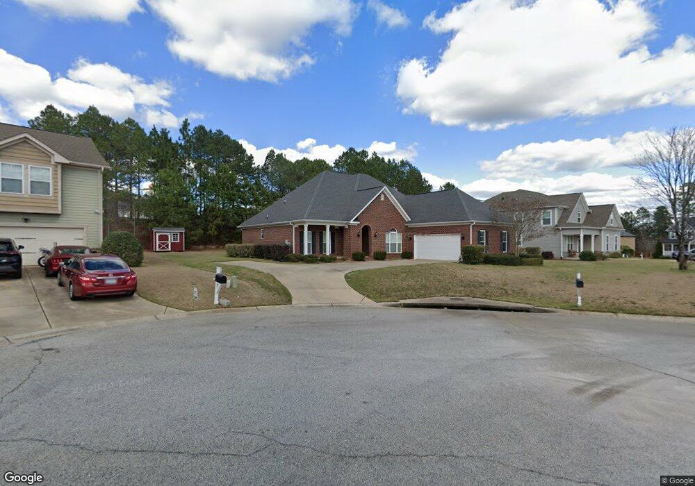
This home is located at 7110 Wethersfield Dr, Aiken, SC 29801 and is currently estimated at $377,707, approximately $132 per square foot. 7110 Wethersfield Dr is a home located in Aiken County with nearby schools including Graniteville Elementary School, Leavelle McCampbell Middle School, and Aiken Performing Arts Academy Charter.
Ownership History
Date
Name
Owned For
Owner Type
Purchase Details
Closed on
Aug 29, 2025
Sold by
Burchett Rickey S and Burchett Rick S
Bought by
Burchett Family Revocable Living Trust and Burchett
Current Estimated Value
Purchase Details
Closed on
Jun 28, 2010
Sold by
Ivey Residential Tr Llc
Bought by
Burchett Rick S and Burchett Diane G
Home Financials for this Owner
Home Financials are based on the most recent Mortgage that was taken out on this home.
Original Mortgage
$290,365
Interest Rate
4.83%
Mortgage Type
New Conventional
Create a Home Valuation Report for This Property
The Home Valuation Report is an in-depth analysis detailing your home's value as well as a comparison with similar homes in the area
Home Values in the Area
Average Home Value in this Area
Purchase History
| Date | Buyer | Sale Price | Title Company |
|---|---|---|---|
| Burchett Family Revocable Living Trust | -- | None Listed On Document | |
| Burchett Family Revocable Living Trust | -- | None Listed On Document | |
| Burchett Rick S | $290,365 | -- |
Source: Public Records
Mortgage History
| Date | Status | Borrower | Loan Amount |
|---|---|---|---|
| Previous Owner | Burchett Rick S | $290,365 |
Source: Public Records
Tax History
| Year | Tax Paid | Tax Assessment Tax Assessment Total Assessment is a certain percentage of the fair market value that is determined by local assessors to be the total taxable value of land and additions on the property. | Land | Improvement |
|---|---|---|---|---|
| 2025 | $1,283 | $11,910 | -- | -- |
| 2023 | $1,285 | $11,910 | $1,360 | $263,680 |
| 2022 | $1,252 | $11,910 | $0 | $0 |
| 2021 | $1,255 | $11,910 | $0 | $0 |
| 2020 | $1,106 | $10,540 | $0 | $0 |
| 2019 | $1,106 | $10,540 | $0 | $0 |
| 2018 | $1,104 | $10,540 | $1,360 | $9,180 |
| 2017 | $1,051 | $0 | $0 | $0 |
| 2016 | $1,052 | $0 | $0 | $0 |
| 2015 | $1,200 | $0 | $0 | $0 |
| 2014 | $1,202 | $0 | $0 | $0 |
| 2013 | -- | $0 | $0 | $0 |
Source: Public Records
Map
Nearby Homes
- 220 Donnington Ct
- 238 Marstrand Cir
- 256 Marstrand Cir
- 196 Marstrand Cir
- 182 Marstrand Cir
- The Hollins Plan at Providence at Trolley Run Station
- The Yarmouth Plan at Providence at Trolley Run Station
- The Jefferson Plan at Providence at Trolley Run Station
- The Kershaw Plan at Providence at Trolley Run Station
- The Easton Plan at Providence at Trolley Run Station
- The Tyndall Plan at Providence at Trolley Run Station
- The Lambert Plan at Providence at Trolley Run Station
- The Juniper II Plan at Providence at Trolley Run Station
- The Sadler Plan at Providence at Trolley Run Station
- 347 Marstrand Cir
- 166 Marstrand Cir
- 154 Marstrand Cir
- Bentcreek II Plan at Providence at Trolley Run Station
- Harper II Plan at Providence at Trolley Run Station
- Bailey II Plan at Providence at Trolley Run Station
- 7098 Wethersfield Dr
- 7124 Wethersfield Dr
- LOT 14 Wethersfield Dr
- LOT 13 Wethersfield Dr
- Lot 26 Wethersfield Dr
- Lot 18 Wethersfield Dr
- 7126 Wethersfield Dr
- 7066 Wethersfield Dr
- 7050 Wethersfield Dr
- 7060 Wethersfield Dr
- 7020 Wethersfield Dr
- 7107 Wethersfield Dr
- 7123 Wethersfield Dr
- 7103 Wethersfield Dr
- 7091 Wethersfield Dr
- 7012 Wethersfield Dr
- 7097 Wethersfield Dr
- 7087 Wethersfield Dr
- 7083 Wethersfield Dr
- 7073 Wethersfield Dr
Your Personal Tour Guide
Ask me questions while you tour the home.