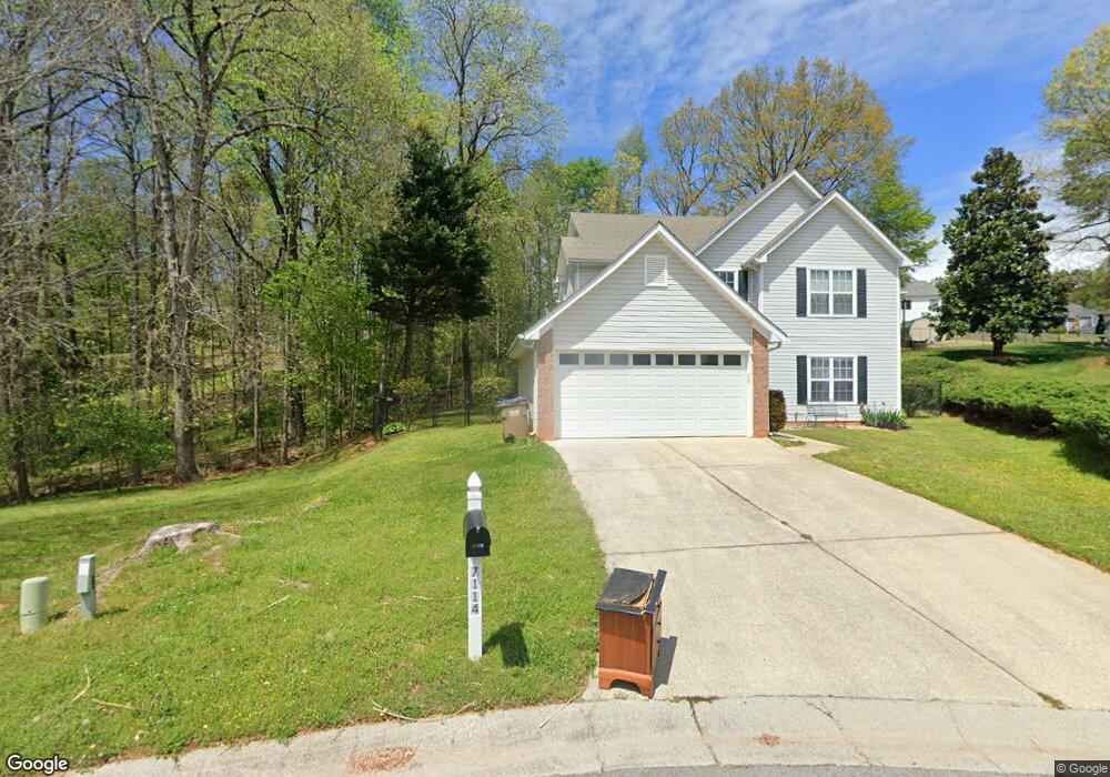
7114 Independence Dr Flowery Branch, GA 30542
Estimated Value: $327,540 - $363,000
3
Beds
3
Baths
1,809
Sq Ft
$190/Sq Ft
Est. Value
About This Home
This home is located at 7114 Independence Dr, Flowery Branch, GA 30542 and is currently estimated at $344,385, approximately $190 per square foot. 7114 Independence Dr is a home located in Hall County with nearby schools including Flowery Branch Elementary School, West Hall Middle School, and West Hall High School.
Ownership History
Date
Name
Owned For
Owner Type
Purchase Details
Closed on
Jul 28, 2004
Sold by
Cendant Mobility Financial Corp
Bought by
Meadows Cristy K
Current Estimated Value
Home Financials for this Owner
Home Financials are based on the most recent Mortgage that was taken out on this home.
Original Mortgage
$124,200
Outstanding Balance
$62,568
Interest Rate
6.24%
Mortgage Type
New Conventional
Estimated Equity
$281,817
Purchase Details
Closed on
Jul 30, 1998
Sold by
Bowen & Bowen Constr Co Inc
Bought by
Weathers Clint A
Home Financials for this Owner
Home Financials are based on the most recent Mortgage that was taken out on this home.
Original Mortgage
$98,000
Interest Rate
6.97%
Mortgage Type
New Conventional
Purchase Details
Closed on
Dec 5, 1997
Sold by
Sf Properties Iv Inc
Bought by
Bowen And Bowen Construction Co Inc
Purchase Details
Closed on
Mar 1, 1997
Create a Home Valuation Report for This Property
The Home Valuation Report is an in-depth analysis detailing your home's value as well as a comparison with similar homes in the area
Home Values in the Area
Average Home Value in this Area
Purchase History
| Date | Buyer | Sale Price | Title Company |
|---|---|---|---|
| Meadows Cristy K | $138,000 | -- | |
| Cendant Mobility Financial Corp | $138,000 | -- | |
| Weathers Clint A | $108,900 | -- | |
| Bowen And Bowen Construction Co Inc | $159,300 | -- | |
| -- | $60,000 | -- |
Source: Public Records
Mortgage History
| Date | Status | Borrower | Loan Amount |
|---|---|---|---|
| Open | Cendant Mobility Financial Corp | $124,200 | |
| Previous Owner | Weathers Clint A | $98,000 |
Source: Public Records
Tax History Compared to Growth
Tax History
| Year | Tax Paid | Tax Assessment Tax Assessment Total Assessment is a certain percentage of the fair market value that is determined by local assessors to be the total taxable value of land and additions on the property. | Land | Improvement |
|---|---|---|---|---|
| 2024 | $3,163 | $113,240 | $16,280 | $96,960 |
| 2023 | $2,214 | $106,760 | $16,280 | $90,480 |
| 2022 | $2,248 | $87,920 | $16,280 | $71,640 |
| 2021 | $2,112 | $81,240 | $16,280 | $64,960 |
| 2020 | $1,755 | $66,000 | $13,560 | $52,440 |
| 2019 | $1,753 | $65,360 | $10,480 | $54,880 |
| 2018 | $1,513 | $54,960 | $10,480 | $44,480 |
| 2017 | $1,532 | $54,320 | $10,480 | $43,840 |
| 2016 | $1,096 | $40,320 | $3,440 | $36,880 |
| 2015 | $1,046 | $40,320 | $3,440 | $36,880 |
| 2014 | $1,046 | $42,691 | $3,440 | $39,251 |
Source: Public Records
Map
Nearby Homes
- 6421 Kettle Creek Way
- 6300 Jones Rd
- 6224 Germantown Dr
- 6005 Bateau Dr
- 6115 Stella Light Dr
- 6578 Above Tide Place
- 5751 Turnstone Trail
- 6002 Catamaran Ct
- 5714 Turnstone Trail
- 5761 Screech Owl Dr
- 6474 Portside Way
- 6461 Topside Ave
- 6457 Topside Ave
- 6243 Shoreview Cir
- The Spring Hollow Plan at Rose Harbor
- The Danville Plan at Rose Harbor
- The Spring Hill Plan at Rose Harbor
- The Richmond Plan at Rose Harbor
- 5972 McEver Rd
- 7110 Independence Dr
- 7111 Independence Dr
- 6409 Kettle Creek Way
- 6506 Germantown Dr
- 7106 Independence Dr
- 6405 Kettle Creek Way
- 7107 Independence Dr
- 0 Independence Dr Unit 7026664
- 0 Independence Dr Unit 8856246
- 0 Independence Dr Unit 7570836
- 6510 Germantown Dr
- 7076 Valley Forge Dr
- 6514 Germantown Dr
- 7101 Independence Dr
- 7101 Independence Dr Unit GA12333
- 7101 Independence Dr Unit Ga1233
- 6417 Kettle Creek Way
- 7102 Independence Dr Unit Ga1285
- 7102 Independence Dr
- 7102 Independence Dr Unit GA12859