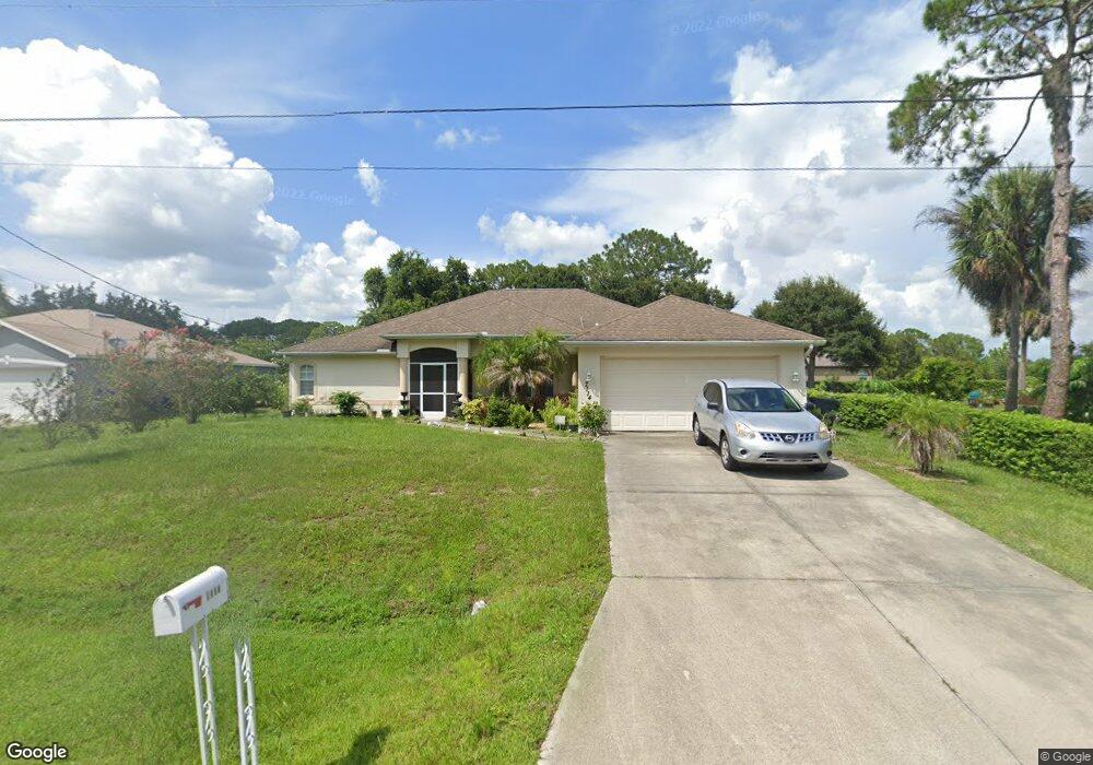
7114 Paragon Rd North Port, FL 34291
Estimated Value: $312,464 - $356,000
3
Beds
2
Baths
1,987
Sq Ft
$172/Sq Ft
Est. Value
About This Home
This home is located at 7114 Paragon Rd, North Port, FL 34291 and is currently estimated at $341,366, approximately $171 per square foot. 7114 Paragon Rd is a home located in Sarasota County with nearby schools including Glenallen Elementary School, North Port High School, and Heron Creek Middle School.
Ownership History
Date
Name
Owned For
Owner Type
Purchase Details
Closed on
Mar 11, 2005
Sold by
Residential Development Corp
Bought by
Smith Vinnette H
Current Estimated Value
Home Financials for this Owner
Home Financials are based on the most recent Mortgage that was taken out on this home.
Original Mortgage
$164,250
Outstanding Balance
$83,215
Interest Rate
5.6%
Mortgage Type
Purchase Money Mortgage
Estimated Equity
$258,151
Purchase Details
Closed on
Feb 27, 2004
Sold by
Garden Edwin A and Garden Beverly D
Bought by
Residential Dev Corp
Create a Home Valuation Report for This Property
The Home Valuation Report is an in-depth analysis detailing your home's value as well as a comparison with similar homes in the area
Home Values in the Area
Average Home Value in this Area
Purchase History
| Date | Buyer | Sale Price | Title Company |
|---|---|---|---|
| Smith Vinnette H | $172,900 | -- | |
| Residential Dev Corp | $8,500 | -- |
Source: Public Records
Mortgage History
| Date | Status | Borrower | Loan Amount |
|---|---|---|---|
| Open | Smith Vinnette H | $164,250 |
Source: Public Records
Tax History Compared to Growth
Tax History
| Year | Tax Paid | Tax Assessment Tax Assessment Total Assessment is a certain percentage of the fair market value that is determined by local assessors to be the total taxable value of land and additions on the property. | Land | Improvement |
|---|---|---|---|---|
| 2024 | $1,908 | $114,431 | -- | -- |
| 2023 | $1,908 | $111,098 | $0 | $0 |
| 2022 | $1,859 | $107,862 | $0 | $0 |
| 2021 | $1,820 | $104,720 | $0 | $0 |
| 2020 | $1,769 | $103,274 | $0 | $0 |
| 2019 | $1,710 | $100,952 | $0 | $0 |
| 2018 | $1,569 | $99,070 | $0 | $0 |
| 2017 | $1,531 | $97,032 | $0 | $0 |
| 2016 | $1,522 | $162,200 | $5,700 | $156,500 |
| 2015 | $1,532 | $137,800 | $4,000 | $133,800 |
| 2014 | $1,503 | $92,242 | $0 | $0 |
Source: Public Records
Map
Nearby Homes
- 0 Minardi St Unit MFRC7512307
- 7192 N Paragon Rd
- 2821 Embassy Rd
- Lot 7 Paragon Rd
- Lot 8 Paragon Rd
- 2713 Embassy Rd
- 0 Callaghan Ln Unit MFRC7512528
- 0 Callaghan Ln Unit MFRC7504542
- 0 Callaghan Ln Unit MFRC7501818
- 7478 Paragon Rd
- 0 Cordova Terrace Unit MFRC7514596
- 0 Cordova Terrace Unit MFRC7514594
- 0 Cordova Terrace Unit MFRC7512529
- 0 Cordova Terrace Unit MFRC7510712
- 0 Cordova Terrace Unit MFRC7504532
- 0 Cordova Terrace Unit MFRC7504531
- 0 Cordova Terrace Unit MFRN6135655
- 3339 Duar Terrace
- 7587 Jayman Rd
- 0 Jayman Rd Unit MFRA4664836
- 7140 Paragon Rd
- 0 N Paragon Rd
- 7103 Meroni Blvd
- 7062 Paragon Rd
- 7131 Meroni Blvd
- 7220 Minardi St
- 7145 Meroni Blvd
- Rockman St
- Rockman St
- Rockman St
- 7067 Boulevard
- 7192 Paragon Rd
- 7067 Meroni Blvd
- Lot 8 Minardi St
- 7159 Meroni Blvd
- Rogue St
- 0 Minardi St Unit N5913858
- 0 Minardi St Unit C7241017
- 0 Minardi St Unit C7238945