NOT LISTED FOR SALE

Estimated Value: $647,000 - $672,000

1.01 Acres
$655,966 Price per Acre
43,996 Sq Ft Lot

Last Sold January 31, 2014

Last sale price $40,000 $26 Per Sq Ft

Est. 1,556% increase in value since last sale

Current estimated payment $4,245/month

119 Days on Market

Highlights

  • Partially Wooded Lot
  • Corner Lot
  • Grass Covered Lot
  • Hickory Flat Elementary School Rated A

About This Lot

As of January 2014

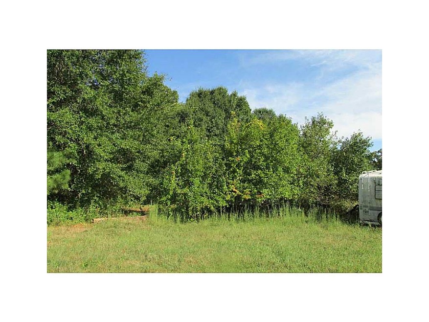
Hard to find, fabulous 1.01 acre lot in Hickory Flat. Level and wooded. Room for pool. Top schools. Convenient to shopping, gas, dining, 140, and 575. Driveway and all utilities in place. New build across the street. Go see it today.

Last Agent to Sell the Property

David Johnson

Atlanta Communities License #175435 Listed on: 09/17/2013

Atlanta Communities

Co-Listed By

Jane Johnson

Atlanta Communities License #334972

Last Buyer's Agent

TAMMY S ROBERTS

Path & Post Real Estate License #250902

Property Details

Property Type

  • Land

Est. Annual Taxes

  • $240

Lot Details

  • 1.01 Acre Lot
  • Corner Lot
  • Level Lot
  • Partially Wooded Lot
  • Grass Covered Lot
  • Property is zoned SF

Schools

  • Hickory Flat - Cherokee Elementary School
  • Dean Rusk Middle School
  • Sequoyah High School

Utilities

  • Septic Tank
  • Phone Available
  • Cable TV Available

Listing and Financial Details

  • Assessor Parcel Number 7116VaughnRD

Property Details

Property Type

Land

Est. Annual Taxes

$240

Lot Details

0

Listing Details

  • Standard Status: Closed
  • Property Type: Land
  • MLS Status: Closed
  • Property Sub Type: Single Family Residence
  • Special Features: None

Property Details

  • Property: Res Developed Lots

Utilities

  • Sewer: Septic Tank
  • Utilities: Cable Available, Electricity Available, Phone Available, Water Available

Schools

  • Elementary School: Hickory Flat - Cherokee
  • Middle School: Dean Rusk
  • High School: Sequoyah

Lot Info

  • Acres: 1.0100
  • Current Zoning: SF
  • Deed Book: 2651
  • Deed Page: 188
  • Lot Features: Corner Lot, Curbs & Gutters, Level
  • Lot Dimensions: approx 1.01 acres
  • Parcel Number: 7116VaughnRD
  • Price Acre Dollar: 39603.00
  • Property Attached Yn: No

Tax Info

  • Taxes: 240.00
  • Assessor Parcel Number: 002N03-00000-013-000-0000
  • Close Date: 2014-01-31
  • Tax Year: 2012

MLS Schools

  • Elementary School: Hickory Flat - Cherokee
  • High School: Sequoyah
  • Middle School: Dean Rusk

Ownership History

Date Name Owned For Owner Type

Purchase Details

Listed on
Sep 17, 2013
Closed on
Jan 31, 2014
Sold by
Lowe Ricky M
Bought by
Hunt Andrew
Seller's Agent
David Johnson
Atlanta Communities
Buyer's Agent
TAMMY S ROBERTS
Path & Post Real Estate
List Price
$45,000
Sold Price
$40,000
Premium/Discount to List
-$5,000
-11.11%
Current Estimated Value
$662,526

Home Financials for this Owner

Home Financials are based on the most recent Mortgage that was taken out on this home.
Estimated Appreciation
$622,526
Avg. Annual Appreciation
27.95%
Original Mortgage
$175,978
Interest Rate
4.24%
Mortgage Type
New Conventional

Purchase Details

Closed on
Feb 20, 1997
Sold by
Matthews Alvin
Bought by
Lowe Ricky Ladonna
Source: Public Records

Similar Properties in Canton, GA

  • 209 Old Cumming Dr, Canton, GA 30114

    $600,000

    • Land
    • 1.12 Acres
    • $535,714 per Acre
    • 209 Old Cumming Dr
    • Canton, GA

    This is part of approximately 14 Acre assemblage of relatively level land with no topographical challenges. Commercial buildings and residential homes are on the property. Land sits high with excellent visibility on Hwy 20. Approx. 1500 ft of road frontage on Old Cumming Dr, Bishop Dr. and Hwy 20. Industrial grade cul-de-sac for property use capable of handling 18 wheeler trucks and trailers.

    JILL A DENNIS ERA Sunrise Realty

    Section Image
  • 229 Old Cumming Dr, Canton, GA 30114

    $600,000

    • Land
    • 0.76 Acre
    • $789,474 per Acre
    • 229 Old Cumming Dr
    • Canton, GA

    This is part of approximately 14 Acre assemblage of relatively level land with no topographical challenges. Commercial buildings and residential homes are on the property. Land sits high with excellent visibility on Hwy 20. Approx. 1200 ft of road frontage on Old Cumming Dr, Bishop Dr. and Hwy 20. Industrial grade cul-de-sac for property use capable of handling 18 wheeler trucks and trailers.

    JILL A DENNIS ERA Sunrise Realty

    Section Image

Range of Values:

Collateral Analytics

Collateral Analytics Collateral Analytics AVMs (Automated Valuation Model) employ a number of statistical approaches combined with neighborhood-specific comparable selection guarantees the most up-to-date and precise valuations.

Not Available

Collateral Analytics does not have data for the current month. Please view the chart for historical values.

ICE

ICE Mortgage Technology ICE Mortgage Technology’s AVM (Automated Valuation Model) is a state-of-the-art online residential property valuation tool that provides a quick and accurate estimate of the value of almost any home in the U.S.

Not Available

ICE Mortgage Technology does not have data for the current month. Please view the chart for historical values.

First American

First American First American Data & Analytics’ next-generation AVM combines unrivaled data assets with a blended ensemble of valuation models to produce highly accurate, reliable valuations you can trust.

Not Available

First American does not have data for the current month. Please view the chart for historical values.

Quantarium

Quantarium Quantarium’s valuation service, repeatedly proven the industry’s most accurate and comprehensive, is supercharged with a self-learning and auto-tuning AI engine that continually becomes smarter and more accurate as it processes daily inputs from the industry’s leading RE data lake.

Not Available

Quantarium does not have data for the current month. Please view the chart for historical values.

Average Value
Not Available
List Price
Sold Price
Create a Home Valuation Report for This Property
The Home Valuation Report is an in-depth analysis detailing your home's value as well as a comparison with similar homes in the area

Home Values in the Area

Source: Public Records

Average Home Value in this Area


Source: Public Records

Purchase History

Date Buyer Sale Price Title Company
Hunt Andrew $40,000 --
Lowe Ricky Ladonna $96,000 --
Source: Public Records

Mortgage History

Date Status Borrower Loan Amount
Open Hunt Andrew M $144,000
Closed Hunt Andrew M $184,000
Closed Hunt Andrew $175,978
Previous Owner Lowe Ricky M $89,800
Closed Lowe Ricky Ladonna $0
Source: Public Records

Property History

Date Event Price Change Sq Ft Price
01/31/2014 01/31/14 Sold $40,000 -11.1% $26 / Sq Ft
01/14/2014 01/14/14 Pending -- -- --
09/17/2013 09/17/13 For Sale $45,000 -- $30 / Sq Ft
Source: First Multiple Listing Service (FMLS)

Tax History Compared to Growth

Source: Public Records

Tax History

Year Tax Paid Tax Assessment Tax Assessment Total Assessment is a certain percentage of the fair market value that is determined by local assessors to be the total taxable value of land and additions on the property. Land Improvement
2024 $6,649 $280,880 $22,000 $258,880
2023 $6,204 $280,400 $22,000 $258,400
2022 $5,999 $246,680 $17,200 $229,480
2021 $5,790 $216,240 $17,200 $199,040
2020 $5,317 $195,640 $17,200 $178,440
2019 $5,063 $184,680 $16,000 $168,680
2018 $4,711 $168,360 $16,000 $152,360
2017 $4,647 $410,200 $16,000 $148,080
2016 $4,697 $403,300 $16,000 $145,320
2015 $4,188 $356,100 $16,000 $126,440
2014 $236 $20,000 $8,000 $0
Source: Public Records

Agents Affiliated with this Home

  • Section Image
  • Section Image
  • Section Image
See All Agents

Map

Source: First Multiple Listing Service (FMLS)

MLS Number: 5200174

First Multiple Listing Service (FMLS)

APN: 002N03-00000-013-000-0000