
71185 Kutafya Rd Anchor Point, AK 99556
Estimated payment $2,935/month
Highlights
- Horses Allowed On Property
- Deck
- Wood Flooring
- Property fronts an inlet
- Wood Burning Stove
- Private Yard
About This Home
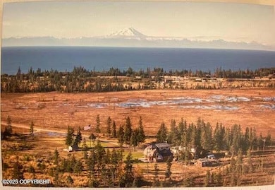
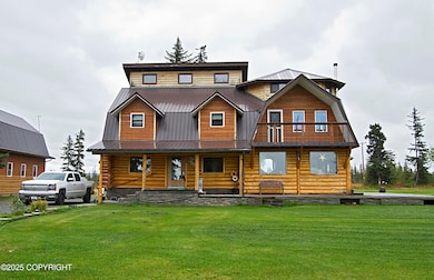
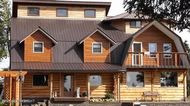
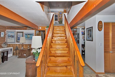
Hankering for a homestead feel with a beautiful natural log home and a shop that is truly over the top? This home has been so immaculately cared for and it just feels sooooo comfortable. Logs from the property were cured and used to build the home adding wood accents throughout. A great layout with big living area and kitchen on the main level and bedrooms upstairs. 8+ acres of PRIVACY and VIEW!As you approach this home at the end of the road, you know you are in for a treat. Stone accents, trex decks and walkways, beautiful well maintained logs...yes this is nice. The Seller is retired and would prefer to include almost all of the furnishings so this could be a "bring your suitcase and move in home." Lots of room to entertain and spread out on the main level. AND lots of windows that let in so much natural light. Did I mention Cook Inlet views as well? Second level features a BIG master suite, two other bedrooms and full bath. And a surprise third level, with 2 more bedrooms and plumbing stubbed for a third bath. The detached shop is a dream come true for woodworker, hobbyist, etc. Plus there is a huge upper area that could be converted for whatever your heart desires. the shop features in floor heat and foam insulation, so you can work out there in any season. The acreage is flat, the garden is lovely and there is plenty of room to park all of your toys. Come see why this has been such a great home and now it can be yours!
Home Details
Home Type
- Single Family
Est. Annual Taxes
- $739
Year Built
- Built in 1983
Lot Details
- 8.82 Acre Lot
- Property fronts an inlet
- Private Yard
- Property is zoned UNZ, Not Zoned
Parking
- 2 Car Garage
Home Design
- Pillar, Post or Pier Foundation
- Wood Frame Construction
- Metal Roof
- Log Siding
Interior Spaces
- 2,945 Sq Ft Home
- Ceiling Fan
- Fireplace
- Wood Burning Stove
- Family Room
- Den
- Fire and Smoke Detector
- Washer and Dryer
- Property Views
Kitchen
- Oven or Range
- Microwave
- Free-Standing Freezer
- Dishwasher
Flooring
- Wood
- Carpet
- Ceramic Tile
Bedrooms and Bathrooms
- 3 Bedrooms
- 2 Full Bathrooms
Outdoor Features
- Deck
- Shed
Schools
- Chapman Elementary And Middle School
- Homer High School
Horse Facilities and Amenities
- Horses Allowed On Property
Utilities
- Heating Available
- Electricity To Lot Line
- Private Water Source
- Well
- Water Softener
- Septic Tank
Community Details
- Built by Richard Stapel
Map
Home Values in the Area
Average Home Value in this Area
Tax History
| Year | Tax Paid | Tax Assessment Tax Assessment Total Assessment is a certain percentage of the fair market value that is determined by local assessors to be the total taxable value of land and additions on the property. | Land | Improvement |
|---|---|---|---|---|
| 2025 | $192 | $425,700 | $58,600 | $367,100 |
| 2024 | $96 | $368,600 | $55,700 | $312,900 |
| 2023 | $220 | $343,100 | $46,400 | $296,700 |
| 2022 | $0 | $308,600 | $39,600 | $269,000 |
| 2021 | $220 | $287,900 | $38,400 | $249,500 |
| 2020 | $0 | $246,200 | $38,400 | $207,800 |
| 2019 | $0 | $297,200 | $29,700 | $267,500 |
| 2018 | $220 | $369,700 | $29,700 | $340,000 |
| 2017 | -- | $281,500 | $29,700 | $251,800 |
| 2016 | -- | $265,200 | $29,700 | $235,500 |
| 2015 | -- | $268,700 | $29,700 | $239,000 |
| 2014 | -- | $272,100 | $29,700 | $242,400 |
Property History
| Date | Event | Price | List to Sale | Price per Sq Ft |
|---|---|---|---|---|
| 10/28/2025 10/28/25 | Pending | -- | -- | -- |
| 09/15/2025 09/15/25 | For Sale | $545,000 | -- | $185 / Sq Ft |
Purchase History
| Date | Type | Sale Price | Title Company |
|---|---|---|---|
| Warranty Deed | -- | -- |
Mortgage History
| Date | Status | Loan Amount | Loan Type |
|---|---|---|---|
| Open | $180,000 | Commercial |
Source: Alaska Multiple Listing Service
MLS Number: 25-11699
APN: 165-083-12
Disclaimer: Certain information contained herein is derived from information provided by parties other than Homes.com. All information provided is deemed reliable, but is not guaranteed to be accurate and should be independently verified.
![]() The listing content relating to real estate for sale on this web site comes in part from the IDX Program of Alaska Multiple Listing Service, Inc. (AK MLS). Real estate listings held by brokerage firms other than Ten-X are marked with either the listing brokerage’s logo or the AK MLS logo and information about them includes the name of the listing brokerage. All information is deemed reliable but is not guaranteed and should be independently verified for accuracy. Copyright 2025 Alaska Multiple Listing Service, Inc. All rights reserved.
The listing content relating to real estate for sale on this web site comes in part from the IDX Program of Alaska Multiple Listing Service, Inc. (AK MLS). Real estate listings held by brokerage firms other than Ten-X are marked with either the listing brokerage’s logo or the AK MLS logo and information about them includes the name of the listing brokerage. All information is deemed reliable but is not guaranteed and should be independently verified for accuracy. Copyright 2025 Alaska Multiple Listing Service, Inc. All rights reserved.
- 30076 Whiskey Gulch Beach Rem SW
- 71265 Kallman Dr
- 70859 Tall Tree Ave
- 000 Tall Tree Ave
- 67381 Stoddard Ave
- 31885 Whiskey Gulch St
- 72278 Valleyside Ave
- 000 Wild Cotton Rd
- 31890 Whiskey Gulch St
- 70820 Isabelle Rd
- 31435 Rorath St
- 32425 Sterling Hwy
- 70430 Tall Tree Ave
- 31580 Hannah Rene Rd
- 34581 N Fork Rd
- 30162 Right Bank St
- 31315 Birch Haven Rd
- 32879 Shorebird Ln
- 32775 Shorebird Ln
- 69231 Tanners Trail Rd
