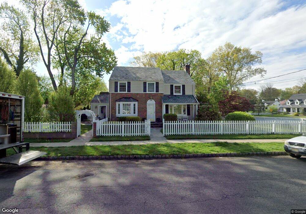
712 Harding St Westfield, NJ 07090
Estimated Value: $994,057 - $1,277,000
--
Bed
--
Bath
1,958
Sq Ft
$574/Sq Ft
Est. Value
About This Home
This home is located at 712 Harding St, Westfield, NJ 07090 and is currently estimated at $1,123,514, approximately $573 per square foot. 712 Harding St is a home located in Union County with nearby schools including Washington Elementary School, Edison Intermediate School, and Westfield Senior High School.
Ownership History
Date
Name
Owned For
Owner Type
Purchase Details
Closed on
Sep 17, 2001
Sold by
Sissano Seraphine A M
Bought by
Wiggins Brett Eric and Wiggins Sheila Marie Raftery
Current Estimated Value
Home Financials for this Owner
Home Financials are based on the most recent Mortgage that was taken out on this home.
Original Mortgage
$35,400
Outstanding Balance
$13,794
Interest Rate
6.98%
Mortgage Type
Credit Line Revolving
Estimated Equity
$1,109,720
Create a Home Valuation Report for This Property
The Home Valuation Report is an in-depth analysis detailing your home's value as well as a comparison with similar homes in the area
Home Values in the Area
Average Home Value in this Area
Purchase History
| Date | Buyer | Sale Price | Title Company |
|---|---|---|---|
| Wiggins Brett Eric | $477,000 | -- |
Source: Public Records
Mortgage History
| Date | Status | Borrower | Loan Amount |
|---|---|---|---|
| Open | Wiggins Brett Eric | $35,400 | |
| Open | Wiggins Brett Eric | $381,600 |
Source: Public Records
Tax History Compared to Growth
Tax History
| Year | Tax Paid | Tax Assessment Tax Assessment Total Assessment is a certain percentage of the fair market value that is determined by local assessors to be the total taxable value of land and additions on the property. | Land | Improvement |
|---|---|---|---|---|
| 2025 | $14,850 | $659,400 | $452,200 | $207,200 |
| 2024 | $14,546 | $659,400 | $452,200 | $207,200 |
| 2023 | $14,546 | $659,400 | $452,200 | $207,200 |
| 2022 | $14,243 | $659,400 | $452,200 | $207,200 |
| 2021 | $14,263 | $659,400 | $452,200 | $207,200 |
| 2020 | $14,003 | $648,900 | $452,200 | $196,700 |
| 2019 | $13,951 | $648,900 | $452,200 | $196,700 |
| 2018 | $13,527 | $145,500 | $82,800 | $62,700 |
| 2017 | $13,453 | $145,500 | $82,800 | $62,700 |
| 2016 | $13,137 | $145,500 | $82,800 | $62,700 |
| 2015 | $12,875 | $145,500 | $82,800 | $62,700 |
| 2014 | $12,450 | $145,500 | $82,800 | $62,700 |
Source: Public Records
Map
Nearby Homes
- 529 Benson Place
- 806 Saint Marks Ave
- 7 Folkstone Dr
- 764 Fairacres Ave
- 629 Tremont Ave
- 519 3rd Ave
- 131 Wells St
- 105 Chestnut Ct Unit 3
- 500 Maple Ct Unit 500
- 820 E Broad St
- 401 Brookside Place
- 4 Cedar St
- 534 E Broad St
- 339 2nd Ave
- 305 Cedar St
- 565 Willow Ave
- 410 Lenox Ave
- 128 Woodland Ave
- 684 Gallows Hill Rd
- 223 5th Ave
- 407 Benson Place
- 413 Benson Place
- 720 Harding St
- 345 Benson Place
- 503 Benson Place
- 726 Harding St
- 719 Harding St
- 341 Benson Place
- 721 Harding St
- 507 Benson Place
- 728 Harding St
- 337 Benson Place
- 723 Harding St
- 711 Coolidge St
- 408 Salter Place
- 404 Salter Place
- 511 Benson Place
- 412 Salter Place
- 730 Harding St
- 727 Harding St