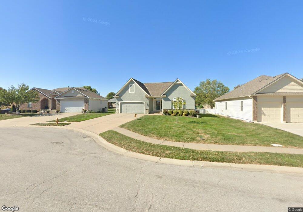
712 Redtop Ln Raymore, MO 64083
Estimated Value: $334,346 - $397,000
2
Beds
2
Baths
1,372
Sq Ft
$271/Sq Ft
Est. Value
About This Home
This home is located at 712 Redtop Ln, Raymore, MO 64083 and is currently estimated at $371,337, approximately $270 per square foot. 712 Redtop Ln is a home located in Cass County with nearby schools including Stonegate Elementary School, Raymore-Peculiar South Middle School, and Raymore-Peculiar Senior High School.
Ownership History
Date
Name
Owned For
Owner Type
Purchase Details
Closed on
Jun 2, 2023
Sold by
Langham Jayne
Bought by
Jayne A Langham Intervivos Trust
Current Estimated Value
Purchase Details
Closed on
Jul 30, 2010
Sold by
Wiley Enteprises Llc
Bought by
Langham Jayne
Purchase Details
Closed on
Sep 26, 2005
Sold by
Otis Llc
Bought by
Wiley Enterprises Llc
Home Financials for this Owner
Home Financials are based on the most recent Mortgage that was taken out on this home.
Original Mortgage
$160,000
Interest Rate
5.76%
Mortgage Type
Future Advance Clause Open End Mortgage
Create a Home Valuation Report for This Property
The Home Valuation Report is an in-depth analysis detailing your home's value as well as a comparison with similar homes in the area
Home Values in the Area
Average Home Value in this Area
Purchase History
| Date | Buyer | Sale Price | Title Company |
|---|---|---|---|
| Jayne A Langham Intervivos Trust | -- | None Listed On Document | |
| Langham Jayne | -- | -- | |
| Wiley Enterprises Llc | -- | -- |
Source: Public Records
Mortgage History
| Date | Status | Borrower | Loan Amount |
|---|---|---|---|
| Previous Owner | Wiley Enterprises Llc | $160,000 |
Source: Public Records
Tax History
| Year | Tax Paid | Tax Assessment Tax Assessment Total Assessment is a certain percentage of the fair market value that is determined by local assessors to be the total taxable value of land and additions on the property. | Land | Improvement |
|---|---|---|---|---|
| 2025 | $3,763 | $52,350 | $6,190 | $46,160 |
| 2024 | $3,763 | $46,300 | $5,630 | $40,670 |
| 2023 | $3,763 | $46,300 | $5,630 | $40,670 |
| 2022 | $3,355 | $41,010 | $5,630 | $35,380 |
| 2021 | $3,356 | $41,010 | $5,630 | $35,380 |
| 2020 | $3,359 | $40,330 | $5,630 | $34,700 |
| 2019 | $3,243 | $40,330 | $5,630 | $34,700 |
| 2018 | $2,936 | $35,260 | $4,690 | $30,570 |
| 2017 | $2,658 | $35,260 | $4,690 | $30,570 |
| 2016 | $2,658 | $33,130 | $4,690 | $28,440 |
| 2015 | $2,660 | $33,130 | $4,690 | $28,440 |
| 2014 | $2,661 | $33,130 | $4,690 | $28,440 |
| 2013 | -- | $33,130 | $4,690 | $28,440 |
Source: Public Records
Map
Nearby Homes
- 709 Bluestem Ct
- 1717 Overbrook Ln
- 603 Old Paint Rd
- 300 Dean Ave
- 415 Woodview Dr
- 1519 Colt Cir
- 1510 Colt Cir
- 414 Eagle Glen Dr
- 411 Eagle Glen Dr
- 1608 Cody Dr
- 212 S Huntsman Blvd
- 817 Shane Ct
- 18795 Sunrise Dr
- 18806 Sunrise Dr
- 1601 Stasi Ave
- 1103 Carlisle Dr
- 1105 Creekside Ct
- 112 S Westglen Dr
- 18867 Sunrise Dr
- 110 S Westglen Dr
- 710 Redtop Ln
- 714 Redtop Ln
- 707 Bluestem Ct
- 708 Redtop Ln
- 716 Redtop Ln
- 711 Bluestem Ct
- 713 Redtop Ln
- 711 Redtop Ln
- 705 Bluestem Ct
- 715 Redtop Ln
- 717 Redtop Ln
- 716 Gamma Grass Place
- 714 Gamma Grass Place
- 718 Gamma Grass Place
- 706 Bluestem Ct
- 712 Gamma Grass Place
- 1917 Prairie Grass Dr
- 1915 Prairie Grass Dr
- 704 Bluestem Ct
- 1921 Prairie Grass Dr
Your Personal Tour Guide
Ask me questions while you tour the home.