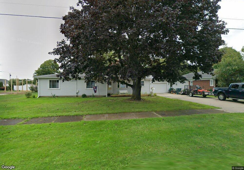
712 Sandusky St Conneaut, OH 44030
Estimated Value: $113,000 - $172,000
2
Beds
2
Baths
1,120
Sq Ft
$135/Sq Ft
Est. Value
About This Home
This home is located at 712 Sandusky St, Conneaut, OH 44030 and is currently estimated at $151,393, approximately $135 per square foot. 712 Sandusky St is a home located in Ashtabula County with nearby schools including Lakeshore Primary Elementary School, Gateway Elementary School, and Conneaut Middle School.
Ownership History
Date
Name
Owned For
Owner Type
Purchase Details
Closed on
May 24, 2022
Sold by
Gildone Cosmo James
Bought by
Gildone Cosmo James and Cunningham Mary Frances
Current Estimated Value
Purchase Details
Closed on
Feb 17, 2016
Sold by
Gildone Perry and Gildone Marie
Bought by
Gildone Cosmo James and Gildone Perry Joseph
Create a Home Valuation Report for This Property
The Home Valuation Report is an in-depth analysis detailing your home's value as well as a comparison with similar homes in the area
Home Values in the Area
Average Home Value in this Area
Purchase History
| Date | Buyer | Sale Price | Title Company |
|---|---|---|---|
| Gildone Cosmo James | $125 | -- | |
| Gildone Cosmo James | -- | None Available |
Source: Public Records
Tax History Compared to Growth
Tax History
| Year | Tax Paid | Tax Assessment Tax Assessment Total Assessment is a certain percentage of the fair market value that is determined by local assessors to be the total taxable value of land and additions on the property. | Land | Improvement |
|---|---|---|---|---|
| 2024 | $3,516 | $48,060 | $8,160 | $39,900 |
| 2023 | $1,386 | $38,960 | $8,160 | $30,800 |
| 2022 | $1,563 | $29,090 | $6,270 | $22,820 |
| 2021 | $1,095 | $29,090 | $6,270 | $22,820 |
| 2020 | $1,095 | $29,090 | $6,270 | $22,820 |
| 2019 | $858 | $24,370 | $5,710 | $18,660 |
| 2018 | $818 | $24,370 | $5,710 | $18,660 |
| 2017 | $817 | $24,370 | $5,710 | $18,660 |
| 2016 | $709 | $23,560 | $5,530 | $18,030 |
| 2015 | $716 | $23,560 | $5,530 | $18,030 |
| 2014 | $631 | $23,560 | $5,530 | $18,030 |
| 2013 | $650 | $24,440 | $6,270 | $18,170 |
Source: Public Records
Map
Nearby Homes
- 703 Sandusky St
- 770 Buffalo St
- 688 Grove St
- 644 Mill St
- 794 Buffalo St
- 630 Mill St
- 169 River St
- 554 Sandusky St
- 536 Mill St
- 533 Mill St
- 716 Chestnut St
- 381 Bliss Ave
- 281 Depot St
- 405 Bliss Ave
- 0 Chestnut St Unit 5120761
- 179 Hayward Ave
- 448 Sandusky St Unit 450
- 459 Mill St
- 973 Buffalo St
- 179 Marshall St
- 716 Sandusky St
- 700 Sandusky St
- 703 Buffalo St
- 691 Buffalo St
- 726 Sandusky St
- 686 Sandusky St
- 685 Buffalo St
- 719 Buffalo St
- 709 Buffalo St
- 691 Sandusky St
- 734 Sandusky St
- 674 Sandusky St
- 675 Buffalo St
- 725 Buffalo St
- 740 Sandusky St
- 683 Sandusky St
- 733 Sandusky St
- 708 Buffalo St
- 710 Buffalo St
- 686 Buffalo St