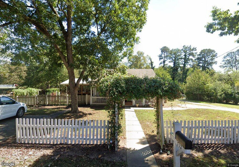
712 White St Suwanee, GA 30024
Estimated Value: $315,449 - $501,000
3
Beds
1
Bath
1,380
Sq Ft
$285/Sq Ft
Est. Value
About This Home
This home is located at 712 White St, Suwanee, GA 30024 and is currently estimated at $392,862, approximately $284 per square foot. 712 White St is a home located in Gwinnett County with nearby schools including Roberts Elementary School, North Gwinnett Middle School, and North Gwinnett High School.
Ownership History
Date
Name
Owned For
Owner Type
Purchase Details
Closed on
Jul 22, 2004
Sold by
Mashburn Willard O
Bought by
Mashburn Willard O and Mashburn Jill
Current Estimated Value
Home Financials for this Owner
Home Financials are based on the most recent Mortgage that was taken out on this home.
Original Mortgage
$112,500
Outstanding Balance
$58,173
Interest Rate
6.87%
Mortgage Type
New Conventional
Estimated Equity
$334,689
Purchase Details
Closed on
Apr 28, 2004
Sold by
Dcf Holdings Llc
Bought by
Mashburn Willard O
Purchase Details
Closed on
Mar 30, 2004
Sold by
Lance Ricky and Lance Teresa
Bought by
Dcf Holdings Llc
Create a Home Valuation Report for This Property
The Home Valuation Report is an in-depth analysis detailing your home's value as well as a comparison with similar homes in the area
Home Values in the Area
Average Home Value in this Area
Purchase History
| Date | Buyer | Sale Price | Title Company |
|---|---|---|---|
| Mashburn Willard O | -- | -- | |
| Mashburn Willard O | $71,000 | -- | |
| Dcf Holdings Llc | $60,000 | -- |
Source: Public Records
Mortgage History
| Date | Status | Borrower | Loan Amount |
|---|---|---|---|
| Open | Mashburn Willard O | $112,500 |
Source: Public Records
Tax History Compared to Growth
Tax History
| Year | Tax Paid | Tax Assessment Tax Assessment Total Assessment is a certain percentage of the fair market value that is determined by local assessors to be the total taxable value of land and additions on the property. | Land | Improvement |
|---|---|---|---|---|
| 2025 | $1,412 | $67,640 | $28,000 | $39,640 |
| 2024 | $1,513 | $67,640 | $28,000 | $39,640 |
| 2023 | $1,513 | $67,640 | $28,000 | $39,640 |
| 2022 | $1,488 | $49,920 | $15,600 | $34,320 |
| 2021 | $1,432 | $49,920 | $15,600 | $34,320 |
| 2020 | $1,445 | $49,920 | $15,600 | $34,320 |
| 2019 | $1,191 | $49,640 | $13,200 | $36,440 |
| 2018 | $1,198 | $49,640 | $13,200 | $36,440 |
| 2016 | $861 | $34,000 | $18,800 | $15,200 |
| 2015 | $869 | $34,000 | $18,800 | $15,200 |
| 2014 | $723 | $27,120 | $12,800 | $14,320 |
Source: Public Records
Map
Nearby Homes
- The Murray Plan at Old Town Suwanee
- The Telfair Plan at Old Town Suwanee
- 822 Urban Grange Way
- 3655 Belle Fields Crossing
- 3615 Belle Fields Crossing
- 3625 Belle Fields Crossing
- 3675 Belle Fields Crossing
- 3685 Belle Fields Crossing
- 3645 Belle Fields Crossing
- 3635 Belle Fields Crossing
- Burton Plan at Echo Park
- Sinclair Plan at Echo Park
- Flint Plan at Echo Park
- 911 Echo Park Dr
- 923 Echo Park Dr
- 825 Green Sapling Trail
- 825 Green Sapling Trail Unit 18
- 3854 Light Farms Way
- 3880 Brushy Creek Way
- 700 White St
- 732 White St
- 791 White St
- 671 Highway 23 NW
- 713 White St
- 691 Highway 23 NW
- 723 White St
- 693 White St
- 682 White St
- 721 Buford Hwy
- 721 Highway 23 NW
- 683 White St
- 721 Highway 23 NW
- 721 Hwy 23 NW
- 23 Highway NE
- 0 White Unit 7200502
- 0 White Unit 7266461
- 0 White Unit 8182421
- 0 White Unit 4336656
- 0 White Unit 4336257