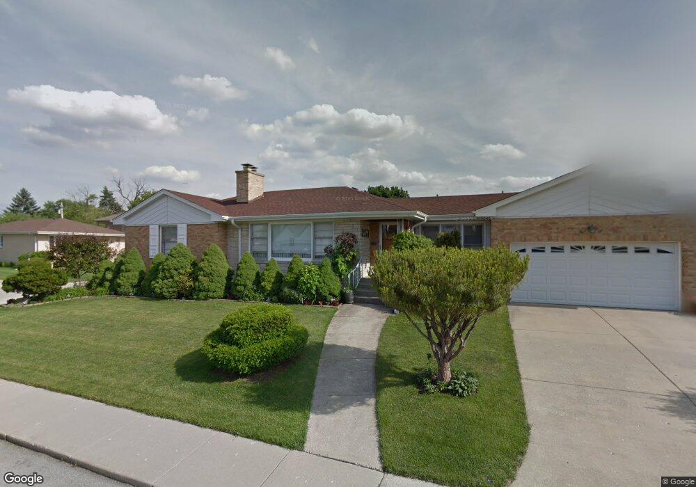
7135 W Seward St Niles, IL 60714
Evergreen Estates NeighborhoodEstimated Value: $407,000 - $474,000
2
Beds
1
Bath
1,238
Sq Ft
$351/Sq Ft
Est. Value
About This Home
This home is located at 7135 W Seward St, Niles, IL 60714 and is currently estimated at $434,147, approximately $350 per square foot. 7135 W Seward St is a home located in Cook County with nearby schools including Clarence E Culver School, Niles West High School, and St John Brebeuf School.
Ownership History
Date
Name
Owned For
Owner Type
Purchase Details
Closed on
Jan 12, 2004
Sold by
Dworakowski Stanley and Dworakowski Romana
Bought by
Dworakowski Stanley and Dworakowski Romana
Current Estimated Value
Purchase Details
Closed on
Nov 21, 1997
Sold by
Kawabata Flora
Bought by
Dworakowski Stanley and Dworakowski Romana
Purchase Details
Closed on
May 11, 1995
Sold by
Kawabata James and Kawabata Flora
Bought by
Kawabata Flora K and Flora K Kawabata Revocable Trust
Create a Home Valuation Report for This Property
The Home Valuation Report is an in-depth analysis detailing your home's value as well as a comparison with similar homes in the area
Home Values in the Area
Average Home Value in this Area
Purchase History
| Date | Buyer | Sale Price | Title Company |
|---|---|---|---|
| Dworakowski Stanley | -- | -- | |
| Dworakowski Stanley | $195,000 | -- | |
| Kawabata Flora K | -- | -- |
Source: Public Records
Tax History Compared to Growth
Tax History
| Year | Tax Paid | Tax Assessment Tax Assessment Total Assessment is a certain percentage of the fair market value that is determined by local assessors to be the total taxable value of land and additions on the property. | Land | Improvement |
|---|---|---|---|---|
| 2024 | $1,596 | $37,000 | $11,745 | $25,255 |
| 2023 | $1,543 | $37,000 | $11,745 | $25,255 |
| 2022 | $1,543 | $37,000 | $11,745 | $25,255 |
| 2021 | $1,710 | $27,267 | $8,265 | $19,002 |
| 2020 | $1,509 | $27,267 | $8,265 | $19,002 |
| 2019 | $1,502 | $30,297 | $8,265 | $22,032 |
| 2018 | $1,660 | $27,693 | $7,177 | $20,516 |
| 2017 | $1,669 | $27,693 | $7,177 | $20,516 |
| 2016 | $2,147 | $27,693 | $7,177 | $20,516 |
| 2015 | $2,402 | $24,982 | $6,090 | $18,892 |
| 2014 | $2,278 | $24,982 | $6,090 | $18,892 |
| 2013 | $2,296 | $24,982 | $6,090 | $18,892 |
Source: Public Records
Map
Nearby Homes
- 7232 W Oakton St
- 8206 N Octavia Ave
- 6964 W Cleveland St
- 6914 W Oakton Ct
- 8258 N Octavia Ave
- 8049 N Osceola Ave
- 8239 N New England Ave
- 7531 W Cleveland St
- 8341 N Osceola Ave
- 8311 N Olcott Ave
- 7753 N Nordica Ave
- 8037 N Oriole Ave
- 7448 W Jonquil Terrace
- 7554 N Waukegan Rd
- 7020 W Wright Terrace
- 8108 N Overhill Ave
- 8536 Grove St
- 6600 W Wood River Dr Unit B201B
- 7875 N Caldwell Ave Unit 302
- 7450 N Waukegan Rd Unit 206
- 7130 W Oakton Ct
- 7140 W Oakton Ct
- 7130 W Seward St
- 7146 W Oakton Ct
- 8033 N Nora Ave
- 7140 W Seward St
- 8037 N Nora Ave
- 8029 N Nora Ave
- 7153 W Seward St
- 7118 W Seward St
- 7150 W Oakton Ct
- 8025 N Nora Ave
- 7150 W Seward St
- 7112 W Seward St
- 7135 W Keeney St
- 7131 W Keeney St
- 7141 W Keeney St
- 7103 W Seward St
- 7125 W Keeney St