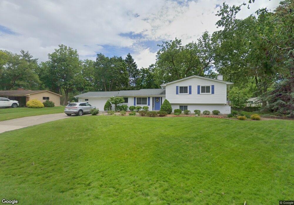
7143 Riverstone Rd West Bloomfield, MI 48322
Estimated Value: $363,022 - $449,000
3
Beds
3
Baths
2,008
Sq Ft
$199/Sq Ft
Est. Value
About This Home
This home is located at 7143 Riverstone Rd, West Bloomfield, MI 48322 and is currently estimated at $400,506, approximately $199 per square foot. 7143 Riverstone Rd is a home located in Oakland County with nearby schools including Wood Creek Elementary School, Warner Upper Elementary School, and Bloomfield Maples Montessori.
Ownership History
Date
Name
Owned For
Owner Type
Purchase Details
Closed on
Jan 27, 2025
Sold by
Elser Charles M and Elser Mary E
Bought by
Charles M Elser And Mary E Elser Joint Revoca and Elser
Current Estimated Value
Purchase Details
Closed on
Mar 24, 2000
Sold by
Titchenell Troy J
Bought by
Elser Charles M
Purchase Details
Closed on
Oct 16, 1998
Sold by
Haarala Jane M
Bought by
Titchenell Troy J
Home Financials for this Owner
Home Financials are based on the most recent Mortgage that was taken out on this home.
Original Mortgage
$149,600
Interest Rate
6.83%
Create a Home Valuation Report for This Property
The Home Valuation Report is an in-depth analysis detailing your home's value as well as a comparison with similar homes in the area
Home Values in the Area
Average Home Value in this Area
Purchase History
| Date | Buyer | Sale Price | Title Company |
|---|---|---|---|
| Charles M Elser And Mary E Elser Joint Revoca | -- | None Listed On Document | |
| Charles M Elser And Mary E Elser Joint Revoca | -- | None Listed On Document | |
| Elser Charles M | $209,000 | -- | |
| Titchenell Troy J | $187,000 | -- |
Source: Public Records
Mortgage History
| Date | Status | Borrower | Loan Amount |
|---|---|---|---|
| Previous Owner | Titchenell Troy J | $149,600 |
Source: Public Records
Tax History Compared to Growth
Tax History
| Year | Tax Paid | Tax Assessment Tax Assessment Total Assessment is a certain percentage of the fair market value that is determined by local assessors to be the total taxable value of land and additions on the property. | Land | Improvement |
|---|---|---|---|---|
| 2024 | $1,551 | $152,040 | $0 | $0 |
| 2022 | $1,494 | $147,470 | $47,500 | $99,970 |
| 2021 | $2,735 | $127,440 | $0 | $0 |
| 2020 | $1,429 | $120,510 | $39,310 | $81,200 |
| 2018 | $2,731 | $111,220 | $27,300 | $83,920 |
| 2015 | -- | $75,880 | $0 | $0 |
| 2014 | -- | $70,870 | $0 | $0 |
| 2011 | -- | $61,350 | $0 | $0 |
Source: Public Records
Map
Nearby Homes
- 7209 Stonebrook Rd
- 5312 Cambourne Place
- 7477 Gramercy Cir Unit 17
- 7479 Gramercy Cir Unit 16
- 7250 Ten Hill
- 7507 Gramercy Cir
- 7251 N Briarcliff Knoll Dr
- 29020 Ramblewood Dr
- 28786 Rockledge Dr
- 7431 N Briarcliff Knoll Dr
- 6545 Post Oak Dr
- 6564 Alderley Way
- 7023 Wild Ridge Ln
- 7335 Coach Ln
- 32411 Tareyton St
- 30070 Lochmoor St
- 32615 Briarcrest Knoll
- 2189 Colony Club Ct
- 30515 W 14 Mile Rd Unit 30
- 30515 W 14 Mile Rd Unit 37
- 7119 Riverstone Rd
- 7171 Riverstone Rd
- 7132 Valleybrook Rd
- 7158 Valleybrook Rd
- 7150 Riverstone Rd
- 7122 Riverstone Rd
- 7110 Valleybrook Rd
- 7180 Valleybrook Rd
- 7178 Riverstone Rd
- 7095 Riverstone Rd
- 7197 Riverstone Rd
- 7096 Riverstone Rd
- 7137 Stonebrook Rd
- 7090 Valleybrook Rd
- 7204 Valleybrook Rd
- 7163 Stonebrook Rd
- 7149 Valleybrook Rd
- 7121 Valleybrook Rd
- 7111 Stonebrook Rd
- 7173 Valleybrook Rd