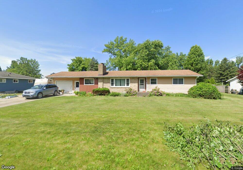
715 Cherokee Dr Fremont, MI 49412
Estimated Value: $258,396 - $299,000
3
Beds
3
Baths
1,569
Sq Ft
$177/Sq Ft
Est. Value
About This Home
This home is located at 715 Cherokee Dr, Fremont, MI 49412 and is currently estimated at $278,099, approximately $177 per square foot. 715 Cherokee Dr is a home located in Newaygo County with nearby schools including Daisy Brook Elementary School, Pathfinder Elementary School, and Quest High School.
Ownership History
Date
Name
Owned For
Owner Type
Purchase Details
Closed on
Mar 4, 2010
Sold by
Watters Judy L and Adair Ethel M
Bought by
Smith Doris J and Blondeel Debra J
Current Estimated Value
Home Financials for this Owner
Home Financials are based on the most recent Mortgage that was taken out on this home.
Original Mortgage
$98,188
Outstanding Balance
$65,174
Interest Rate
5.01%
Mortgage Type
FHA
Estimated Equity
$212,925
Purchase Details
Closed on
Apr 14, 2004
Sold by
Adair Ethel M
Bought by
Adair Ethel M and Watters Judy
Create a Home Valuation Report for This Property
The Home Valuation Report is an in-depth analysis detailing your home's value as well as a comparison with similar homes in the area
Home Values in the Area
Average Home Value in this Area
Purchase History
| Date | Buyer | Sale Price | Title Company |
|---|---|---|---|
| Smith Doris J | $102,000 | -- | |
| Adair Ethel M | -- | -- |
Source: Public Records
Mortgage History
| Date | Status | Borrower | Loan Amount |
|---|---|---|---|
| Open | Smith Doris J | $98,188 |
Source: Public Records
Tax History Compared to Growth
Tax History
| Year | Tax Paid | Tax Assessment Tax Assessment Total Assessment is a certain percentage of the fair market value that is determined by local assessors to be the total taxable value of land and additions on the property. | Land | Improvement |
|---|---|---|---|---|
| 2025 | $3,309 | $107,100 | $0 | $0 |
| 2024 | $25 | $97,600 | $0 | $0 |
| 2023 | $2,432 | $86,600 | $0 | $0 |
| 2022 | $3,047 | $73,900 | $0 | $0 |
| 2021 | $2,946 | $72,300 | $0 | $0 |
| 2020 | $2,910 | $69,800 | $0 | $0 |
| 2019 | $2,787 | $61,100 | $0 | $0 |
| 2018 | $2,722 | $59,100 | $0 | $0 |
| 2017 | $2,683 | $59,400 | $0 | $0 |
| 2016 | $2,477 | $59,700 | $0 | $0 |
| 2015 | -- | $58,900 | $0 | $0 |
| 2014 | -- | $57,100 | $0 | $0 |
Source: Public Records
Map
Nearby Homes
- 421 Cherokee Dr
- 521 E Pine St
- 347 E Pine St
- 601 E Oak St
- 130 Southwoods Ave
- 5296 S Warner Ave
- 343 E Maple St
- 109 E Pine St
- 318 E Dayton St
- 320 S Division Ave
- 17 E Oak St
- 116 E Sheridan St
- 121 N Decker Ave
- 333 E Elm St
- 340 E Cherry St
- 109 W Woodrow St
- 306 Meister Rd
- 203 Baden Place
- 518 S Sullivan Ave
- 501 S Sullivan Ave
- 725 Cherokee Dr
- 703 Cherokee Dr
- 703 Cherokee Dr Unit 19 &
- 714 Cherokee Dr
- 532 Seminole Dr
- 509 Apache Dr
- 728 Cherokee Dr
- 546 Seminole Dr
- 520 Apache Dr
- 510 Apache Dr
- 455 Apache Dr
- 506 Apache Dr
- 531 Seminole Dr
- 613 Cherokee Dr
- 601 Apache Dr
- 600 Seminole Dr
- 604 Cherokee Dr
- 543 Seminole Dr
- 221 Apache Dr
- 0 Apache Dr