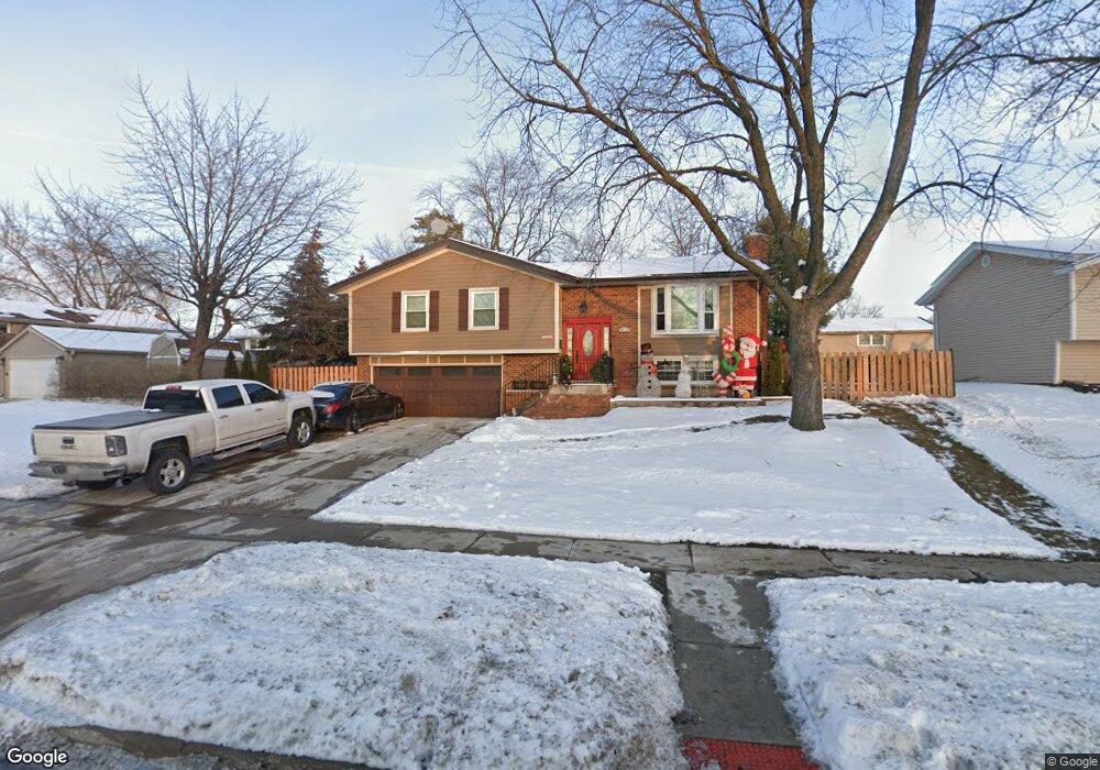
715 S Cedarcrest Dr Schaumburg, IL 60193
South Schaumburg NeighborhoodEstimated Value: $452,673 - $505,000
4
Beds
3
Baths
1,470
Sq Ft
$324/Sq Ft
Est. Value
About This Home
This home is located at 715 S Cedarcrest Dr, Schaumburg, IL 60193 and is currently estimated at $476,918, approximately $324 per square foot. 715 S Cedarcrest Dr is a home located in Cook County with nearby schools including Edwin Aldrin Elementary School, Robert Frost Junior High School, and Schaumburg High School.
Ownership History
Date
Name
Owned For
Owner Type
Purchase Details
Closed on
Jul 7, 2023
Sold by
Jamiolkowski Ewelina and Jamiolkowski Mariusz
Bought by
Jamiolkowski Ewelina
Current Estimated Value
Purchase Details
Closed on
Mar 17, 2017
Sold by
Cimbalo George U and Cimbalo Sari E
Bought by
Jamiolkowski Mariusz and Jamiolkowski Ewelina
Home Financials for this Owner
Home Financials are based on the most recent Mortgage that was taken out on this home.
Original Mortgage
$237,000
Interest Rate
4.5%
Mortgage Type
New Conventional
Create a Home Valuation Report for This Property
The Home Valuation Report is an in-depth analysis detailing your home's value as well as a comparison with similar homes in the area
Home Values in the Area
Average Home Value in this Area
Purchase History
| Date | Buyer | Sale Price | Title Company |
|---|---|---|---|
| Jamiolkowski Ewelina | -- | None Listed On Document | |
| Jamiolkowski Mariusz | $297,000 | Chicago Title Insurance Co |
Source: Public Records
Mortgage History
| Date | Status | Borrower | Loan Amount |
|---|---|---|---|
| Previous Owner | Jamiolkowski Mariusz | $237,000 |
Source: Public Records
Tax History Compared to Growth
Tax History
| Year | Tax Paid | Tax Assessment Tax Assessment Total Assessment is a certain percentage of the fair market value that is determined by local assessors to be the total taxable value of land and additions on the property. | Land | Improvement |
|---|---|---|---|---|
| 2024 | $8,035 | $32,000 | $6,230 | $25,770 |
| 2023 | $7,763 | $32,000 | $6,230 | $25,770 |
| 2022 | $7,763 | $32,000 | $6,230 | $25,770 |
| 2021 | $6,268 | $24,011 | $4,227 | $19,784 |
| 2020 | $6,228 | $24,011 | $4,227 | $19,784 |
| 2019 | $6,312 | $26,979 | $4,227 | $22,752 |
| 2018 | $5,327 | $21,187 | $3,782 | $17,405 |
| 2017 | $7,594 | $25,709 | $3,782 | $21,927 |
| 2016 | $5,919 | $25,709 | $3,782 | $21,927 |
| 2015 | $5,344 | $22,414 | $3,337 | $19,077 |
| 2014 | $5,175 | $22,414 | $3,337 | $19,077 |
| 2013 | $5,162 | $22,414 | $3,337 | $19,077 |
Source: Public Records
Map
Nearby Homes
- 712 Dante Ct
- 516 W Weathersfield Way
- 415 Laconia Ln
- 635 Limerick Ln Unit 2B
- 315 Ashwood Dr
- 412 Redwood Ln
- 631 Derry Ct Unit 3C
- 614 Tralee Ct Unit 2-C
- 733 Limerick Ln Unit 7333D
- 711 Tipperary Ct Unit 2D
- 1109 Beach Comber Dr
- 818 Brentwood Ct
- 226 Timbercrest Dr
- 988 Chelsea Ln
- 36 Shore Dr
- 220 Kemah Ln
- 357 Lucille Ln Unit 30
- 305 Williams Dr
- 1008 Shannock Ln
- 1027 Duxbury Ln
- 721 S Cedarcrest Dr
- 431 Chopin Ct
- 427 Chopin Ct
- 424 Desmond Dr
- 423 Chopin Ct
- 718 S Cedarcrest Dr
- 420 Desmond Dr
- 502 Boxwood Dr Unit 923
- 419 Chopin Ct
- 724 S Cedarcrest Dr
- 706 S Cedarcrest Dr
- 429 Desmond Dr
- 416 Desmond Dr
- 635 S Cedarcrest Dr
- 425 Desmond Dr
- 719 Keats Ct
- 700 S Cedarcrest Dr
- 415 Chopin Ct
- 730 S Cedarcrest Dr
- 508 Boxwood Dr