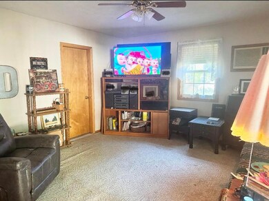
7152 State Highway O Udall, MO 65766
Estimated payment $922/month
Highlights
- No HOA
- 1-Story Property
- 6 Garage Spaces | 1 Attached and 5 Detached
- Window Unit Cooling System
- Forced Air Heating System
- Wood Burning Fireplace
About This Home
Motivated Seller! Charming 3-bedroom, 1-bath home with 1,860 sq ft on just under an acre, only 1.5 miles from Norfork Lake. The property includes a wood-burning fireplace, partial basement, and an attached garage that has already been plumbed and wired for a future kitchenette and bathroom — making it possible to convert into a guest suite, rental, or private quarters. In addition to the main home, there are three detached buildings offering exceptional flexibility: Main shop with concrete floor, electricity, wood-burning stove, and a lean-to for extra covered storage. Second shop with concrete floor, electricity, lean-to, and set up for a future wood stove. Pontoon shed, designed specifically for storing a pontoon boat. One of the shops also includes a separate back entrance and a partially finished interior with a bathroom and small studio-style layout, giving even more options for hobbies, guest lodging, or rental potential. With plenty of space for boats, RVs, and vehicles, plus the flexibility to expand living areas, this property is ideal as a year-round residence, lake retreat, or investment opportunity. Located close to Udall Park and boat ramps, it's the perfect base for fishing, boating, and enjoying Norfork Lake.
Home Details
Home Type
- Single Family
Est. Annual Taxes
- $597
Year Built
- Built in 1950
Lot Details
- 0.9 Acre Lot
- Property fronts a state road
Parking
- 6 Garage Spaces | 1 Attached and 5 Detached
Interior Spaces
- 2,252 Sq Ft Home
- 1-Story Property
- Wood Burning Fireplace
- Partially Finished Basement
- Partial Basement
Bedrooms and Bathrooms
- 3 Bedrooms
- 1 Full Bathroom
Schools
- Bakersfield Elementary School
- Bakersfield High School
Utilities
- Window Unit Cooling System
- Forced Air Heating System
- Heating System Uses Propane
- Heating System Uses Wood
- Private Company Owned Well
- Septic Tank
Community Details
- No Home Owners Association
Listing and Financial Details
- Tax Lot 35
- Assessor Parcel Number 140735000000003000
Map
Home Values in the Area
Average Home Value in this Area
Tax History
| Year | Tax Paid | Tax Assessment Tax Assessment Total Assessment is a certain percentage of the fair market value that is determined by local assessors to be the total taxable value of land and additions on the property. | Land | Improvement |
|---|---|---|---|---|
| 2025 | $597 | $12,070 | $0 | $0 |
| 2024 | $597 | $10,790 | $0 | $0 |
| 2023 | $594 | $10,790 | $0 | $0 |
| 2022 | $506 | $9,220 | $0 | $0 |
| 2021 | $525 | $9,220 | $0 | $0 |
| 2020 | $525 | $9,920 | $0 | $0 |
| 2019 | $532 | $9,920 | $0 | $0 |
| 2018 | $522 | $9,920 | $0 | $0 |
| 2017 | $508 | $9,920 | $0 | $0 |
| 2016 | $452 | $8,890 | $0 | $0 |
| 2015 | -- | $8,890 | $0 | $0 |
| 2013 | -- | $8,890 | $0 | $0 |
Property History
| Date | Event | Price | List to Sale | Price per Sq Ft |
|---|---|---|---|---|
| 10/24/2025 10/24/25 | Price Changed | $165,000 | -2.9% | $73 / Sq Ft |
| 10/24/2025 10/24/25 | Price Changed | $170,000 | -5.6% | $75 / Sq Ft |
| 10/02/2025 10/02/25 | For Sale | $180,000 | -- | $80 / Sq Ft |
Purchase History
| Date | Type | Sale Price | Title Company |
|---|---|---|---|
| Warranty Deed | -- | None Listed On Document | |
| Warranty Deed | -- | None Listed On Document | |
| Warranty Deed | $191,520 | Mct Title Services |
Mortgage History
| Date | Status | Loan Amount | Loan Type |
|---|---|---|---|
| Previous Owner | $144,000 | New Conventional |
Source: Southern Missouri Regional MLS
MLS Number: 60306235
APN: 14-0.7-35-000-000-003.000
- Tdb State Highway O
- 8557 State Highway O
- 1201 County Road 555b
- Lot 28 County Road 555 C
- 0 County Road 553
- 000 County Road 544
- 112 Corbin Valley
- 1246 State Hwy Ee
- 1246 State Highway Ee
- 0 County Road 544 Unit MAR25018845
- Tbd County Road 553 A
- 000 Cr 543
- 000 Hwy 160
- 88 Chestnut Ln
- 13-0.4-20-000-0 Cr 544
- 002-11058-011 County Road 23
- Tbd County Road 557
- 77 Gaddy Ln
- 77 Gaddy Ln
- 113 Norford Ln


