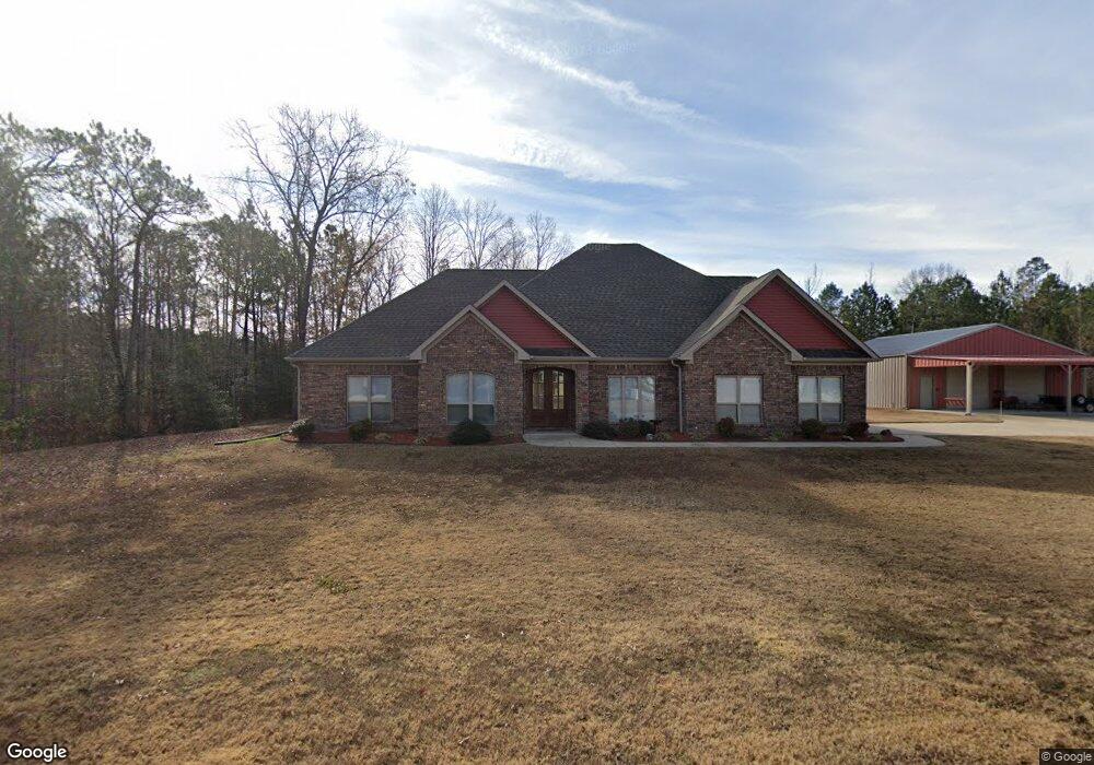
7153 Rolling Meadow Loop Benton, AR 72015
Estimated Value: $322,000 - $504,016
Studio
1
Bath
2,510
Sq Ft
$174/Sq Ft
Est. Value
About This Home
This home is located at 7153 Rolling Meadow Loop, Benton, AR 72015 and is currently estimated at $436,254, approximately $173 per square foot. 7153 Rolling Meadow Loop is a home with nearby schools including Westbrook Elementary School, Harmony Grove Middle School, and Harmony Grove High School.
Ownership History
Date
Name
Owned For
Owner Type
Purchase Details
Closed on
Feb 8, 2021
Sold by
Jordan Robert J and Jordan Donna R
Bought by
Jordan Family Revocable Trust and Jordan
Current Estimated Value
Purchase Details
Closed on
May 24, 2016
Sold by
Penet Enterprises Llc
Bought by
Jordan Robert J and Jordan Donna R
Purchase Details
Closed on
Oct 29, 2015
Bought by
Penet Const
Purchase Details
Closed on
Oct 27, 2015
Bought by
Penet Const
Create a Home Valuation Report for This Property
The Home Valuation Report is an in-depth analysis detailing your home's value as well as a comparison with similar homes in the area
Home Values in the Area
Average Home Value in this Area
Purchase History
| Date | Buyer | Sale Price | Title Company |
|---|---|---|---|
| Jordan Family Revocable Trust | -- | None Listed On Document | |
| Jordan Family Revocable Trust | -- | None Listed On Document | |
| Jordan Robert J | $282,500 | Saline Abstract & Title Co | |
| Penet Const | $33,000 | -- | |
| Penet Const | $33,000 | -- |
Source: Public Records
Tax History
| Year | Tax Paid | Tax Assessment Tax Assessment Total Assessment is a certain percentage of the fair market value that is determined by local assessors to be the total taxable value of land and additions on the property. | Land | Improvement |
|---|---|---|---|---|
| 2025 | $2,874 | $79,955 | $14,225 | $65,730 |
| 2024 | $2,874 | $79,955 | $14,225 | $65,730 |
| 2023 | $4,254 | $79,955 | $14,225 | $65,730 |
| 2022 | $4,304 | $79,955 | $14,225 | $65,730 |
| 2021 | $4,304 | $60,000 | $10,160 | $49,840 |
| 2020 | $4,259 | $60,000 | $10,160 | $49,840 |
| 2019 | $4,259 | $60,000 | $10,160 | $49,840 |
| 2018 | $4,284 | $60,000 | $10,160 | $49,840 |
| 2017 | $4,173 | $58,730 | $10,160 | $48,570 |
| 2016 | $224 | $4,680 | $4,680 | $0 |
| 2015 | $1,364 | $4,680 | $4,680 | $0 |
| 2014 | $1,364 | $4,680 | $4,680 | $0 |
Source: Public Records
Map
Nearby Homes
- 4133 Brody Crossing
- 0 Oklahoma Inn Rd Unit 24728946
- 0 Oklahoma Inn Rd Unit 24728947
- 0000 Deer Creek Rd
- 2009 Berkshire Dr
- 4093 Hampton Dr
- 7801 Holy Ridge Cutoff
- 109 Riveria Cove
- 10664 Gunter Loop
- 8617 Pawnee Dr
- 5017 Rolling Meadow Loop
- 5086 Oklahoma Inn Rd
- 7121 Rolling Meadow Loop
- 105 Kapalua Cove
- 810 Troutman Rd
- 815 Graham Rd
- 107 Sawgrass Dr
- Exit 114 Interstate 30 Service Rd
- 31 W Elm Haskell St
- 123 Harmony Village Dr
- 9000 Hokes Path
- 9001 Hokes Path
- 8886 Highway 67
- 9024 Highway 67
- 9420 Hokes Path
- 8842 Highway 67
- 8812 Smith Loop
- 9312 Mangum Rd
- 8964 Highway 67
- 8460 Highway 67
- 9038 U S 67
- 9002 Highway 67
- 9038 Highway 67
- 9301 Mangum Rd
- 8460 Highway 67
- 0 Hwy 67 Unit 15031940
- 0 Hwy 67 Unit 20026571
- 0 Hwy 67 Unit 20006145
- 8460 Hwy 67
- 9601 Hokes Path
Your Personal Tour Guide
Ask me questions while you tour the home.