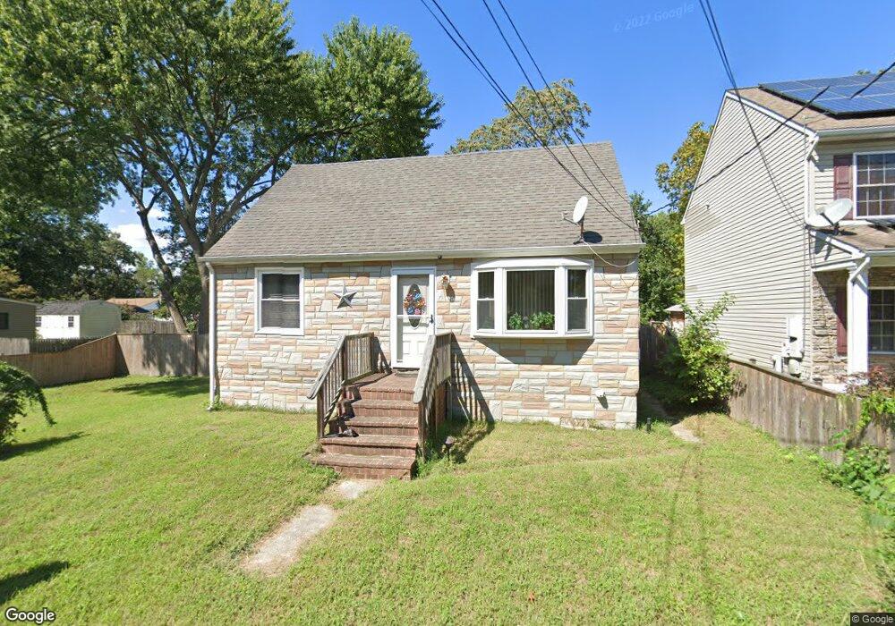
716 207th St Pasadena, MD 21122
Green Haven NeighborhoodEstimated Value: $274,000 - $358,000
Studio
1
Bath
1,080
Sq Ft
$290/Sq Ft
Est. Value
About This Home
This home is located at 716 207th St, Pasadena, MD 21122 and is currently estimated at $313,058, approximately $289 per square foot. 716 207th St is a home located in Anne Arundel County with nearby schools including High Point Elementary School, Northeast Middle School, and Northeast High School.
Ownership History
Date
Name
Owned For
Owner Type
Purchase Details
Closed on
Sep 8, 2008
Sold by
Thomas Frank A
Bought by
Thomas Fran
Current Estimated Value
Home Financials for this Owner
Home Financials are based on the most recent Mortgage that was taken out on this home.
Original Mortgage
$200,000
Outstanding Balance
$122,636
Interest Rate
6.8%
Mortgage Type
New Conventional
Estimated Equity
$190,422
Purchase Details
Closed on
Jul 27, 2006
Sold by
Thomas Frank A
Bought by
Thomas Fran
Home Financials for this Owner
Home Financials are based on the most recent Mortgage that was taken out on this home.
Original Mortgage
$200,000
Interest Rate
6.8%
Mortgage Type
New Conventional
Purchase Details
Closed on
May 25, 1999
Sold by
Grantland Helen F
Bought by
Thomas Frank A
Create a Home Valuation Report for This Property
The Home Valuation Report is an in-depth analysis detailing your home's value as well as a comparison with similar homes in the area
Home Values in the Area
Average Home Value in this Area
Purchase History
| Date | Buyer | Sale Price | Title Company |
|---|---|---|---|
| Thomas Fran | -- | -- | |
| Thomas Fran | -- | -- | |
| Thomas Frank A | $104,600 | -- |
Source: Public Records
Mortgage History
| Date | Status | Borrower | Loan Amount |
|---|---|---|---|
| Open | Thomas Fran | $200,000 | |
| Previous Owner | Thomas Fran | $200,000 | |
| Closed | Thomas Frank A | -- |
Source: Public Records
Tax History
| Year | Tax Paid | Tax Assessment Tax Assessment Total Assessment is a certain percentage of the fair market value that is determined by local assessors to be the total taxable value of land and additions on the property. | Land | Improvement |
|---|---|---|---|---|
| 2025 | $2,172 | $251,833 | -- | -- |
| 2024 | $2,172 | $237,200 | $146,100 | $91,100 |
| 2023 | $2,101 | $227,800 | $0 | $0 |
| 2022 | $2,282 | $218,400 | $0 | $0 |
| 2020 | $1,848 | $203,900 | $0 | $0 |
| 2019 | $3,570 | $198,800 | $0 | $0 |
| 2018 | $200 | $193,700 | $116,100 | $77,600 |
| 2017 | $1,689 | $181,700 | $0 | $0 |
| 2016 | $200 | $169,700 | $0 | $0 |
| 2015 | $200 | $157,700 | $0 | $0 |
| 2014 | -- | $157,700 | $0 | $0 |
Source: Public Records
Map
Nearby Homes
- 717 207th St
- 762 208th St
- 753 210th St
- 7832 E Shore Rd
- 7804 A E Shore Rd
- 808 207th St
- 7803 W Shore Rd
- 809 203rd St
- 811 203rd St
- 7850 B E Shore Rd
- 667 213th St
- 813 201st St
- 7758 Lyman Ave
- 7759 Glen Ave
- 365 Hickory Nut Ct
- 7707 Lake Cir
- 7720 W Shore Rd
- 787 Powhatan Beach Rd
- 941 8th St
- 8146 Hazy Dawn Ct
Your Personal Tour Guide
Ask me questions while you tour the home.