Estimated Value: $129,000 - $154,000
3
Beds
--
Bath
1,818
Sq Ft
$79/Sq Ft
Est. Value
About This Home
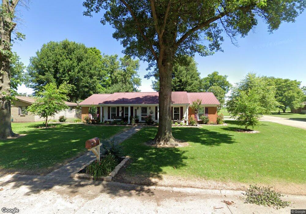
This home is located at 716 E Patricia Dr, Hayti, MO 63851 and is currently estimated at $143,914, approximately $79 per square foot. 716 E Patricia Dr is a home with nearby schools including Mathis Elementary School, Wallace Elementary School, and Hayti High School.
Ownership History
Date
Name
Owned For
Owner Type
Purchase Details
Closed on
Feb 22, 2023
Sold by
Bush Bobby and Bush Linda
Bought by
Bush Bobby
Current Estimated Value
Purchase Details
Closed on
Jul 6, 2018
Sold by
Pekas Mario and Pekas Julia
Bought by
Bush Bobby and Bush Linda
Home Financials for this Owner
Home Financials are based on the most recent Mortgage that was taken out on this home.
Original Mortgage
$122,580
Interest Rate
4.5%
Mortgage Type
VA
Purchase Details
Closed on
Aug 21, 2015
Sold by
Kingston Patrick B and Kingston Kimberly A
Bought by
Pekas Mario and Pekas Julia
Home Financials for this Owner
Home Financials are based on the most recent Mortgage that was taken out on this home.
Original Mortgage
$120,000
Interest Rate
4.12%
Mortgage Type
New Conventional
Create a Home Valuation Report for This Property
The Home Valuation Report is an in-depth analysis detailing your home's value as well as a comparison with similar homes in the area
Purchase History
| Date | Buyer | Sale Price | Title Company |
|---|---|---|---|
| Bush Bobby | -- | None Listed On Document | |
| Bush Bobby | $120,000 | None Available | |
| Pekas Mario | -- | Fs Title |
Source: Public Records
Mortgage History
| Date | Status | Borrower | Loan Amount |
|---|---|---|---|
| Previous Owner | Bush Bobby | $122,580 | |
| Previous Owner | Pekas Mario | $120,000 |
Source: Public Records
Tax History
| Year | Tax Paid | Tax Assessment Tax Assessment Total Assessment is a certain percentage of the fair market value that is determined by local assessors to be the total taxable value of land and additions on the property. | Land | Improvement |
|---|---|---|---|---|
| 2025 | $968 | $16,980 | $0 | $0 |
| 2024 | $968 | $16,360 | $0 | $0 |
| 2023 | $950 | $16,360 | $0 | $0 |
| 2022 | $903 | $15,610 | $0 | $0 |
| 2020 | $889 | $15,470 | $0 | $0 |
| 2019 | $877 | $15,470 | $0 | $0 |
| 2018 | $807 | $14,770 | $0 | $0 |
| 2017 | $807 | $14,770 | $0 | $0 |
| 2016 | -- | $14,670 | $0 | $0 |
| 2015 | -- | $14,670 | $0 | $0 |
| 2013 | -- | $14,680 | $0 | $0 |
Source: Public Records
Map
Nearby Homes
- 600 E Reed St
- 604 N 3rd St
- 301 E Jackson St
- 000000 First Martin Luther King Dr
- 200 E Grant St
- 110 E Main St
- 0 W Washington St
- 203 E Plum St
- 1014 S Klinkhardt St
- 0 Highway 412
- 0 County Road 263 Unit MIS25048822
- 0 County Road 406
- 835 Missouri 84
- 1110 Collins Ave
- 802 Beckwith Ave
- 939 Grand Ave
- 406 W 4th St
- 407 W 8th St
- 1202 Grand Ave
- 700 Carleton Ave
- 714 E Patricia Dr
- 709 E Cleveland St
- 714 N Gayoso St
- 712 N Gayoso St
- 712 E Patricia Dr
- 709 N Gayoso St
- 711 E Patricia Dr
- 701 E Cleveland St
- 710 N Gayoso St
- 716 N Gayoso St
- 710 E Patricia Dr
- 705 E Cleveland St
- 709 E Patricia Dr
- 708 E Patricia Dr
- 714 E Cleveland St
- 705 Kristina Reed St
- 614 E Missouri Ave
- 707 E Patricia Dr
- 708 N Gayoso St
- 707 N Goodland St
Your Personal Tour Guide
Ask me questions while you tour the home.