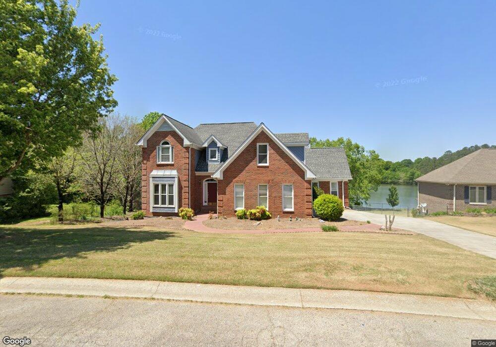
716 Mallard Dr Unit 1 Winder, GA 30680
Estimated Value: $383,603 - $422,000
Studio
3
Baths
2,757
Sq Ft
$144/Sq Ft
Est. Value
About This Home
This home is located at 716 Mallard Dr Unit 1, Winder, GA 30680 and is currently estimated at $397,651, approximately $144 per square foot. 716 Mallard Dr Unit 1 is a home located in Barrow County with nearby schools including County Line Elementary School, Russell Middle School, and Winder-Barrow High School.
Ownership History
Date
Name
Owned For
Owner Type
Purchase Details
Closed on
Apr 29, 2020
Sold by
Dube Joseph A Estate
Bought by
Padrick Bobby L and Padrick Patricia Wright
Current Estimated Value
Purchase Details
Closed on
Apr 17, 1996
Sold by
Peoples Bk
Bought by
Dube Joseph Lois
Purchase Details
Closed on
Feb 9, 1996
Sold by
Vanderford Charles M
Bought by
The Peoples Bank
Create a Home Valuation Report for This Property
The Home Valuation Report is an in-depth analysis detailing your home's value as well as a comparison with similar homes in the area
Home Values in the Area
Average Home Value in this Area
Purchase History
We collect this data history from publicly available records. To have your information removed, we recommend requesting removal directly through your county’s website.
| Date | Buyer | Sale Price | Title Company |
|---|---|---|---|
| Padrick Bobby L | -- | -- | |
| Dube Joseph Lois | $195,000 | -- | |
| The Peoples Bank | $180,000 | -- |
Source: Public Records
Mortgage History
We collect this data history from publicly available records. To have your information removed, we recommend requesting removal directly through your county’s website.
| Date | Status | Borrower | Loan Amount |
|---|---|---|---|
| Closed | Dube Joseph Lois | $0 |
Source: Public Records
Tax History
| Year | Tax Paid | Tax Assessment Tax Assessment Total Assessment is a certain percentage of the fair market value that is determined by local assessors to be the total taxable value of land and additions on the property. | Land | Improvement |
|---|---|---|---|---|
| 2025 | $1,677 | $143,161 | $28,000 | $115,161 |
| 2024 | $3,943 | $139,973 | $28,000 | $111,973 |
| 2023 | $4,620 | $139,973 | $28,000 | $111,973 |
| 2022 | $3,328 | $98,344 | $16,400 | $81,944 |
| 2021 | $3,535 | $98,344 | $16,400 | $81,944 |
| 2020 | $2,985 | $91,549 | $16,400 | $75,149 |
| 2019 | $3,026 | $91,549 | $16,400 | $75,149 |
| 2018 | $2,867 | $86,518 | $15,200 | $71,318 |
| 2017 | $2,369 | $79,404 | $15,200 | $64,204 |
| 2016 | $2,441 | $76,991 | $15,200 | $61,791 |
| 2015 | $2,470 | $77,768 | $15,200 | $62,568 |
| 2014 | $2,202 | $70,205 | $6,860 | $63,345 |
| 2013 | -- | $67,039 | $6,860 | $60,179 |
Source: Public Records
Map
Nearby Homes
- 719 Mallard Dr
- 621 Teal Dr
- 460 Flyway Ln
- 0 Hal Jackson Rd Unit 23011875
- 281 Natchez Cir
- 385 Cedar Wood Trace
- 367 Cedar Wood Trace
- 355 Cedar Wood Trace
- 374 Cedar Wood Trace
- 362 Cedar Wood Trace
- 341 Cedar Wood Trace
- 469 Plantation Dr
- 314 Cedar Wood Trace
- 846 Idlewood Rd
- 264 Cedar Wood Trace
- 858 Pine Shadow Ln
- 0 E Northcrest Dr Unit 10648147
- 74 Shoal Ct
- 76 Shoal Ct
- 244 Natchez Cir
- 714 Mallard Dr
- 712 Mallard Dr
- 715 Mallard Dr Unit 13B
- 715 Mallard Dr Unit 1
- 718 Mallard Dr Unit 31
- 718 Mallard Dr Unit 1
- 715 Overlook Dr Unit 2
- 710 Mallard Dr
- 710 Mallard Dr Unit 1
- 717 Mallard Dr Unit 1
- 717 Mallard Dr
- 711 Mallard Dr
- 717 Overlook Dr Unit 2
- 720 Mallard Dr
- 719 Mallard Dr Unit 15
- 702 High Point Dr Unit 1
- 704 High Point Dr
- 719 Overlook Dr
- 719 Overlook Dr Unit 2
- 721 Mallard Dr
Your Personal Tour Guide
Ask me questions while you tour the home.