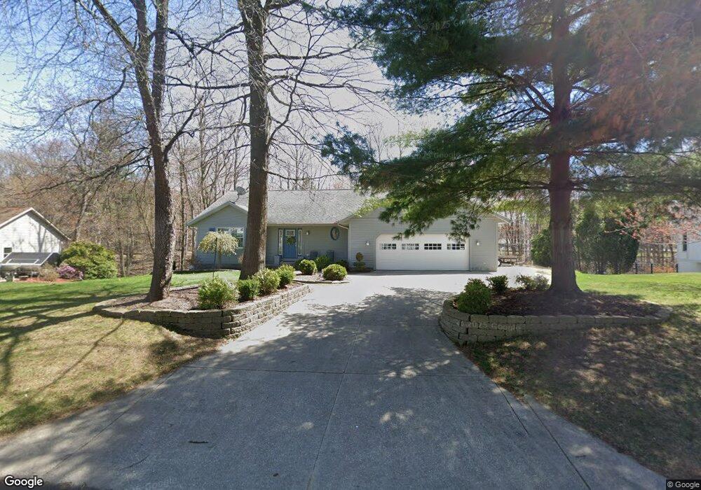
717 Brook Ridge Dr Norton Shores, MI 49441
Estimated Value: $347,000 - $430,000
3
Beds
3
Baths
2,308
Sq Ft
$172/Sq Ft
Est. Value
About This Home
This home is located at 717 Brook Ridge Dr, Norton Shores, MI 49441 and is currently estimated at $396,797, approximately $171 per square foot. 717 Brook Ridge Dr is a home located in Muskegon County with nearby schools including Mona Shores High School, Michigan Dunes Montessori School, and West Shore Lutheran School.
Ownership History
Date
Name
Owned For
Owner Type
Purchase Details
Closed on
May 5, 2006
Sold by
Winicki Gerald J and Winicki Sue
Bought by
Pothoff Gary L and Pothoff Kristi
Current Estimated Value
Home Financials for this Owner
Home Financials are based on the most recent Mortgage that was taken out on this home.
Original Mortgage
$155,900
Outstanding Balance
$90,239
Interest Rate
6.39%
Mortgage Type
Fannie Mae Freddie Mac
Estimated Equity
$306,558
Purchase Details
Closed on
Nov 30, 2004
Sold by
Winicki Victoria L and Winicki Victoria
Bought by
Winicki Gerald J
Home Financials for this Owner
Home Financials are based on the most recent Mortgage that was taken out on this home.
Original Mortgage
$144,650
Interest Rate
5.82%
Mortgage Type
New Conventional
Create a Home Valuation Report for This Property
The Home Valuation Report is an in-depth analysis detailing your home's value as well as a comparison with similar homes in the area
Home Values in the Area
Average Home Value in this Area
Purchase History
| Date | Buyer | Sale Price | Title Company |
|---|---|---|---|
| Pothoff Gary L | $194,900 | Lighthouse Title Inc | |
| Winicki Gerald J | -- | Harbor Title |
Source: Public Records
Mortgage History
| Date | Status | Borrower | Loan Amount |
|---|---|---|---|
| Open | Pothoff Gary L | $155,900 | |
| Previous Owner | Winicki Gerald J | $144,650 |
Source: Public Records
Tax History Compared to Growth
Tax History
| Year | Tax Paid | Tax Assessment Tax Assessment Total Assessment is a certain percentage of the fair market value that is determined by local assessors to be the total taxable value of land and additions on the property. | Land | Improvement |
|---|---|---|---|---|
| 2025 | $4,117 | $205,700 | $0 | $0 |
| 2024 | $3,227 | $192,100 | $0 | $0 |
| 2023 | $3,082 | $166,000 | $0 | $0 |
| 2022 | $3,616 | $146,100 | $0 | $0 |
| 2021 | $3,514 | $132,900 | $0 | $0 |
| 2020 | $3,474 | $124,200 | $0 | $0 |
| 2019 | $3,410 | $111,200 | $0 | $0 |
| 2018 | $3,330 | $100,900 | $0 | $0 |
| 2017 | $3,253 | $97,100 | $0 | $0 |
| 2016 | $2,519 | $93,100 | $0 | $0 |
| 2015 | -- | $89,600 | $0 | $0 |
| 2014 | $3,023 | $84,400 | $0 | $0 |
| 2013 | -- | $78,700 | $0 | $0 |
Source: Public Records
Map
Nearby Homes
- 516 Hendrick Rd
- 5128 Henry St
- 608 Porter Rd
- 4655 Henry St
- 4666 Heinicke St
- 263 Churchill Dr
- 5153 Shady Creek Dr
- 4676 Earl St
- 5085 Gay St
- 243 Lake Dr
- 740 Bridgeview Bay Dr
- 5473 Martin Rd
- 5579 Martin Rd
- 1558 Brookwood Dr
- 5075 Wickham Dr
- 1087 W Mount Garfield Rd
- 1103 W Mount Garfield Rd
- 1769 Bayview Dr
- 4230 Braeburn Ct
- 4235 Braeburn Ct
- 705 Brook Ridge Dr
- 720 Brookridge Dr
- 725 Brookridge Dr
- 700 Brook Ridge Dr
- 679 Brook Ridge Dr
- 730 Brookridge Dr
- 750 Brook Ridge Dr
- 686 Hendrick Rd
- 750 Brook Ridge Dr
- 755 Brook Ridge Dr
- 720 Hendrick Rd
- 755 Churchill Dr
- 750 Hendrick Rd
- 671 Brook Ridge Dr
- 775 Churchill Dr
- 734 Hendrick Rd
- 706 Hendrick Rd
- 664 Hendrick Rd
- 781 Churchill Dr
- 785 Churchill Dr