Estimated Value: $229,000 - $259,000
3
Beds
1
Bath
1,147
Sq Ft
$213/Sq Ft
Est. Value
About This Home
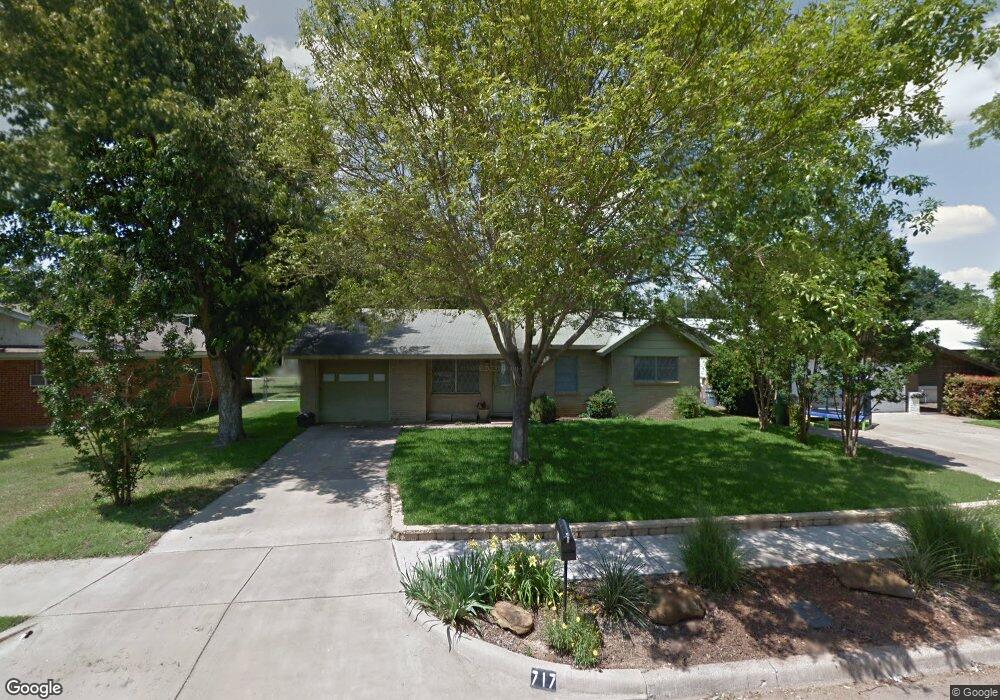
This home is located at 717 Brookfield Dr, Hurst, TX 76053 and is currently estimated at $244,307, approximately $212 per square foot. 717 Brookfield Dr is a home located in Tarrant County with nearby schools including Bellaire Elementary School, Hurst J High School, and L.D. Bell High School.
Ownership History
Date
Name
Owned For
Owner Type
Purchase Details
Closed on
Jan 9, 2002
Sold by
Addington William H
Bought by
Twietheyer Ron W
Current Estimated Value
Home Financials for this Owner
Home Financials are based on the most recent Mortgage that was taken out on this home.
Original Mortgage
$60,500
Outstanding Balance
$24,706
Interest Rate
7.03%
Estimated Equity
$219,601
Create a Home Valuation Report for This Property
The Home Valuation Report is an in-depth analysis detailing your home's value as well as a comparison with similar homes in the area
Home Values in the Area
Average Home Value in this Area
Purchase History
| Date | Buyer | Sale Price | Title Company |
|---|---|---|---|
| Twietheyer Ron W | -- | Metroplex Title Inc |
Source: Public Records
Mortgage History
| Date | Status | Borrower | Loan Amount |
|---|---|---|---|
| Open | Twietheyer Ron W | $60,500 |
Source: Public Records
Tax History Compared to Growth
Tax History
| Year | Tax Paid | Tax Assessment Tax Assessment Total Assessment is a certain percentage of the fair market value that is determined by local assessors to be the total taxable value of land and additions on the property. | Land | Improvement |
|---|---|---|---|---|
| 2025 | $849 | $158,893 | $50,000 | $108,893 |
| 2024 | $849 | $158,893 | $50,000 | $108,893 |
| 2023 | $2,820 | $140,776 | $35,000 | $105,776 |
| 2022 | $3,231 | $140,318 | $35,000 | $105,318 |
| 2021 | $3,292 | $136,483 | $35,000 | $101,483 |
| 2020 | $3,092 | $145,693 | $35,000 | $110,693 |
| 2019 | $2,860 | $146,728 | $35,000 | $111,728 |
| 2018 | $2,094 | $106,214 | $15,000 | $91,214 |
| 2017 | $2,443 | $107,559 | $15,000 | $92,559 |
| 2016 | $2,221 | $126,280 | $15,000 | $111,280 |
| 2015 | $1,721 | $79,800 | $15,000 | $64,800 |
| 2014 | $1,721 | $79,800 | $15,000 | $64,800 |
Source: Public Records
Map
Nearby Homes
- 1302 Woodridge Cir
- 413 Wanda Way
- 1309 Driftwood Dr
- 308 Wanda Way
- 921 Ascension Dr
- 212 E Ellen Ave
- 424 E Ellen Ave
- 312 E Ellen Ave
- 260 Corinna Ct
- 832 Chateau Valee Cir
- 108 Donald Dr
- 205 Corinna Ct
- 552 Norwood Dr
- 803 Glenda Dr
- 802 Brown Trail
- 47 Donald Ct
- 609 Norwood Dr
- 408 Harrison Ln
- 933 Wade Dr
- 231 Elm St
- 721 Brookfield Dr
- 713 Brookfield Dr
- 725 Brookfield Dr
- 709 Brookfield Dr
- 720 Greenway Dr
- 724 Greenway Dr
- 716 Greenway Dr
- 729 Brookfield Dr
- 705 Brookfield Dr
- 728 Greenway Dr
- 720 Brookfield Dr
- 712 Greenway Dr
- 724 Brookfield Dr
- 716 Brookfield Dr
- 728 Brookfield Dr
- 733 Brookfield Dr
- 732 Greenway Dr
- 708 Greenway Dr
- 701 Brookfield Dr
- 732 Brookfield Dr